Heat Wave!
Find your sunglasses. Stock up on sunscreen. And get your shorts and tee shirts out. You will need them. A Northwest spring heatwave is about to begin.
The start to spring has been chilly and damp, but that will be a distant memory by this week. Consider the latest ensemble forecast (running the model many times, each a bit different) for the NOAA/NWS GFS forecast system (see below). Steadily rising temperatures from the low 60s today to the mid-70s on Saturday and Sunday.
The ensemble members are all very similar, which means we should have confidence in the prediction.
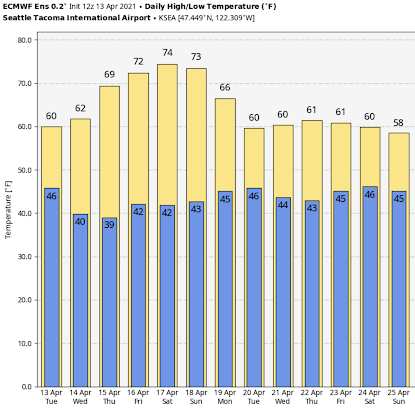
I know your next question. What about the highly skillful European Center forecasts? Here they are (below). Highs of 74 and 73 on Saturday and Sunday, followed by a cool down next week.
What do we owe this turn to torrid conditions?
A very high amplitude upper-level ridge of high pressure over the eastern Pacific. The forecast of upper-level (500 hPa, around 18,000 ft) conditions at 5 PM Wednesday, shows the upper-level ridge extended into BC, with troughs (the L’s) on both sides. This is known as an OMEGA block, because it looks like the Greek letter omega. Very persistent.
And by Friday afternoon the ridge of high pressure amplifies right over us. Such high-pressure areas are associated with sinking air (therefore cloud-free) and warming conditions aloft. At the same time, there is easterly or offshore flow at low levels, which isolates us from the cool Pacific Ocean.
To really warm you up, let me show you the predicted air temperatures just above the surface (2-meters).
The forecast for Wednesday at 5 PM, shows temperatures rising into the mid-60s on both sides of the Cascades, with moderate northerly and northeasterly winds
…click on the above link to read the rest of the article…


