Florida Stores Running Out Of Water, Gas As Gov Warns “Make Sure Your Disaster Kits Are Ready” For Irma
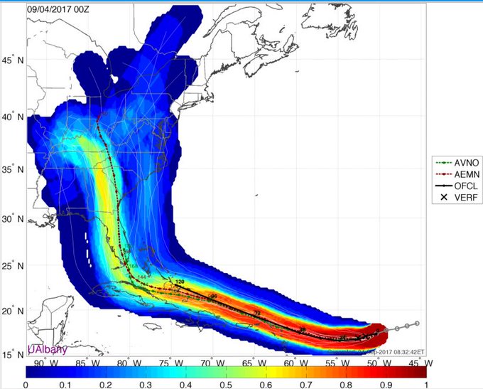
Hurricane Irma is hurtling toward the eastern US faster than meteorological models anticipated. According to the latest readings from NOAA, the storm will probably make landfall in Southeastern Florida next weekend, or perhaps earlier – that is, unless wind patterns intervene and spare residents of Miami, Ft. Lauderdale and West Palm Beach from flooding and winds witnessed in Texas and Louisiana, according to NOAA forecasts.
…Bloomberg chief energy correspondent Javier Blas noted that the Hurricane has “shifted a lot further west,” and that, according to the latest forecasts, there’s still a small chance that Irma strikes the Gulf of Mexico, compounding the devastation that Harvey left behind.
Here’s what we know about Irma (courtesy of the Weather.com & NOAA):
- The center of Irma is located 610 miles east of the Leeward Islands and is moving west-southwestward at about 14 mph.
- Irma is a Category 3 hurricane and satellite imagery shows that it has become better organized in the past day with an eye now clearly evident.
- Low wind shear, increased mid-level moisture and ample oceanic heat content favor that Irma will remain a major hurricane (Category 3 or stronger) for the next several days, though some intensity fluctuations are likely.
- One potential inhibitor of Irma maintaining its intensity would be if the hurricane’s core interacts with land as it cruises westward near the Greater Antilles later this week.
And Weather.com’s latest impact projections:
- Leeward Islands: Late Tuesday-Wednesday
- Puerto Rico/Virgin Islands: Wednesday-Thursday
- Dominican Republic/Haiti: Thursday-Friday
- Turks and Caicos: Thursday-Friday
- Bahamas: Friday-next weekend
- Cuba: Friday-next weekend
- United States: Next weekend into early the following week
…click on the above link to read the rest of the article…


