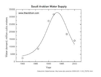
Saudi Arabia Goes the way of the Garamantes. Google Earth Confirms the Collapse of the Water Supply
The old Hubbert model was developed to describe the cycle of extraction of crude oil. It may be oversimplified if you want to use it for detailed predictions. But, as a quick tool for understanding the situation of the production of a non renewable resource, it tells you a lot of what you need to know. That first stab of mine on water production in Saudi Arabia turned out to be correct.
It is impressive how, today, you can use Google Earth to look at the situation “from above.” You can see the collapse of the agricultural fields as depletion progresses. Here are the images of an irrigated area for a region East of Al Jubail, in Saudi Arabia, 26°48’29.60″N and 49° 8’47.58″E.
Let’s start with an image of the desert in 1984. There is absolutely nothing there:
One year later, 1985. Someone has started extracting water and irrigating the land. There are two active fields there.
…click on the above link to read the rest of the article…
