Home » Posts tagged 'flooding' (Page 5)

Tag Archives: flooding

Olduvai
Click on image to purchase

Olduvai III: Catacylsm
Click on image to purchase

Post categories

Post Archives by Category

Climate Change, Midwest Floods & Food Shortages

Climate Change, Midwest Floods & Food Shortages 

The Great Flood of 1927, flooded the lower Mississippi River valley in April 1927.  It was one of the worst natural disasters in American history. More than 23,000 square miles of land was submerged, hundreds of thousands of people were displaced, and around 250 people died. The flooding impacted areas in Arkansas, Illinois, Kentucky, Louisiana, Mississippi, Missouri, Tennessee, Texas, Oklahoma, and Kansas.

Following that Great Flood of 1927, we then see the climate swing dramatically in the opposite direction into the extreme drought that led to the Dust Bowl of the 1930s. The Dust Bowl was a period of severe dust storms that greatly damaged agriculture in the Midwest prairies during the 1930s. The Dust Bowl was a severe drought that came in three primary waves, 1934, 1936, and 1939–1940. The entire event actually complied with our Economic Confidence Model when many regions of the high plains experienced drought conditions for eight years.

Unfortunately, the global warming people are already out in force and blaming this on moms driving the kids to soccer matches. They always pretend these are catastrophic events never before seen. Cars were not really in wide use until post-1940s. They could care less about history or truth. The cycle is very clear. This major flooding which may destroy at least 6 billion bushels of wheat is a prelude to what is coming.

Long before there was the Global Warming crowd, there were the record-setting heat waves and drought of the 1930s that contributed to the Great Depression and wiping out agriculture that was employing 40% of the civil workforce at the start of the century. There were runs of extreme temperatures which broke all records. There was a stretch of 11 days straight in July with temperatures over 100. The two worst years were 1930 and 1936.

 …click on the above link to read the rest of the article…

Government Warns Of Historic, Widespread Flooding “Through May” – Food Prices To Skyrocket As 1000s Of Farms Are Destroyed

Government Warns Of Historic, Widespread Flooding “Through May” – Food Prices To Skyrocket As 1000s Of Farms Are Destroyed

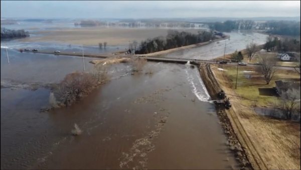
We have never seen catastrophic flooding like this, and the NOAA is now telling us that there will be more major flooding for at least two more months.  On Thursday, the National Oceanic and Atmospheric Administration warned that “historic, widespread flooding” would “continue through May”.  More than 90 percent of the upper Midwest and Great Plains is currently covered by an average of 10.7 inches of snow, and all of that snow is starting to melt.  That means that we are going to transition from one of the worst winters in modern history to a flood season that has already taken an apocalyptic turn for farmers all across America.  At this moment, millions of acres of farmland are already underwater.  Thousands of farmers are not going to be able to plant crops this year, and thousands of other farmers that have been financially ruined by the floods will never return to farming again.  This is already the worst agricultural disaster in modern American history, and it is going to get a whole lot worse.

I posted an article about this crisis yesterday, and I am troubled by the fact that most Americans don’t seem to understand the gravity of what we are facing.

Millions of bushels of wheat, corn and soybeans have been destroyed by flood waters, hundreds of millions of dollars worth of livestock have been lost, and all of us will soon be feeling a lot more pain at the grocery store.

And this would be a complete and utter national nightmare even if the flooding was all over, but the NOAA just told us that we should expect more catastrophic flooding for the next two months

 …click on the above link to read the rest of the article…

Catastrophic Flooding In The Midwest Could Last “For Months”, And That Is Going To Mean A Dramatic Drop In U.S. Food Production

Catastrophic Flooding In The Midwest Could Last “For Months”, And That Is Going To Mean A Dramatic Drop In U.S. Food Production

The worst flooding disaster in the history of the Midwest is just getting started, and as this crisis unfolds we are all going to be feeling the pain.  The “bomb cyclone” that recently brought hurricane-force winds and blizzard conditions to the middle of the nation was the spark that set off this catastrophic flooding, and now all of the snow from one of the snowiest winters in decades is going to be feeding into rivers that have already shattered all-time flood records.  As you will see below, most of the Great Plains and Upper Midwest is currently covered by more than 10 inches of snow, and all of that water has to go somewhere.  As all of that snow melts, we are going to witness an agricultural disaster that is far beyond anything that we have ever seen before in modern American history.

If you think that I am exaggerating even a little bit, please read this article all the way to the end.

As I did research for this article, I was floored by the immense devastation that has already taken place.  But if the crisis was over, at least farmers could start picking up the pieces.

Unfortunately, the crisis is not over.  In fact, Iowa Governor Kim Reynolds is saying that we are “just getting started”.  The following comes from a USA Today article entitled “‘It looked like an ocean’: Severe Midwest flooding could last all spring”

Gov. Kim Reynolds is warning Iowans what millions of Midwesterners have come to understand in recent days – the severe flooding that has swamped much of the regionmay be a long way from over.

 …click on the above link to read the rest of the article…
Weather Patterns Go Crazy: Nebraska Flooding Has Broken 17 Records And Farmers Are Being Absolutely Devastated

Weather Patterns Go Crazy: Nebraska Flooding Has Broken 17 Records And Farmers Are Being Absolutely Devastated

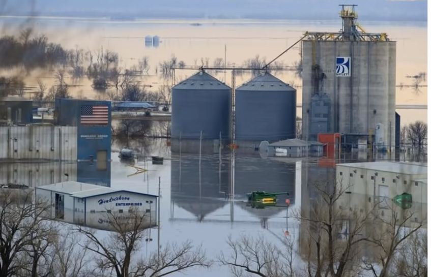
One record breaking disaster after another has been hitting America in recent months.  At this moment, Nebraska is dealing with the worst flooding that it has ever experienced, and the economic damage being done by all of this flooding is going to be absolutely crippling for many farmers.  Of course the floods are the result of the “bomb cyclone” that brought hurricane-like winds and blizzard conditions to the central part of the country last week.  Sadly, this was just the latest chapter in a very cold and very bitter winter that can’t end soon enough as far as many of us are concerned.

Unfortunately, a change in the seasons is not going to be enough to restore our weather patterns to normal.  Prior to this winter, I repeatedly warned that this was going to be an extraordinarily cold and snowy winter, and it turns out that I was exactly correct.

So how did I know this would happen?

Well, it is actually very simple.  I listened to the scientists that were warning us that our sun is exhibiting very unusual behavior, that Earth’s north magnetic pole has been shifting, and that global weather patterns are changing dramatically.

It is not an exaggeration to say that weather patterns here in the United States are literally going crazy.  Los Angeles just had the coldest February that it has seen in 60 years, Seattle just had their snowiest February in 70 years, and some parts of California received more than 500 inches of snow this winter.

And now we are being warned that we could have a very rainy spring, but it is hard to imagine that things could get any worse than they currently are in the central part of the nation.

 …click on the above link to read the rest of the article…

California’s Next Calamity: Storms Compounded By High Tides

California’s Next Calamity: Storms Compounded By High Tides

The wildfires that have taken their toll on California could be just the beginning of the state’s calamities. Now, the high tides of winter are coming and if those tides are worsened by an incoming storm, they could devastate entire cities on the coasts.

On December 10, the National Oceanic and Atmospheric Administration (NOAA) released a report stating there is an 80 percent chance of an El Niño event this winter. Such events are associated with wetter and more intense winter storms. However, NOAA does caution that its data are from September through November and the intensity of the El Niño will not be known for quite some time still.

Tides are determined by the sun and moon’s gravitational pull on the oceans. This warning from NOAA comes as heavy storms bear down on California’s Pacific Northwest.   In central and northern California on Monday,  waves were as high as 30 feet, with 40- to 50-foot breaks. Coastal flooding and erosion were reported. And sn even-more-powerful storm smacked the region yesterday, prompting flood watches, high-wind alerts, and winter storm warnings across nine states.

According to ABC News, holiday travelers along I-5, which runs north to south through Washington, Oregon, and California, can expect to be drenched with heavy rains. Although that storm has mostly passed and is headed to the Rocky Mountains, California is not out of the woods just yet. High surf warnings were issued by the National Weather Service from Point Conception, California, north of the Los Angeles  Basin, to the coast of southwestern Washington, highlighting an especially heightened threat to life and property within the surf zone, reported Weather.com. 

…click on the above link to read the rest of the article…

Evacuations Ordered As “Monstrous Hurricane” Michael Intensifies Into “Most Powerful Storm In A Decade

In a repeat of the scramble for safety that preceded the landfall of Hurricane Irma during the 2017 storm season, residents of the Florida panhandle are boarding up homes and fleeing inland as Hurricane Michael, already a Category 1 storm following a rapid intensification over the past 24 hours, barrels toward the northern Gulf of Mexico, where it’s projected to make landfall on Wednesday, possibly as a Category 3 storm.


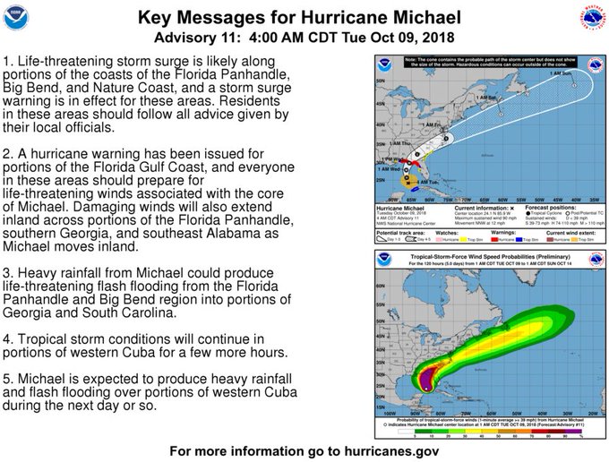
Hurricane Michael is moving north-northwestward over the Gulf of Mexico. Here are the 4 am CDT October 9th Key Messages on Hurricane .

“The center of Michael is expected to move inland over the Florida Panhandle or Florida Big Bend area on Wednesday, and then move northeastward across the southeastern U.S. Wednesday night and Thursday,” the U.S. National Hurricane Center said in an advisory at 5 a.m. New York time.

Michael

The hurricane could generate a 12-foot surge, and 4-8 inches of rain in the region, with isolated areas getting as much as 12 inches. Michael is arriving less than a month after Florence hit North Carolina on Sept. 14, causing devastating floods, killing at least 39 and causing about $45 billion in estimated damages. Duke Energy Corp. warned customers in the region to prepare for potential outages.

After initially forming over the coast of Honduras, Michael battered western Cuba and Mexico’s Yucatan Peninsula over the weekend, causing flash flooding that left 13 dead, per CNN. With a hurricane warning in place from the Alabama-Florida border to the Suwannee River in Florida, and a hurricane watch in effect for the coast of Alabama, Florida’s governor Rick Scott called Michael “a monstrous hurricane“, and declared a state of emergency for 35 Florida counties from the panhandle to Tampa Bay.

Michael

…click on the above link to read the rest of the article…

South Carolina Still Grappling with Historic Flooding from Florence, a Storm Worsened by Climate Change

South Carolina Still Grappling with Historic Flooding from Florence, a Storm Worsened by Climate Change

April O'Leary kayaks to her flooded home in Conway, South Carolina

South Carolina was spared the worst of Hurricane Florence’s fury when the storm made landfall in North Carolina on September 14, but did not escape its catastrophic impacts. Nearly two weeks later, the state was still contending with historic flooding.

Flooded house on South Carolina coast
Flooded house in Socastee, South Carolina.

Florence lingered over the Carolinas, dumping more than 30 inches of rain in some areas. Five rivers and the IntraCoastal Waterway crested several feet above major flood stage, resulting in flooding that will last for weeks to come in parts of South Carolina. Cities and towns on its northern coast are experiencing the worst of it, where standing water remains in buildings along the Intracoastal Waterway and near riverbanks deep into the Carolinas.

Flooded mobile home in Bucksport, South Carolina, after Hurricane Florence
Flooded mobile home in Bucksport, South Carolina.

Floodwaters overwhelm Pine Grove Baptist Church in Brittons Neck, South Carolina
Pine Grove Baptist Church in Brittons Neck, South Carolina.

Jane and Chris Ochsenbein, owners of Gator Bait Adventure Tours in Myrtle Beach, South Carolina, took me on a kayak tour of flooded areas 10 days after the storm hit the coast.

On September 26, we met up with April O’Leary, a program officer for Winyah Rivers Foundation and the Waccamaw Riverkeeper program, in Conway, a city about 15 miles from South Carolina’s coast.

Chris Ochsenbein pulls a kayak into floodwaters in Conway, South Carolina
Chris Ochsenbein pulling a kayak into floodwater in Conway, South Carolina’s Sherwood neighborhood.

April O'Leary stands in chest waders in floodwaters outside her home in Conway, South Carolina
April O’Leary, in front of her flooded home in Conway, South Carolina, on September 26.

We paddled our way to her home in Conway’s Sherwood neighborhood the day that the Waccamaw River crested, reaching 21.16 feet, 7 feet over major flood stage. O’Leary later told me that level set a new record by more than three feet. The previous record, 17.89 feet, was set following Hurricane Matthew just two years earlier.

…click on the above link to read the rest of the article…
Economic Damage Wrought By Hurricane Florence Nearly 10 Times Worse Than Expected

Rivers in the Carolinas are still rising and North Carolina Gov. Roy Cooper has warned that it still isn’t safe for displaced residents to return to their property. But that hasn’t stopped Moody’s from releasing the first estimate of the economic damage wrought by Hurricane Florence.

According to the Wall Street Journal, the ratings agency’s estimates put the total economic toll at somewhere between $38 billion and $50 billion – more than double an initial estimate of between $8 billion and $20 billion from Goldman Sachs and S&P.And nearly ten times CoreLogic’s initial estimate of between $3 billion and $5 billion.

If damages reach the upper end of that range, it would leave Florence in seventh place among the biggest storms, just after 1992’s Hurricane Andrew, according to Moody’s estimates.

Florence

Notably, the expected toll is lower than each of last year’s three major hurricanes:

Based on Moody’s estimates, last year’s three hurricanes each caused more damage than Florence: Harvey’s tally reached $133.5 billion; Maria’s $120 billion; and Irma’s $84.2 billion.

Still, the storm has continued to wreak havoc in the region as the death toll has risen to 41. Rivers in the Carolinas have continued to rise, and rescues are still being carried out by first responders. Meanwhile, water levels for the Cape Fear River are expected to peak on Saturday:

Florence, which made landfall Sept. 14 and has claimed 41 lives in the Carolinas and Virginia, is continuing to wreak havoc. Rivers in the Carolinas are continuing to rise, and more than 600 roads were still closed Friday in North Carolina. North Carolina Gov. Roy Cooper warned it still isn’t safe for many people to return home including the 3,700 who remain in shelters.

…click on the above link to read the rest of the article…

Florence Death Toll Climbs To 17 As 3-Month-Old Dies; Wilmington “Virtually Cut Off”

The storm that is now known as Tropical Depression Florence has seen its winds slacken since it first reached the Carolina coast on Friday (though it has battered parts of the state with wind and rains since Thursday), but the unceasing rains have continued, breaking floodwater records in North Carolina and pushing the death toll from the disaster past 17 individuals, as exhausted first responders have been overwhelmed by the number of calls. Meanwhile, more than 1 million people remain without power in the region, according to the Department of Energy (though the DoE said it had some success in restoring access to customers).

However, some of the hardest-hit areas may be without power for weeks.

“We still continue to see heavy rainfalls in both states,” Jeff Byard, associate administrator for response and recovery at the Federal Emergency Management Agency, said of North and South Carolina. “We want citizens to follow state and local warnings. There is a tremendous amount of flooding.”

With the damage and mayhem wrought by the storm exceeding expectations, the federal government was scrambling on Monday to mobilize thousands of National Guard soldiers and scores of aircraft. The Army Corps of Engineers continued to monitor federal dams and help with rescues as pumps and portable barriers were deployed while specialized search-and-rescue teams arrived from as far away as New York and Nevada. 

According to the Washington Post, the city of Wilmington – which has been the hardest hit city – has been “virtually cut off” from the rest of the state by the rising floodwaters. At least 450 people have been rescued.

…click on the above link to read the rest of the article…

Next Phase Of Florence Disaster Arrives: “Catastrophic” River Floods, Massive Mudslides

As meteorologists expected, the storm formerly known as Hurricane Florence (it was downgraded to a tropical depression on Sunday after previously being cut to a tropical storm) is stubbornly lingering over the Carolinas and dumping an unceasing assault of warm ocean water on the state.

Radar showed that parts of the storm were impacting six states, but North and South Carolina remained in the bulls eye. The worst hit parts of North and South Carolina have already been inundated with more than two feet of rain, and forecasters are saying there could be an additional 1.5 feet before the end of day Sunday, according to the Associated Press. For this reason, disaster analysts have said the storm is expected to be the costliest in US history, with damages exceeding $170 billion.


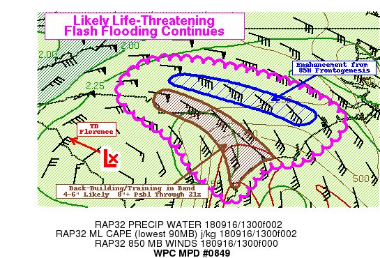
Here is a new mesoscale precipitation discussion from @NWSWPC on ongoing life-threatening flash flooding from in southern NC and northern SC https://www.wpc.ncep.noaa.gov/metwatch/metwatch_mpd_multi.php?md=0849&yr=2018 


While wind speeds have slackened to 35 mph from an initial windspeed of more than 90 mph when Florence first came ashore, the storm has continued its crawl west at 8 mph. At 5 am, the storm was centered about 20 miles southwest of Columbia, South Carolina.

Flooding

Meteorologists forecast “catastrophic” flooding in both North and South Carolina, as some areas will be coated with more than 40 inches of rain, according to USA Today. Meanwhile, the death toll has risen to 15 people, and is expected to rise.

“These rainfall amounts will produce catastrophic flash flooding, prolonged significant river flooding and an elevated risk for landslides in western North Carolina and far southwest Virginia,” the hurricane center warned.

…click on the above link to read the rest of the article…
“Worst Storm In US History” Florence Set To Break All-Time Records; Forecasters Fear Harvey Flood Redux

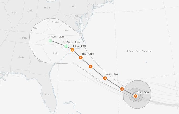
The latest computer forecasts from Tuesday afternoon have predicted that Hurricane Florence, still a Category 4 yet growing larger and more powerful, may shift and hit somewhere near the border between North and South Carolina as coastal residents flee what may be the most powerful hurricane to hit the state in 64 years, according to Bloomberg.

“Florence is expected to stall and wander near or over the coast for as many as four days, dumping prodigious amounts of rain,” said meteorologist Jeff Masters of Weather Underground, who added “If a significant portion of the storm’s circulation remains over water, as occurred last year with Hurricane Harvey’s stall over Southeast Texas — or even if Florence were to move into the higher terrain of western North Carolina and then stall — the rain may break all-time state records for rainfall from a hurricane or tropical storm.


Southeast braces for Hurricane : https://abcn.ws/2N39hJ4


…click on the above link to read the rest of the article…

Nuclear Power Plants At Risk Of Direct Hit By Hurricane Florence

North and South Carolina nuclear power plants are in line for a possible direct hit from Hurricane Florence.

According to the Nuclear Regulatory Commission (NRC), there are twelve operating nuclear power plants in the Carolinas that make electricity by the continuous splitting of uranium atoms (i.e., a nuclear reaction). These plants generally reside near a body of water—a river, lake, estuary or ocean—because they require a constant source of water for cooling purposes. Without cooling water, a nuclear reactor will overheat, leading to core damage, containment failure, and release of harmful radiation into the environment.

“Florence will approach the Carolina coast Thursday night into Friday with winds in excess of 100mph along with flooding rains. This system will approach the Brunswick Nuclear Plant as well as the Duke-Sutton Steam Plant,” said Ed Vallee, a meteorologist at Vallee Wx Consulting.

“Dangerous wind gusts and flooding will be the largest threats to these operations with inland plants being susceptible to inland flooding,” said Vallee.

He tweeted a few weather models Tuesday morning that forecasts rainfall amounts 15-40″ range in some regions along the coast.

One of those models is the ECMWF Total Precipitation, which shows the most torrential rain could be situated around the two nuclear power plants in Wilmington, North Carolina.

Also, there is a significant risk of “a life-threatening storm surge” of up to 20 feet or higher along the coast where the nuclear power plants sit.

“The latest forecast is projecting that Hurricane Florence willstrengthen “to near category 5 strength” before it makes landfall in the Carolinas, and it is being called “a serious threat to lives and property”. It is extremely rare for a hurricane of this intensity to come this far north, and one expert is claiming that Florence “has the potential to be the most destructive hurricane we’ve had in modern history for this region.”

…click on the above link to read the rest of the article…

Millions Brace For Cat 4 Hurricane Florence, Threatened By “Historical Inland Flooding”

With mandatory evacuations issued for coastal regions of North and South Carolina and Virginia, millions of Americans are preparing for what could be the most catastrophic hurricane to hit the US East Coast in many decades. The latest report from the National Hurricane Center (NHC) indicates that Hurricane Florence is packing winds up to 140 mph as a Category 4 storm, which could strengthen and become a Category 5 storm Tuesday.

Computer models forecast the storm to make landfall in North or South Carolina on Thursday, hitting a stretch of coastline that is already vulnerable to sea level fluctuations with 30- to 40-foot waves.

By 5 a.m. Tuesday, the NHC released a report specifying Florence was about 975 miles east-southeast of Cape Fear, North Carolina, and moving west-northwest at 15 mph. Its center will be wedged between Nassau and Bermuda on Wednesday and approach the coast of South and North Carolina on Thursday, as a possible Category 4/5 storm.

“The storm looks very bad!” President Donald Trump tweeted Monday afternoon.

South Carolina Gov. Henry McMaster ordered an estimated 1 million people to evacuate from coastal areas of the state as Florence strengthened to a Category 4 storm Monday. North Carolina Gov. Roy Cooper, who ordered an estimated 250,000 residents and visitors to begin evacuating the Outer Banks barrier islands. And Virginia’s governor ordered a mandatory evacuation for some residents of low-lying coastal areas.

…click on the above link to read the rest of the article…

Extreme Flash Floods Hit Hawaii As Dangerous Hurricane Lane Could Dump “30-40 Inches Of Rain”

This threat of extreme flooding could occur across most of the island chain was summed up succinctly by The Weather Channel hurricane expert Dr. Rick Knabb in a tweet late Thursday night.

Meteorologists said Lane’s eye passed over a weather buoy about 250 miles southwest of the Big Island on Thursday morning and recorded winds that sustained +100 miles per hour.

NOAA: Dangerous Hurricane Lane Moving North Toward The Main Hawaiian Islands

“The slow movement of Lane also greatly increases the threat for prolonged heavy rainfall and extreme rainfall totals,” the Central Pacific Hurricane Center (CPHC) said. “This is expected to lead to major, life-threatening flash flooding and landslides over all Hawaiian Islands.”

“The center of Hurricane Lane was located near latitude 18.2 North, longitude 158.0 West. Lane is moving toward the north near 6 mph (9 km/h), and this general motion is expected to continue through Friday. A turn toward the west is anticipated Saturday, with an increase in forward speed. On the latest forecast track, the center of Lane will move over, or dangerously close to portions of the main Hawaiian islands late Friday and Friday night.

…click on the above link to read the rest of the article…

Dangerous climate tipping point is ‘about a century ahead of schedule’ warns scientist

Dangerous climate tipping point is ‘about a century ahead of schedule’ warns scientist

A slowing Gulf Stream system means catastrophic East Coast flooding will get much worse.

Taxis sit in a flooded lot after Hurricane Sandy October 30, 2012 in Hoboken, New Jersey. CREDIT: Michael Bocchieri/Getty Images
TAXIS SIT IN A FLOODED LOT AFTER HURRICANE SANDY OCTOBER 30, 2012 IN HOBOKEN, NEW JERSEY. CREDIT: MICHAEL BOCCHIERI/GETTY IMAGES
New research provides strong evidence that one of the long-predicted worst-case impacts of climate change — a severe slow-down of the Gulf Stream system — has already started.
The system, also known as the Atlantic Meridional Overturning Circulation (AMOC), brings warmer water northward while pumping cooler water southward.

“I think we’re close to a tipping point,” climatologist Michael Mann told ThinkProgress in an email. The AMOC slow down “is without precedent” in more than a millennium he said, adding, “It’s happening about a century ahead of schedule relative to what the models predict.”

The impacts of such a slowdown include much faster sea level rise — and much warmer sea surface temperatures — for much of the U.S. East Coast. Both of those effects are already being observed and together they make devastating storm surges of the kind we saw with Superstorm Sandy far more likely.

The findings come in two new studies published this week. One study published in the journal Nature, titled “Observed fingerprint of a weakening Atlantic Ocean overturning circulation,” was led by the Potsdam Institute for Climate Impact Research. It finds that the AMOC has weakened “around 15 per cent” since the mid-twentieth century, bringing it to “a new record low.” 

Another new study in the same issue of Nature “supports this finding and places it in a longer climate history context,” as Potsdam’s Stefan Rahmstorf notes at RealClimate

…click on the above link to read the rest of the article…

Olduvai IV: Courage
Click on image to read excerpts

Olduvai II: Exodus
Click on image to purchase

Click on image to purchase @ FriesenPress