U.S. Disaster Zones: Are You Living In A Place Where Disasters Are Common?

In just the past 16 years, parts of Louisiana have been struck by six hurricanes. Areas near San Diego were devastated by three particularly vicious wildfire seasons. And a town in eastern Kentucky has been pummeled by at least nine storms severe enough to warrant federal assistance. These are obvious red flag areas, but what about the rest of the country?
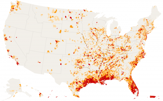
The New York Times has put together a map showing which areas in the United States were subjected to the most disasters which caused monetary losses by ZIP code between 2002 – 2017.
$150,000 $500,000 $1 million $5 million

All the maps in show losses verified by the Small Business Administration for disasters in which a presidential disaster declaration was issued. The values of the losses are expressed in 2017 dollars.
The statistics for living in the “red zones” in the above map are not comforting either. About 90 percent of the total losses across the United States occurred in ZIP codes that contain less than 20 percent of the national population, according to an analysis of data from the Small Business Administration.
In the first three months of 2018, billion-dollar storms hit the United States three times. By contrast, in the first three months of an average year, just one disaster that causes more than a billion dollars in damages occurs, according to National Oceanic and Atmospheric Administration records dating back to 1980.
…click on the above link to read the rest of the article…