Home » Posts tagged 'winter weather' (Page 3)

Tag Archives: winter weather

Olduvai
Click on image to purchase

Olduvai III: Catacylsm
Click on image to purchase

Post categories

Post Archives by Category

A Simple Plan to Prepare for the Most Likely Winter-Related Emergencies

A Simple Plan to Prepare for the Most Likely Winter-Related Emergencies

Many overestimate their abilities to withstand winter-related emergencies and fail to adequately prepare, thus leaving themselves exposed. The following are the five most-likely winter emergencies and some tips and resources to help you prepare.

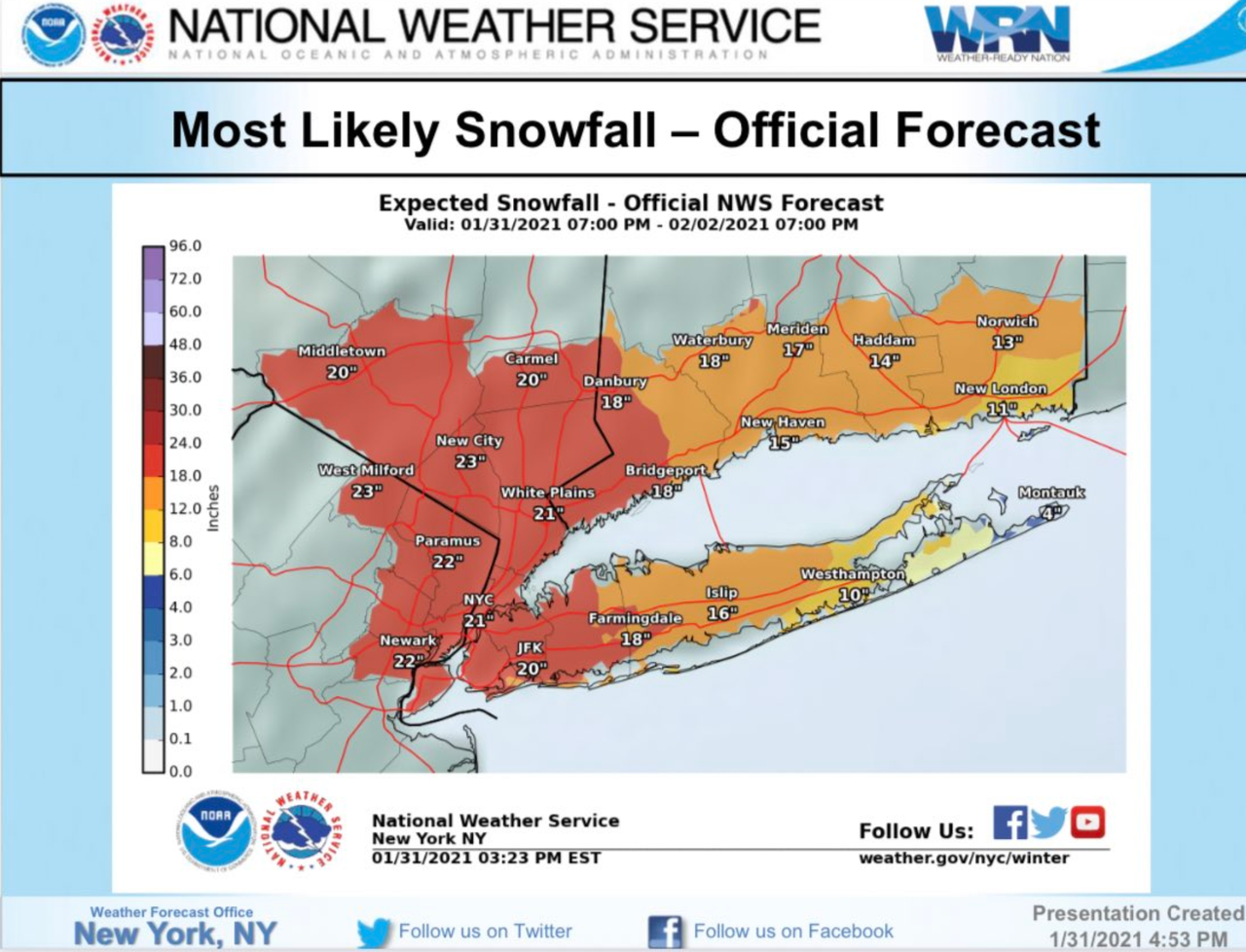
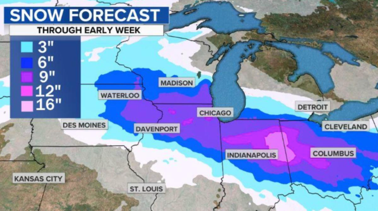
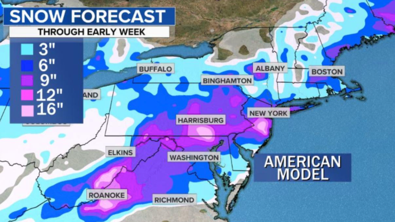
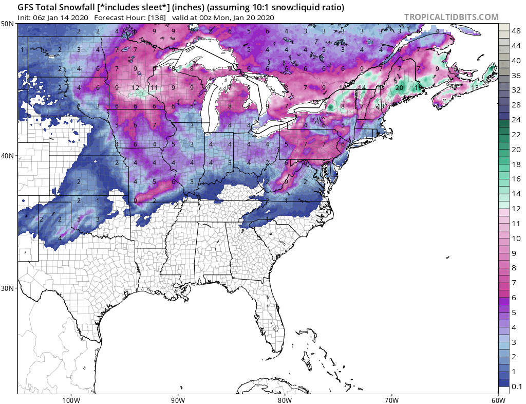
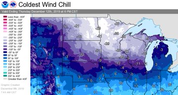
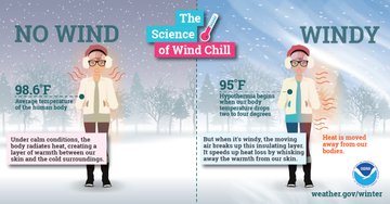
Whenever temperatures drop decidedly below normal and as wind speed increases, heat can leave your body more rapidly. These weather-related conditions may lead to serious health problems. The reason being is that our bodies are not built to withstand long bouts of extreme weather. Lower body temperature can cause your heart, nervous system, and other organs to enter a state of shock, putting a person at risk of a heart attack, respiratory system failure, and possibly death.

Many overestimate their abilities to withstand winter-related emergencies and fail to adequately prepare, thus leaving themselves exposed. The following are the five most-likely winter emergencies and some tips and resources to help you prepare.

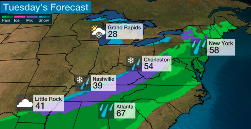
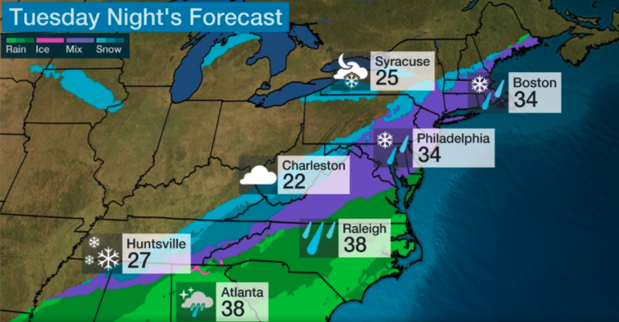
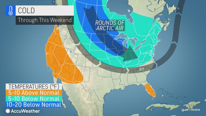
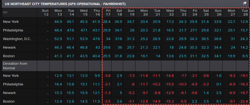
Cold-related health problems, including frostbite and hypothermia.

Here is a great article on how to avoid cold exposure and some tips on what to avoid. As well, knowing the type of gear to have on hand can make all the difference in the world. Here are 10 first-aid supplies to have on hand to assist with hypothermia exposure and some tips on winterizing your bug-out bag to prevent this medical issue. As well, with any of the following winter emergencies, never underestimate the power of having the right type of winter clothes to keep your core warm. Layering clothing works by trapping warm air created by your own body heat in between the many layers of clothing…

…click on the above link to read the rest of the article…

La Nina To Blast Europe With Cold Snap Amid Energy Crisis  

La Nina To Blast Europe With Cold Snap Amid Energy Crisis  

Energy prices in Europe are expected to increase as new weather models forecast a plunge in temperatures to begin by the late weekend.

A weather phenomenon known as La Nina will bring below-normal temperatures for continental Europe and the Nordic region by Sunday.

The region is susceptible to cold snaps, with natural gas stockpiles well below average.

On Wednesday, gas prices at the Dutch TTF hub, the benchmark for European gas, are making another attempt at the €100 per MWh mark.

Extra gas supplies by Russia have been mute so far. The Nord Stream 2 pipeline remains in limbo after German energy regulators last week suspended the certification process.

The next round of cold air is going to test energy supplies across Europe. Gas prices are likely to move higher, pushing up power prices. Already, power prices in Finland have jumped five times higher than a year ago.

North West Europe’s average temperatures for the next week are expected to slide well below the 30-year mean through the mid-point of the month.

The same with Nordic areas.

North West Europe’s heating degree days, a measure of heating demand, will be significantly over the 30-year average. The same is with Nordic areas.

On top of the cold, weather observer Electroverse forecasts snow will blanket the continent over the next two weeks.

The development of the La Nina weather pattern has meant unseasonably cold weather for Europe, boosting energy prices but declining prices in the US as weather trends stay warmer. The chart below shows US energy prices negatively diverging the UK and EU gas prices.

Soaring energy inflation and rising food prices are the makings of a ‘winter of discontent’ across Europe. EU politicians beware.

An energy crisis is gripping the world, with potentially grave consequences

How China and Europe are catching the brunt of it

The cooling towers at the coal-fired NTPC Ltd. Dadri Power Plant in Uttar Pradesh, India. The country, which relies on coal for about 70 percent of electricity generation, has already seen signs of power shortages. (Anindito Mukherjee/Bloomberg News)

Energy is so hard to come by right now that some provinces in China are rationing electricity, Europeans are paying sky-high prices for liquefied natural gas, power plants in India are on the verge of running out of coal, and the average price of a gallon of regular gasoline in the United States stood at $3.25 on Friday — up from $1.72 in April.

As the global economy recovers and global leaders prepare to gather for a landmark conference on climate change, the sudden energy crunch hitting the world is threatening already stressed supply chains, stirring geopolitical tensions and raising questions about whether the world is ready for the green energy revolution when it’s having trouble powering itself right now.

The economic recovery from the pandemic recession lies behind the crisis, coming after a year of retrenchment in coal, oil and gas extraction. Other factors include an unusually cold winter in Europe that drained reserves, a series of hurricanes that forced shutdowns of Gulf oil refineries, a turn for the worse in relations between China and Australia that led Beijing to stop importing coal from Down Under, and a protracted calm spell over the North Sea that has sharply curtailed the output of electricity-generating wind turbines.

“It radiates from one energy market to another,” said Daniel Yergin, author of “The New Map: Energy, Climate, and the Clash of Nations.”

…click on the above link to read the rest of the article…

The First Texas-Freeze Casualty: Just Energy Implodes, Issues Going Concern Warning

The First Texas-Freeze Casualty: Just Energy Implodes, Issues Going Concern Warning

Just Energy’s shares crashed more than 21% in the premarket after the company released a statement about steep losses incurred during the winter storms that swept across Texas last week warning of doubts about remaining a ‘going concern’ (translation: it may not survive).

“The financial impact could change as additional information becomes available,” it said in the statement.

“Accordingly, the financial impact of the Weather Event on the Company once known, could be materially adverse to the Company’s liquidity and its ability to continue as a going concern.”

Just Energy hit a record low ($4.05) in premarket trading since it went public in 2002… and peaked above $600 in 2007.

The retail energy provider specializing in electricity and natural gas commodities, renewable energy options, and carbon offsets revealed that it lost $250 million due to Texas’s latest “weather event”.

“The sustained high prices from February 13, 2021 through February 19, 2021, during which real-time market prices were artificially set at USD $9,000/MWh for much of the week, it is likely that the Weather Event has resulted in a substantial negative financial impact to the Company.”

Based on current information available to the company as of the time of this press release, the company estimates that the financial impact of the Weather Event on the company could be a loss of approximately USD $250 million (approximately CAD $315 million), but the financial impact could change as additional information becomes available to the company,” Just Energy stated. 

The company warned the material impact could cause “liquidity” issues and raises doubts it can continue operating. It’s currently talking with top stakeholders regarding the impact of the weather event last week.

…click on the above link to read the rest of the article…

Is Texas Facing A Humanitarian Crisis?

Is Texas Facing A Humanitarian Crisis?

Up to 15 million Texans remain without heat and electricity as temperatures across the state are well below freezing. Another round of winter weather is battering parts of the state Wednesday morning, as many Texans have been without electricity since Sunday are desperately scrambling to find shelters. Weather-related deaths have already been reported as one of the nation’s wealthiest states can barely supply electricity to its residents. And some of those residents have written to us to share their painful realities…

…my house is now resembling a refugee camp. yeah these are all my friends but crazy cause they all have young kids

hence i’m escaping the chaos…

what’s insane is that big swathes of population in surrounding areas are without power and *water supply*

… bottled water flying off shelves & stores bout to run out.

… so much for Green New Deal shit… all our turbines and solar don’t work now in freeze, LOL

i live in an area behind a major hospital so i’m thinking that’s why my grid has been up and running this whole time. 

The unprecedented polar vortex split, dumping Arctic air down to the Gulf of Mexico, resulted in frozen wellheads that impeded the flow of natgas to power stations, triggering electric shortages as demand overwhelmed the grid. Considering ERCOT, which manages 90% of the state’s electric load, has a high percentage of electrical generation produced via natgas, power has yet to be restored to millions of folks.

The cascading effect of blackouts and controlled power outages has resulted in some critical infrastructure such as cellular networks and water treatment plants going offline.

…click on the above link to read the rest of the article…


‘Grid Chaos’ Sparks Massive Rolling Blackouts Across Texas 

‘Grid Chaos’ Sparks Massive Rolling Blackouts Across Texas 

Rolling power outages are in effect across the state of Texas as the polar vortex split has poured some of the coldest air ever into the central US. There are nearly 2 million Texan customers without power as of Monday morning.

Texas power grid operator ERCOT warned Sunday of an “energy emergency” and threatened “rotating outages.” By Monday morning (0125 local time), ERCOT began “rotating outages” to “reduce demand on the electric system.” It continued: “Traffic lights and other infrastructure may be temporary without power.”

As of 0700 ET, PowerOutage.US shows 1.834 million customers are without power across the state amid frigid temperatures.

ERCOT officials said outages are expected to last between 15 and 45 minutes. They say blackouts are “necessary to maintain the system’s reliability.” Power demand is expected to remain at record levels through Tuesday as record-low temperatures will stay in the region through the week.

“Every grid operator and every electric company is fighting to restore power right now,” said Bill Magness President and Chief Executive Officer of ERCOT. 

Temperatures across Texas and the central US are expected to be well below normal through the end of the week.

ERCOT’s decision to implement rolling power outages comes after we first warned of an imminent grid crisis on Thursday, when we reported that natgas prices across the plains states had soared to never before seen levels as a result of a brutal polar vortex blast.

… which cut off natgas supply amid wellhead freeze-offs, cutting production receipts just when customers’ demand for heating most needed them. By Friday, frigid temperatures caused equipment failures, temporarily shutdowns in at least four natgas plants.

Over the last 24 hours, hundreds of daily records for cold temperatures were broken as Arctic air pushed all the way down to the Gulf of Mexico.

…click on the above link to read the rest of the article…


“Overwhelming Signal” – Major Winter Storm Threats For Million Of Americans Within Next Five Days

“Overwhelming Signal” – Major Winter Storm Threats For Million Of Americans Within Next Five Days

Earlier this week, we told readers in a note titled “Prepare For “Onslaught Of Winter Storms” In Coming Days” that “multiple rounds of snow, ice in the Midwest and East as bitterly cold temperatures grip parts of the nation.” A new weather model released on Thursday suggests this Saturday through next week potentially dangerous winter storms could materialize.

On Thursday, meteorologists at BAMWX updated their “Impactful Weather Outlook” between Feb. 13 and Feb. 21, indicating: major winter storms are possible” from Denver to Dallas to Chicago to Cleveland to Mid-Atlantic and Northeast states.

“An overwhelming signal seems to be developing for a major winter storm from the Deep South to the Ohio Valley into the NE early next week. Heres our 3-7 day hazards map and a blend of models 75th percentile data. Worth note deterministic data showing major snow numbers. #Snow,” BAMWX’s official Twitter account tweeted. 

Along with multiple storms forecasted across Midwest to the Northeast, a polar vortex split has dumped the winter’s most brutally cold weather into the country’s mid-section and the Northeast. This week temperatures were as low as 43 degrees below zero in northern Minnesota.

Diving temperatures helped catapult propane demand to a 17-year high last week.

Source: Bloomberg 

Arctic temperatures forced tens of millions of Americans to turn up their thermostats. Cooler temps could be sticking around through at least the mid-part of the month.

Increased demand for propane sent spot prices in Mont Belvieu, Texas, soaring, to around 85.50 cents per gallon, according to Refinitiv data, hitting two-year highs last month.

Besides propane, spot natgas prices have exploded in Texas, Oklahoma, Kansas, as a sharp rise in heating demand has been seen in recent weeks because of fridge temperatures.

…click on the above link to read the rest of the article…


Major Nor’easter Could Bury NYC In Two Feet Of Snow 

Major Nor’easter Could Bury NYC In Two Feet Of Snow 

Tens of millions of people across the Northeast are waking up Monday to 2021’s first major snowstorm with up to two feet and whiteout conditions in certain areas.

National Weather Service’s Event Summary Of Major Nor’easter

Winter Storm Watches & Warnings 

NBC News meteorologist Bill Karins said the Tri-State area could see the largest snowstorm in half a decade. Karins forecasts New York City could receive up to 20 inches of snow or more.

National Weather Service’s Official Snowfall Predictions  

On Sunday, New York Mayor Bill de Blasio said the city’s school system would be closed. He said appointments for coronavirus vaccinations would be put on hold and rescheduled.

“The last thing we want to do is urge our seniors to come out in the middle of a storm like this,” de Blasio said.

He tweeted Sunday night:

“Beginning 6 AM tomorrow, February 1, nonessential travel will be restricted in New York City. This winter storm will be dangerous with heavy snowfall and strong winds. If you can stay home, stay home. Keep the roads clear for emergency vehicles.”

The 48-hour weather event could result in 1 to 2 inches per hour of snow and 40-50 mph wind gusts on Monday, indicating whiteout conditions are expected in certain areas. ABC7 meteorologist Jeff Smith said this system is a “rare snowstorm the likes of which we see every five to 10 years.”

…click on the above link to read the rest of the article…

Powerful Snowstorm Could Impact 100 Million People From Midwest To Northeast

Powerful Snowstorm Could Impact 100 Million People From Midwest To Northeast

A powerful winter storm starting on Saturday through early next week could impact more than 100 million people across the Midwest to the Northeast.

CBS News reports from Chicago to Cleveland to Baltimore to New York, tens of millions of people could be impacted by severe winter weather starting on Saturday and lasting through Tuesday.

The system has already dumped upwards of 15 inches of rain in some parts of California and in higher elevations, up to 100 inches of snow this week. We noted earlier that an atmospheric river emanating from over the Pacific Ocean would create severe weather for parts of California that would eventually lead to a snowstorm for Midwest and Northeast states.

Ahead of the storm’s arrival, much of the Mid-Atlantic and Northeast are experiencing frigid temperatures.

Heavy snow is likely to fall across the Midwest and Ohio Valley Saturday night and Sunday. Chicago, Indianapolis, and Colombus could see anywhere from 6-12 inches by Sunday night.

“The snow may be heavy at times in places like Washington, D.C.,” CBS said. 

While CBS is only offering weather models of what may happen – their meteorologists ask a few questions about the potential track of the system:

“Now comes the tricky part. Does the storm slide eastward out to sea, keeping cold air locked into the Washington area and the heavy snow bullseye between D.C. and Atlantic City? Or does the storm move northeastward, burying New York City, Providence and perhaps Boston in over a foot of snow? ” 

Forecasts for Monday shows New York City could get walloped with snow.

The mid-Atlantic and Northeast states’ total snowfall forecasts through early next show significant accumulation could be ahead.

While everyone might take a snowday or two early next week, that will give even more people the opportunity to trade GameStop and other most shorted stocks. Here’s a list of the next most shorted stocks.

Spanish Energy Markets Roiled Amid Chilling Temps

Spanish Energy Markets Roiled Amid Chilling Temps

A cold snap across Spain is expected to last through mid-January has resulted in natural gas prices more than doubling in the last week, according to Bloomberg.

LNG prices trading at Spain’s Punto Virtual de Balance (PVB) gas trading hub hit a record 51.55 euros ($63.13) a megawatt-hour this week, or $18.54 per million British thermal units as the nation grapples with dangerously cold weather and snowfall in Madrid.

Spain has one of the largest LNG terminals in Europe. “Surging prices, coupled with a lack of available LNG vessels for longer journeys between Europe and Asia, will probably limit cargo exports from the nation’s ports and further tighten the supply of the fuel,” Bloomberg noted.

Frigid weather in China has resulted in surging LNG prices as well. This week Beijing meteorological station recorded one of the coldest temperatures in decades this past week, sending power demand through the roof. LNG imports in China last month were at record highs as demand to heat homes has surged.

A possible theory behind the wicked cold weather could be the sudden stratospheric warming splitting the polar vortex into two, allowing Arctic temperatures to pour into Europe and Asia.

“A strong sudden stratospheric warming event (SSWE) over the Pole has temperatures spiking in the Arctic, plummeting in portions Europe and Asia.

The remnants of the Polar Vortex (PV) has also aided in unusual heavy snow in the forecast across portions of Spain in…forecast models spitting out over 12″ + of snow in the short term. While these areas of the world feel more “wintry”, it has allowed especially the northern half of the US to run much above normal in temperatures, losing our tap to cold air. Signs will need to be watched getting later into January, however, for the increased potential for cooler or colder outbreaks of air across the eastern/southern US if we can move the remnants of the PV more towards the US,” said Kirk Hinz, meteorologist with BAM Weather

Extreme ocean-effect snow buries parts of Japan beneath seven feet, with more coming

The nation was sandwiched in between record-breaking weather systems.

The American GFS model simulates heavy snow targeting Japan during the next week. (WeatherBell)

Barely two weeks after a prolific ocean-effect snowstorm dropped seven feet of snow and stranded thousands of motorists, the new year in Japan kicked off with another severe snowstorm. Up to another 85 inches fell through Saturday amid strong winds and record cold temperatures.

Photos emerged on social media of a landscape plastered in white as heavy snow covered the mountains of Japan. One shot captured a roughly five-foot block of snow balanced precariously on a phone booth, while another showed what appeared as a white blanket presumably cloaking trees, structures and vehicles.

The mind-boggling snowfall is linked to a pair of record-breaking weather systems that induced a prolonged period of westerly to northwesterly winds, the ideal wind fetch needed to yield the factory-like production and dumping of heavy snow.

Mountainous areas of Japan are bracing for yet another dump of heavy snow over the next five days.

The second extreme snowfall in two weeks’ time

Japanese news agency NHK reported that Okura Village in Yamagata Prefecture, a mountain community a little more than 200 miles north of Tokyo, had received 85 inches of snow by late Friday. The seven feet of snow matched what came down the week of Dec. 18 just to the south in the community of Fujiwara.

That snowstorm stranded more than a thousand motorists on the Kan-Etsu Expressway for more than 24 hours, with drivers forced to melt snow for drinking water during the overnight debacle.

…click on the above link to read the rest of the article…


Major Winter Storm Threatens Millions In Northeast This Weekend

Major Winter Storm Threatens Millions In Northeast This Weekend

A powerful winter storm is expected to dump snow and ice across the Midwest and Northeast this weekend. 

Early indications suggest wintry precipitation is possibly Saturday as the winter storm transitions from Midwest states to the Mid-Atlantic and Northeast, while heavy snow could fall in some areas. 

We noted on Monday how the Global Forecast System (GFS) data shows Old Man Winter will return to the Northeast on Friday with average temperatures from Washington, D.C., to Boston around 25 to 34 degrees. This could make conditions ripe for a snowstorm over the weekend. 

The National Weather Service (NWS) is projecting that snow and ice could be seen on early Saturday for Mid-Atlantic states, with mixed precipitation in the afternoon. The further north, the higher the probability of significant snowfall. 

“Although confidence continues to increase on the potential for a winter storm for parts of our area (above average confidence for this time range, in fact), it is still too early to get into specifics on timing and amounts of different precipitation types given … this is still 4 to 5 days away,” NWS said Tuesday. 

Henry Margusity, a meteorologist for Weather Madness, provides several weather charts that indicate the storm could quickly impact tens of millions of folks in the Mid-Atlantic and Northeast this weekend. 

Margusity provides another chart showing the winter precipitation could start early Saturday morning in the Baltimore–Washington Metropolitan Area and move up the Interstate-95 corridor in the Northeast through Saturday afternoon into the evening. 

“As you can see on the image above, this will be a widespread snow and ice event covering many states from the Plains to the Northeast. The snow will be in general 1-6 inches but locally 8-9 inch amounts will occur. Ice is probably marginal in this storm as the snow will change to just rain in the changeover locations shown in pink on the map,” Margusity said. 

…click on the above link to read the rest of the article…

“A Cold Shot Of Air” Blasts Northeast Through Early Weekend Causing Energy Demand To Surge

“A Cold Shot Of Air” Blasts Northeast Through Early Weekend Causing Energy Demand To Surge 

A short-lived Arctic blast will cover Boston, New York, Philadelphia, and Washington, D.C., through Saturday, with the coldest temperatures from Wednesday through Friday. 

“A cold shot of air, likely some of the coldest of the season, will briefly impact the Northeast to end the week. This will allow for increased heating and power demand across the Northeast during this time, thanks to high temperatures settling in the mid-to-upper 20s in New York City, and only the lower 30s in D.C. Thursday. This cold shot will be very brief, with temperatures rebounding significantly over the weekend into next week. Limited upside demand risk exists through Christmas week thanks to warmer weather expected across much of the U.S.,” said Ed Vallee, head meteorologist at Empire Weather

The Global Forecast System (GFS) shows temperatures for Northeast cities through Saturday could deviate by as much as 8 to 14 degrees F colder than average. By Sunday, warmer temperatures will give way for most cities in the Northeast. GFS shows temperatures from Sunday through January 02 could be well above average.  

Germany Must Be Cautious of China Security in 5G, German Bundestag’s Beyer Says

Bloomberg notes that electricity prices surged across Boston on Wednesday morning following increased energy demand from homes and businesses. Power for delivery jumped 31% on Tuesday to $100 per megawatt-hour. In New York, prices soared 40% to $46 per megawatt-hour.

The Northeast Heating Degree Day index, a measurement to quantify the demand for energy needed to heat a building, shows energy demand in Northeast states will be the above trend through Saturday.

With the cold blast only sticking around until early weekend, above-trend weather for Northeast states is likely through the end of the year. 

Arctic Blast Could Produce Next Snowmaker For Northeast

Arctic Blast Could Produce Next Snowmaker For Northeast

Freezing temperatures will return to the central and eastern regions of the US this week as an arctic front sweeps out the mild weather. This could result in the next snowmaker for parts of the mid-South and Northeast by Tuesday afternoon into Wednesday, reported The Weather Channel

The jet stream will dive southward over the central and eastern states as a cold front slides through the Plains, Midwest, and into the East during the day. The frigid weather will first affect the Northern Plains and the upper Midwest on Tuesday. Highs will be around zero through mid-week for parts of Dakotas, Minnesota, Wisconsin, and Michigan.


🥶

Cold temperatures will impact the Northern Plains and Upper Midwest this week. The combination of arctic air and brisk winds could lead to dangerous wind chills.

View image on Twitter

The cold front will continue the march southward into the evening and overnight. Arctic air is expected to collide with moisture in the mid-South and Northeast by the afternoon into evening hours, which could change from rain to snow. 

The change over could occur in rush hour for parts of central Arkansas to northern Mississippi, western and Middle Tennessee, southern Kentucky, and West Virginia.

…click on the above link to read the rest of the article…

Several Blasts Of Arctic Air Will Bring Early Winter To Northeast

Several Blasts Of Arctic Air Will Bring Early Winter To Northeast 

Several days ago, Ed Vallee, head meteorologist at Empire Weather LLC, stated that an Arctic blast of cold air would roll into the Mid-Atlantic and Northeast regions later in the week, with the chance of producing one of the first snowmaking weather events of the year.

As of Wednesday morning, there’s more evidence that Vallee’s forecast has been spot on. Tens of millions across the Mid-Atlantic and Northeast regions will get an early shot of winter over the next several days. 

The first round of Arctic air will make its way from the north-central U.S. into the Great Lakes and Northeast Wednesday through Saturday. The cold weather could produce the first significant snowstorm of the year for parts of the interior, including places like northern New England, where at least 6 inches of snow is expected Thursday into Friday.

Another blast of Arctic air will arrive across the Mid-Atlantic and Northeast regions early next week. 


The first shot of deepening cold will be ushered in by a storm bringing soaking rain to portions of the South and disruptive snow to portions of the Northeast.

View image on Twitter

AccuWeather’s Dan Kottlowski told USA Today that the eastern two-thirds of the nation could be 20 degrees below average for the first half of November. “A widespread killing freeze is likely to end the growing season across much of the South early next week,” he said.

 …click on the above link to read the rest of the article…

Olduvai IV: Courage
Click on image to read excerpts

Olduvai II: Exodus
Click on image to purchase

Click on image to purchase @ FriesenPress