Home » Posts tagged 'extreme weather' (Page 2)

Tag Archives: extreme weather

Olduvai
Click on image to purchase

Olduvai III: Catacylsm
Click on image to purchase

Post categories

Post Archives by Category

Entire Season Of Snow Could Dump On Texas Panhandle; Pipeline Operators Warned About ‘Freak Storm’

Entire Season Of Snow Could Dump On Texas Panhandle; Pipeline Operators Warned About ‘Freak Storm’

One of the snowiest spots in the country during the Thanksgiving holiday is a very unlikely place: the Texas panhandle.

Weather Underground provides two forecasts: the EURO Model beating the GFS Model regarding how much snow accumulation is expected across the Texas panhandle.

The EURO model expects 12-18 inches for a large swath of the state’s northernmost part, consisting of 26 counties. In Amarillo, forecasts show 18-24 inches.

The GFS model isn’t as severe, with a large swath of the region forecasted to receive 8-12 inches with pockets of 12-18 inches south of Amarillo.

Meteorologist John Homenuk tweeted: “The TX Panhandle needs precipitation, but I can’t say this is how I envisioned them getting it in the short term.”

Homenuk tweeted snowfall forecasts through Saturday that show much of the Texas panhandle will expect accumulating snow.

“The combination of high winds and heavy wet snow through Thursday night into Friday will create whiteout conditions which will make travel extremely dangerous,” local news ABC 7 said.

According to the National Weather Service, Texas Panhandle averages 17 inches of snow throughout the winter. If the weather models hold up, some areas could receive an entire year’s worth of snow in the next few days.

This is undoubtedly a ‘freak’ event but not unexpected, as we noted on Nov. 7 that “Frigid Weather Set To Swoop Across Country.”

The Texas Railroad Commission warned oil and gas operators across the Midland-Odessa and Panhandle regions about wintry precipitation through Friday.

The devastating cold snap of early 2021 is still fresh in the minds of millions of Texans.

Growing concern over unseasonal warm spell in Europe

Growing concern over unseasonal warm spell in Europe

Warm October weather has seen many flock to the beach -- such as here at Hossegor, southwestern France -- but environmentalists see more evidence of climate change
Warm October weather has seen many flock to the beach — such as here at Hossegor, southwestern France — but environmentalists see more evidence of climate change GAIZKA IROZ AFP

The mercury has been rising well above the norm across vast swathes of Europe, from Spain to as far north as Sweden.

After a summer marked by repeated heatwaves across much of the continent, Europe is experiencing exceptional temperatures even as it heads into the start of autumn — a sign of accelerating climate change.

“The month has not yet ended but we can already say practically without fear of contradiction that it will be the hottest (in Spain) since 1961,” when records began to be collated, said Ruben del Campo of Spain’s meteorological service Aemet.

If extrapolated data from historical reconstructions is taken into account, he added, this past month will have been Spain’s warmest October for fully a century.

“One, two days above 30 degrees is normal” for Spain, said del Campo. “But so many days, no. These are summer temperatures, whereas we are already heading into autumn.”

On Friday morning, the northern resort of San Sebastian saw the temperature hit 30.3 Celsius at 8:30 am (0630 GMT) — well above the seasonal average.

With forest fires declared in recent days in the Basque region, of which San Sebastian is a part, authorities have banned barbecues and fireworks to keep risks to a minimum.

The unseasonal warm spell has brought a new word into the Spanish lexicon — “verono” — an amalgam of verano (summer) and otono (autumn).

And it has left del Campo highlighting a “notable acceleration” in climate change over the past decade, exposing Spain to increasing creeping desertification.

…click on the above link to read the rest…

Most productive NSW agricultural shire counts hundreds of millions of dollars in crop losses

aerial farm flooding shot
Crops on the verge of harvest have been wiped out.(Supplied: Rabbit Hop Films)

New South Wales’s peak farming body says the damage bill for wheat losses alone in the state’s flood-hit north-west will surpass $150 million.

Parts of Moree, Gunnedah, Dubbo and Moama have been evacuated as more than 140 flood warnings remain across the state.

Agronomists say the grain-growing hub of the north-west is expected to have “conservatively” lost more than 120,000 hectares of wheat that was nearly ready to harvest.

The region also boasts large barley and canola outputs and is in the summer planting window for crops such as cotton and sorghum.

The NSW Farmers Association is calling on the federal government to bolster flood support payments in Labor’s first budget in this term of government.

The lobby group’s Grains Committee chair, Justin Everitt said the dollar value of the wheat damage is on top of approximately $42 million farmers spent to grow the crop, in a year where input costs have been extraordinarily high.

He said crops are “now drowning beneath floodwater” and may be a “complete write-off” if paddocks don’t dry out soon.

“You spend all this money preparing your paddocks, sowing your crops, fertilising and spraying them, only to see them wiped out a couple weeks before harvest. It’s heartbreaking,” Mr Everitt said.

“Farmers know they’re taking a bit of a gamble when they’re planting a crop, but this ongoing wet weather with flood after flood after flood is just unbelievable.”

…click on the above link to read the rest…

Water. Food. Energy.

…click on the above link to read the rest of the article…

Intense heat and flooding are wreaking havoc on power and water systems as climate change batters America’s aging infrastructure

The 1960s and 1970s were a golden age of infrastructure development in the U.S., with the expansion of the interstate system and widespread construction of new water treatment, wastewater and flood control systems reflecting national priorities in public health and national defense. But infrastructure requires maintenance, and, eventually, it has to be replaced.

That hasn’t been happening in many parts of the country. Increasingly, extreme heat and storms are putting roads, bridges, water systems and other infrastructure under stress.

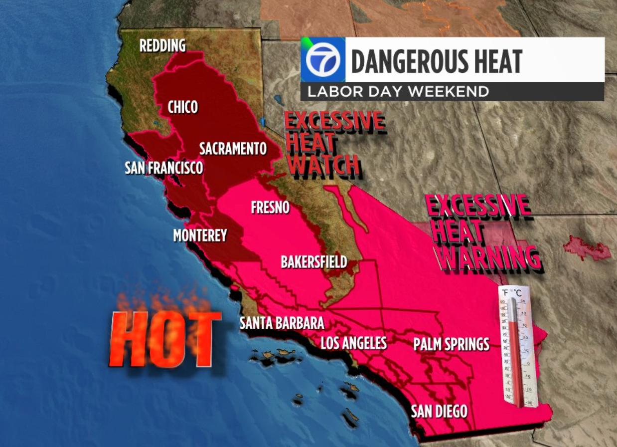
Two recent examples – an intense heat wave that pushed California’s power grid to its limits in September 2022, and the failure of the water system in Jackson, Mississippi, amid flooding in August – show how a growing maintenance backlog and increasing climate change are turning the 2020s and 2030s into a golden age of infrastructure failure.

I am a civil engineer whose work focuses on the impacts of climate change on infrastructure. Often, low-income communities and communities of color like Jackson see the least investment in infrastructure replacements and repairs.

Crumbling bridge and water systems

The United States is consistently falling short on funding infrastructure maintenance. A report by former Federal Reserve Board Chairman Paul Volcker’s Volcker Alliance in 2019 estimated the U.S. has a US$1 trillion backlog of needed repairs.

Over 220,000 bridges across the country – about 33% of the total – require rehabilitation or replacement.

A water main break now occurs somewhere in the U.S. every two minutes, and an estimated 6 million gallons of treated water are lost each day. This is happening at the same time the western United States is implementing water restrictions amid the driest 20-year span in 1,200 years. Similarly, drinking water distribution in the United States relies on over 2 million miles of pipes that have limited life spans.

…click on the above link to read the rest of the article…

Heat Dome Bakes California As “A Lot Of Records Could Be Tied Or Broken”

Heat Dome Bakes California As “A Lot Of Records Could Be Tied Or Broken”

A severe heatwave across California and the Pacific Northwest will test power grids this week and early next week.

Temperatures are forecasted to soar above 100 degrees Fahrenheit east of San Diego and Los Angeles, with areas near Palm Springs and Palm Desert exceeding 113 starting Tuesday, according to the National Weather Service (NWS). By Thursday, Sacramento could reach 105.

The heat dome will spread into Washington, Oregon, and even Montana, Brian Hurley, a senior branch forecaster at the US Weather prediction center, said, quoted by Bloomberg. He outlined:

 “A lot of records are forecast to either be tied or broken,” Hurley said. 

The blast of hot air will peak average California temperatures of around 85-90 degrees Fahrenheit on Sept. 5 and revert to a 30-year trend line of the low 70s by mid-month.

Average high temperatures in California could be near the triple-digit territory.

Californian residents will lower their thermostats to seek relief with air conditioners, boosting electricity demand.

Bloomberg noted demand on the state grid could reach 44.8 gigawatts on Sept. 4 and then stay elevated until the heat dissipates. Peak loads are expected early next week.

On a seasonal basis, California power prices are above a 10-year trend line due to the burst of hot weather.

California’s grid operator has postponed power-plant maintenance from Aug. 31 to Sept. 6 to ensure adequate power supplies.

UK shatters record for its hottest day ever; London fire service declares ‘major incident’

  • Britain recorded its hottest-ever day Tuesday, with temperatures hitting a high of 40.3 degrees Celsius (104.5 degrees Fahrenheit) in the east of England, according to provisional data from the Met Office.
  • London’s fire brigade declared a major incident after a “huge surge” in fires across the capital Tuesday.
  • Millions of Brits endured the country’s hottest-ever night Monday, with temperatures remaining above 25C in places.
People turn out to watch the sunrise at Cullercoats Bay, North Tyneside. Britons are set to melt on the hottest UK day on record as temperatures are predicted to hit 40C. Picture date: Tuesday July 19, 2022.
Owen Humphreys | Pa Images | Getty Images

LONDON — Britain recorded its hottest-ever day Tuesday, with temperatures hitting a high of 40.3 degrees Celsius (104.5 degrees Fahrenheit) in the east of England, as London’s fire service tackled several blazes across the capital.

The provisional figures from the U.K.’s weather service showed Coningsby, Lincolnshire, hit the new high Tuesday afternoon, surpassing two new records set earlier in the day.

The country’s previous hottest temperature was 38.7C, recorded in Cambridge in 2019.

It comes as Brits face the second day of an extreme heatwave, which is causing widespread disruption and raising the risk of wildfires.

“If confirmed this will be the highest temperature ever recorded in the UK. Temperatures are likely to rise further through today,” the Met Office said on Twitter.

Temperatures were forecast to hit as high as 42C in parts of England by Tuesday afternoon, according to the Met Office, which issued a red extreme heat warning. Health authorities urged people to take precautions, including staying indoors and drinking plenty of water.

The country is also on high alert for wildfires, with the southeast of England at “very extreme danger,” according to the European Forest Fire Information System.

…click on the above link to read the rest of the article…

UK Met Office Issues First Red Warning for Extreme Heat

UK Met Office Issues First Red Warning for Extreme Heat

The UK’s Met Office has issued its first ever red warning for extreme heat, as it warned of a “potentially very serious situation” in parts of England that could pose a risk to life.

During the ongoing heatwave that is set to peak on Tuesday, the Met Office said, there is an 80 percent chance of the mercury topping the UK’s record temperature of 38.7C (101.7F) set in Cambridge in 2019, and there is a 50 percent chance of temperatures reaching 40C somewhere in the UK.

The red warning, the first of its kind ever issued, covers an area from London up to Manchester and then up to the Vale of York, said Met Office spokesman Grahame Madge, adding: “This is potentially a very serious situation.”

Penny Endersby, Met Office chief executive, said in a sombre video shared online: “The extreme heat that we’re forecasting right now is absolutely unprecedented.”

“Stay out of the sun, keep your home cool, think about adjusting your plans for the warning period,” she said.

‘National Emergency’

The UK Health Security Agency has increased its heat health warning from level three to level four, which indicates the situation amounts to a “national emergency.”

Level four is reached “when a heatwave is so severe and/or prolonged that its effects extend outside the health and social care system… At this level, illness and death may occur among the fit and healthy, and not just in high-risk groups,” it said.

England’s chief medical officer, Professor Sir Chris Whitty, asked people on Twitter to look out for each other.

…click on the above link to read the rest of the article…

European Power Prices Spike As Heat Dome Strains Grid 

European Power Prices Spike As Heat Dome Strains Grid 

European day-ahead power prices continue to soar for the third day due to an early-season heat wave driving up cooling demand, lack of renewable energy generation, declining nuclear power, and soaring natural gas costs.

Large swaths of Europe over the weekend experienced temperatures above 100 degrees Fahrenheit (38 Celsius). The hottest temperatures were from Spain to Germany to France.

Bloomberg notes power grids were under stress as wind generation in Germany and Italy plunged, forcing the need to increase the capacity of fossil fuel power generators to make up for the lost power. This placed a bid under electricity prices as the cost to generate power soars because of tightening supplies due to declining Russian flows.

“Already high gas prices, combined with low wind output will require less efficient, higher cost gas plants to fire up, pushing up prices,” BloombergNEF’s Andreas Gandolfo said. 

Day-ahead power prices in France traded at 383.14 euros ($404.08) a megawatt-hour, up more than 64% from last week.

Besides tight fossil fuel supplies and a lack of renewable power from Germany and Italy, half of France’s 56 nuclear reactors are offline. France was the biggest net exporter of power last year, supplying many European countries.

French nuclear power is needed when renewable energy is lacking. Also, Brussels’ drive for net-zero carbon emissions and weening off Russian fossil fuels has made the energy crisis on the continent worse.

To avert a more profound crisis, German Vice-Chancellor and Economy Minister Robert Habeck said Sunday that the country is increasing coal generation to increase power output.

The decision comes just days after Russian gas company Gazprom announced that it was reducing supplies through the Nord Stream 1 pipeline for “technical reasons.”

…click on the above link to read the rest of the article…

“Dangerous” Heat Dome Shifts Eastward, Triple-Digit Temps Expected For Southeast

“Dangerous” Heat Dome Shifts Eastward, Triple-Digit Temps Expected For Southeast

A heat dome hovering over the northern Plains has begun to shift eastward early this week, expected to bring triple-digit temperatures across southern and eastern regions of the U.S.

Dangerous heat will continue to make headlines from the central U.S. to the Southeast. One more day of well above normal, near-record and record-breaking heat is expected from the central Plains to the Upper Midwest.

Excessive Heat Warnings remain in effect for the Red River Valley of the North and the greater Minneapolis area. High temperatures up to 100 degrees along with high humidity will lead to head indices into the mid-100s …

“The center of the heat wave begins to transition further east on Tuesday into the Great Lakes, with forecast highs in the mid- to upper 90s, up to 15-20 degrees above normal.

“In addition to hot high temperatures, very warm, near-record and record-breaking low temperatures in the 70s will provide little relief from the heat overnight. Temperatures will also warm up across the Southeast on Wednesday, with highs into the low 100s expectedMaximum heat indices may reach as high as 110 degrees along the central Gulf Coast when factoring in high humidity. High temperatures in general will be hot and a bit above normal across most of the central and eastern U.S. outside of the Northeast and Mid-Atlantic,” the National Weather Service wrote in an early morning weather outlook.  

At 0800 ET, at least nine million people across eight northern and central U.S. states, including Minnesota, Iowa, North Dakota, South Dakota, Michigan, Wisconsin, Nebraska, and Kansas, were under heat alerts. That number should exponentially increase as the heat dome moves eastward.

Summer begins Tuesday, and large swaths of the Central and southern parts of the country could see above-average max temperatures through the end of the month.

Above-average weather will increase cooling demand from households and businesses, may strain power grids, and result in higher electricity costs for tens of millions of Americans, or worst, power blackouts.

Climate change, energy, and an unstable grid: The mainstream belatedly gets the connections

Climate change, energy, and an unstable grid: The mainstream belatedly gets the connections

Memorial Day marks the unofficial beginning of summer in the United States as the temperate breezes of spring give way to an enveloping heat that has become more and more intense each year due to climate change. This summer forecasters are expecting two big things: deadly heat and electricity outages. Mainstream news coverage is now explaining why these are inextricably intertwined, a relatively new development in such coverage. And, it turns out that the recent blistering record heatwave in India and Pakistan is but a foretaste of our future.

Those of us who have covered climate change in the last two decades believed that by the time such connections became obvious and noted by mainstream outlets, the world would be so far along in the process of global warming that stability-challenging events such as grid failures would become normal.

That’s because of the lag time between when we introduce greenhouse gases into the atmosphere and when we experience the warming caused by them is between 25 and 50 years. This is due to what’s called the thermal inertia of the oceans which means more or less that the oceans take time to warm (usually decades). Even if we were to take drastic action now that stopped all further emissions of greenhouse gases, the world would be in for several more decades of rising temperatures. But, of course, we as a global society are instead pursuing business as usual.

I can remember as a child living largely without air-conditioning. We would experience nights so cool at the cottage we rented along the shores of Lake Michigan that we would close all the shutters and cover ourselves with wool blankets.

…click on the above link to read the rest of the article…

Quick Shot Of Heat To Roast 100 Million People In Northeast

Quick Shot Of Heat To Roast 100 Million People In Northeast

About 100 million people in the Northeast will be blasted with a quick shot of heat and humidity this Saturday and Sunday. High temperatures are expected to range between the upper 80s and mid-90s from Ohio to Washington, D.C. to Baltimore to Philadelphia to New York City.

AccuWeather meteorologists say some cities in the Mid-Atlantic and Northeast could see the hottest conditions since last August. In some metro areas, record highs for this time of year that have stood the test of time could be broken.

Daily record highs that have stood since the World War II and Great Depression eras will be challenged at a number of locations. At Philadelphia, temperatures could approach the record of 95 set in 1934 on Saturday. In both Raleigh, North Carolina, and Albany, New York, the daily records for Saturday, May 21, were set in 1941. The record in Raleigh is 96, while the record in New York’s state capital is 91. -AccuWeather

“Early season heat with likely record high temperatures will spread from the South into the Ohio Valley, Mid-Atlantic, and Northeast on Friday, Saturday, and perhaps Sunday,” the National Weather Service said. The agency has issued a Heat Advisory along the I-95 corridor in the Northeast.

It’s the first time since 2006 that a Heat Advisory for New York City has been issued for this time of year. Tomorrow, high temps in Central Park could reach 93 degrees, tying a record for the date. The quick blast of heat comes as temperatures in the urban park between the Upper West and Upper East Sides of Manhattan haven’t even breached 80 degrees yet this year.

“The brunt of it should just be a one-day thing … at the minimum, we will be close to all the records in NYC,” Matt Wunsch, a weather service meteorologist on Long Island, told Bloomberg.

…click on the above link to read the rest of the article…

Texas Power Grid Warns Of Record Demand Amid Back-To-Back Triple-Digit Heatwaves

Texas Power Grid Warns Of Record Demand Amid Back-To-Back Triple-Digit Heatwaves

An early summer heatwave pattern continues to boil parts of the Central and Southern Plains. This means parts of Texas will continue to roast with temperatures forecasted to reach triple digits next week.

The Electric Reliability Council of Texas (ERCOT), the state’s power grid operator, is already warning of record energy demand next week as customers crank up the AC.

Power consultant Doug Lewin, who actively monitors the Texas grid, told FOX 4 News Dallas-Fort Worth that triple-digit temperatures are very concerning because it’s “still not even summer.”

On Tuesday, ERCOT reported power grid demand jumped to 70,703 megawatts, smashing the May 2018 record demand of 67,271 megawatts due to an early week heatwave. Now the next round of heat has the power grid operator concerned.

ERCOT issued an operating conditions notice (OCN) for extremely hot weather. The OCN begins on Friday and lasts through next Wednesday. The grid operator ensured customers it had enough power to meet the demand spike.

The National Weather Service’s Austin/San Antonio office warns that “more triple-digit heat is in store for early next week.”

High temperatures across the Dallas/Fort Worth areas are expected to flirt with triple digits on Sunday through next week.

Back-to-back heatwaves hitting parts of Texas when power plants usually go offline for maintenance is concerning, though the latest from ERCOT is that they have everything under control.

First Look At Tornado Damage In New Orleans; 1000s Without Power

First Look At Tornado Damage In New Orleans; 1000s Without Power

As the sun comes up Wednesday morning in New Orleans, many folks are waking up to vast amounts of destruction after a tornado touched down on Tuesday night.

Local news WDSU reports a tornado ripped through parts of St. Bernard Parish, which borders New Orleans to the southeast. It demolished homes and businesses, flipping vehicles and killing at least one person.

Rescuers have been working non-stop, searching through the suburban parish for missing people. St. Bernard Parish President Guy McInnis said the tornado caused widespread damage.

“A tornado touched down this evening in the Lower Ninth Ward and New Orleans East communities shortly before 8 p.m. CST. The New Orleans Office of Homeland Security & Emergency Preparedness has activated the Emergency Operations Center in response to the tornado. As of now, there have been no reports of casualties or significant damage to Orleans Parish,” said Mayor LaToya Cantrell.

“Our partners at Entergy are working to restore power to the 8,000 customers impacted. Residents should avoid all travel that isn’t essential, to provide an opportunity for the professionals to handle this situation,” Cantrell said. 

Fox News’ Mitti Hicks posted heartbreaking images of the destruction from St. Bernard Parish.

Another first look at the tornado damage.

Australia Ties Record for Hottest Southern Hemisphere Day

Australia Ties Record for Hottest Southern Hemisphere Day

It topped 123 degrees Fahrenheit in Western Australia, tying the record for the hottest temperature ever recorded in the southern hemisphere

A map showing the misery index in Australia on Thursday.
Gif: Earth Wind Map

It is really, really, really hot in Australia right now.

On Thursday, Onslow, a coastal town in Western Australia north of Perth, recorded a high temperature of 123.3 degrees Fahrenheit (50.7 degrees Celsius). That sweltering heat ties the record for the hottest temperature ever recorded in the southern hemisphere, which was set in 1960 in the South Australia outback.

While Onslow was the hottest spot on the continent on Thursday, it wasn’t alone in suffering through the heat. The nearby towns of Roebourne and Mardie both recorded temperatures of 122.9 degrees Fahrenheit (50.5 degrees Celsius), both of which are records as well. Before this week, Australia has only crossed the 122-degree-Fahrenheit (50-degree-Celsius) mark three times in its history. Now, it’s happened at three locations in one day—and even more intense heat is on the way.

Luke Huntington, a meteorologist at Australia’s Bureau of Meteorology, told local outlet WA Today that the dry spring the area has had could be contributing to the record-setting temperatures—and that this trend could continue.

“The Pilbara region has had persistent hot temperatures over the last few months. and there has been no rainfall to really take away the hot air that has built up,” he said. “Over the next few months. there is a high chance that temperatures on a day-to-day basis will be above average, at least until the wet season rains hit properly.”

…click on the above link to read the rest of the article…

Olduvai IV: Courage
Click on image to read excerpts

Olduvai II: Exodus
Click on image to purchase

Click on image to purchase @ FriesenPress