Home » Posts tagged 'snow'

Tag Archives: snow

Olduvai
Click on image to purchase

Olduvai III: Catacylsm
Click on image to purchase

Post categories

Post Archives by Category

Entire Season Of Snow Could Dump On Texas Panhandle; Pipeline Operators Warned About ‘Freak Storm’

Entire Season Of Snow Could Dump On Texas Panhandle; Pipeline Operators Warned About ‘Freak Storm’

One of the snowiest spots in the country during the Thanksgiving holiday is a very unlikely place: the Texas panhandle.

Weather Underground provides two forecasts: the EURO Model beating the GFS Model regarding how much snow accumulation is expected across the Texas panhandle.

The EURO model expects 12-18 inches for a large swath of the state’s northernmost part, consisting of 26 counties. In Amarillo, forecasts show 18-24 inches.

The GFS model isn’t as severe, with a large swath of the region forecasted to receive 8-12 inches with pockets of 12-18 inches south of Amarillo.

Meteorologist John Homenuk tweeted: “The TX Panhandle needs precipitation, but I can’t say this is how I envisioned them getting it in the short term.”

Homenuk tweeted snowfall forecasts through Saturday that show much of the Texas panhandle will expect accumulating snow.

“The combination of high winds and heavy wet snow through Thursday night into Friday will create whiteout conditions which will make travel extremely dangerous,” local news ABC 7 said.

According to the National Weather Service, Texas Panhandle averages 17 inches of snow throughout the winter. If the weather models hold up, some areas could receive an entire year’s worth of snow in the next few days.

This is undoubtedly a ‘freak’ event but not unexpected, as we noted on Nov. 7 that “Frigid Weather Set To Swoop Across Country.”

The Texas Railroad Commission warned oil and gas operators across the Midland-Odessa and Panhandle regions about wintry precipitation through Friday.

The devastating cold snap of early 2021 is still fresh in the minds of millions of Texans.

Arctic Blast Could Produce Next Snowmaker For Northeast

Arctic Blast Could Produce Next Snowmaker For Northeast

Freezing temperatures will return to the central and eastern regions of the US this week as an arctic front sweeps out the mild weather. This could result in the next snowmaker for parts of the mid-South and Northeast by Tuesday afternoon into Wednesday, reported The Weather Channel

The jet stream will dive southward over the central and eastern states as a cold front slides through the Plains, Midwest, and into the East during the day. The frigid weather will first affect the Northern Plains and the upper Midwest on Tuesday. Highs will be around zero through mid-week for parts of Dakotas, Minnesota, Wisconsin, and Michigan.


🥶

Cold temperatures will impact the Northern Plains and Upper Midwest this week. The combination of arctic air and brisk winds could lead to dangerous wind chills.

View image on Twitter

The cold front will continue the march southward into the evening and overnight. Arctic air is expected to collide with moisture in the mid-South and Northeast by the afternoon into evening hours, which could change from rain to snow. 

The change over could occur in rush hour for parts of central Arkansas to northern Mississippi, western and Middle Tennessee, southern Kentucky, and West Virginia.

…click on the above link to read the rest of the article…

Plastic Apocalypse: Dangerous Microplastics Invade Alps To Artic, Found In Fresh Snow

Plastic Apocalypse: Dangerous Microplastics Invade Alps To Artic, Found In Fresh Snow

A new study has revealed that high levels of microplastics have been detected in some of the most remote regions of the world.

The discovery, published in the journal Science Advances, is the first international study on microplastics in snow, conducted by the Alfred Wegener Institute in Germany.

Melanie Bergmann, the lead scientist, and her team of researchers found microplastics from the Alps to the Arctic contained high levels of the plastic fragment, raises questions about the environmental and health implications of potential exposure to airborne plastics.

Watch: Farmers create natural straw intend to break plastic’s back

“I was really astonished concerning the high concentrations,” said co-author Gunnar Gerdts, a marine microbiologist at the Alfred Wegener Institute.

Bergmann explains that microplastics come from industrial economies where rubber and paints are used. The tiny fragments end up in the sea, where they’re broken down by waves and ultraviolet radiation, before absorbing into the atmosphere. From there, the plastic particles are captured from the air during cloud development, can drift across the Earth via jet streams. At some point, the particles act as a nucleus around supercooled droplets can condense, and travel to Earth as snow.

“Although there is a huge surge of research into the environmental impact of plastics, there is still so much that we do not know,” said Bergmann.

Bergmann noted how the scientific community was only in its infancy of examining the process of how microplastics get sucked up into the atmosphere then scattered around the world in some form of precipitation. She said, there’s an “urgent need for research on human and animal health effects focusing on airborne microplastics.”

 …click on the above link to read the rest of the article…

Europe Inundated by Snow Down to Greece & Harvard Study Shows Oceans Are Getting Colder

This winter is once again extremely brutal in Europe. Extremely heavy snow has fallen as far south as Greece in the range of even 3 to 5 feet in various places. This is the third year of extreme cold in Europe which has been fueling more resentment about global warming taxes. Once again, Europe has been thrown into economic chaos for much of the region is not able to cope with snow lacking the historical experience.

Meanwhile, scientists have revealed that the oceans are still getting colder at deeper levels in a slow-moving trend that was set in motion by the last Little Ice Age. The idea that the oceans have been retaining the heat so that is why the planet has not warmed up as forecast 30 years ago flies in the face of those ideas as well.

Sierra Nevada Snowpack On Track To Collapse 79%, New Study Warns

A new report by the Department of Energy’s Lawrence Berkeley National Laboratory (Berkeley Lab) examined the headwater regions of California’s ten major reservoirs, representing half of the state’s surface storage, discovered each could experience a 79% decline in peak snowpack water volume by 2100.

Berkeley Lab used supercomputers to investigate current warming trends and carbon emissions.

Scientists analyzed how a future warmer world would affect “snowpack upstream of 10 major reservoirs — three in Northern California, three in Central California, and four in Southern California. The reservoirs are Shasta, Oroville, Folsom, New Melones, Don Pedro, Exchequer, Pine Flat, Terminus, Success, and Isabella,” said The Mercury News.

By 2039 to 2059, the snowpack runoff could drop by 54%, the study determined, and then 79% from 2079 to 2099. The study noted that three northernmost reservoirs, Shasta, Oroville and Folsom, could see an 83% reduction, by 2100.

Alan Rhoades, a postdoctoral fellow at Berkeley Lab and lead author of the study, said his team of researchers found that peak runoff could come four weeks earlier by 2100, at the beginning of March rather than April 01.

Mountain snowpack is a significant source of water for California: “Our precipitation is really intermittent and extremes-driven,” Rhoades said. “We get 50% of our annual precipitation in five to 15 days, or one to two weeks. Our water demand is highest during the summer months when we don’t get a lot of precipitation, so we really rely on mountain snowpack as a stopgap for our water supply.”

“So as the world continues to warm, these storms will get even warmer and won’t readily get to freezing, whereby you could have snowfall or snow accumulation and the persistence of snow on the surface,” he said.

As a result of warmer weather, the amount of snow is projected to decrease while rain could increase. The study noted that it did not look at rainfall, only mountain snowpack.

 …click on the above link to read the rest of the article…

Weather Channel: “It’s Been One Of The Most Miserable Starts To Winter On Record” 

Across the Northeast, Midwest, and Plains, it has been one of the coldest and snowiest starts to the winter season on record.

“Winter has gotten off to a fast start across a majority of the United States, particularly across the Northeast. Early season snow plagued I-95 in mid-November, bringing New York City it’s earliest 6” snowfall on record. Record cold blanketed the region on Thanksgiving, partly causing a rapid spike in natural gas prices. Cold also likely played a role in retail performance over the holiday weekend. While most see a reprieve from cold over the next 7 days, another blast of arctic air is expected later in the first week of December across the eastern U.S., which may further complicate energy market movement going forward,” said Ed Vallee, head meteorologist at Vallee Weather Consulting.

Central New York, the Baltimore–Washington metropolitan area, and much of the Rust Belt have already reported one of the snowiest starts to November in decades.

According to the Accumulated Winter Season Severity Index (AWSSI) also known as the “Winter Misery Index” from the Midwest Regional Climate Center, 74 metro areas from New England to the Plains and Rockies have experienced cold and snow that generally would not occur until January.

AWSSI index computes the “intensity and persistence of cold weather, the frequency and amount of snow and the amount and persistence of snow on the ground (wind and mixed precipitation are not a part of the index),” the Midwest Regional Climate Center said.

The weather index uses five categories – mild, moderate, average, severe and extreme – to assess the severity of winter weather in a particular region.

…click on the above link to read the rest of the article…

El Nino Threatens North America In New Weather Report – “Big East Coast Systems Capable Of Snow”

El Nino conditions are quickly developing across the central and eastern equatorial regions of the Pacific Ocean, with meteorologist now indicating a high chance of development by December.

Warmer-than-normal temperatures for most of the country are expected, according to NOAA’s Climate Prediction Center’s official winter weather forecast released Thursday.

Current models show El Nino has a 70 to 75% probability of forming. “We expect El Nino to be in late fall to early winter,” Mike Halpert, deputy director of NOAA’s Climate Prediction Center. “Although a weak El Nino is expected, it may still influence the winter season by bringing wetter conditions across the Southern United States, and warmer, drier conditions to parts of the North.”

El Nino is a massive ocean-atmosphere climate event linked to a periodic warming in sea surface temperatures across the central and east-central Equatorial Pacific waters.

The swings between warmer and cooler waters in the tropical Pacific are the primary factors for either El Nino (warmer seawater) or La Nina (cooler seawater), which government meteorologist watch closely in determining the North American winter weather forecast.

Here is the 2018 U.S. Winter Outlook report (Dec. through Feb): 

Warmer-than-normal conditions are expected across much of the northern and western U.S., with higher probabilities of warmer temperatures in Alaska and from the Pacific Northwest to the Northern Plains, Halpert said in a statement.

The forecast does not show any region in the US below-average temperatures for the season. Much of the Southeast, Mid-Atlantic, and Ohio Valley regions will remain within average ranges.

Halpert said wetter-than-average conditions are favored across the southern tier and Mid-Atlantic, with the highest odds for above-average precipitation in northern Flordia and south Georgia.

…click on the above link to read the rest of the article…

September the Coldest Month in a Decade – Must be Global Warming

It is not looking very good for the winter ahead. A reader from Calgary sent this picture in about the early snowfall up there. Indeed, Calgary just experienced the Snowiest Day in More Than Three Decades. It Broke an October Snowfall Record. Of course, they will call this Global Warming as well. This is just a taste of this winter to come.

Already, the data is now in for September. The world just had the coldest September for a decade, according to the latest satellite measurements by the University of Alabama at Huntsville.  Naturally, mainstream media will not cover this story. They only like to report how we are destroying the planet and everything is all our fault.

Since the governments have handed out $1 billion for these people to create Global Warming forecasts to justify more taxes, there is not a cold day in hell why they would even give us $5 for a correlation study that shows the opposite. Why fund something that does not produce more taxes?

Well, besides growing food in your basement, perhaps you should buy a sewing machine to make long-underwear to sell to the neighbors when they realize it’s getting colder rather than warmer.

The Death of Sunspot Cycle 24, Huge Snow and Record Cold

The Death of Sunspot Cycle 24, Huge Snow and Record Cold

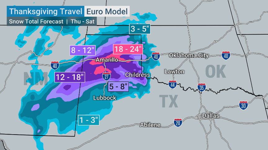
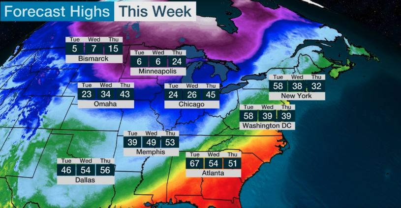
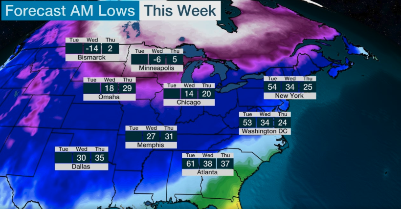
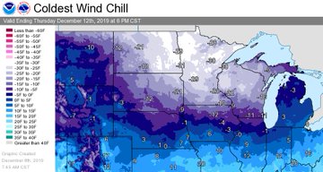
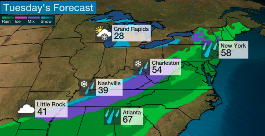
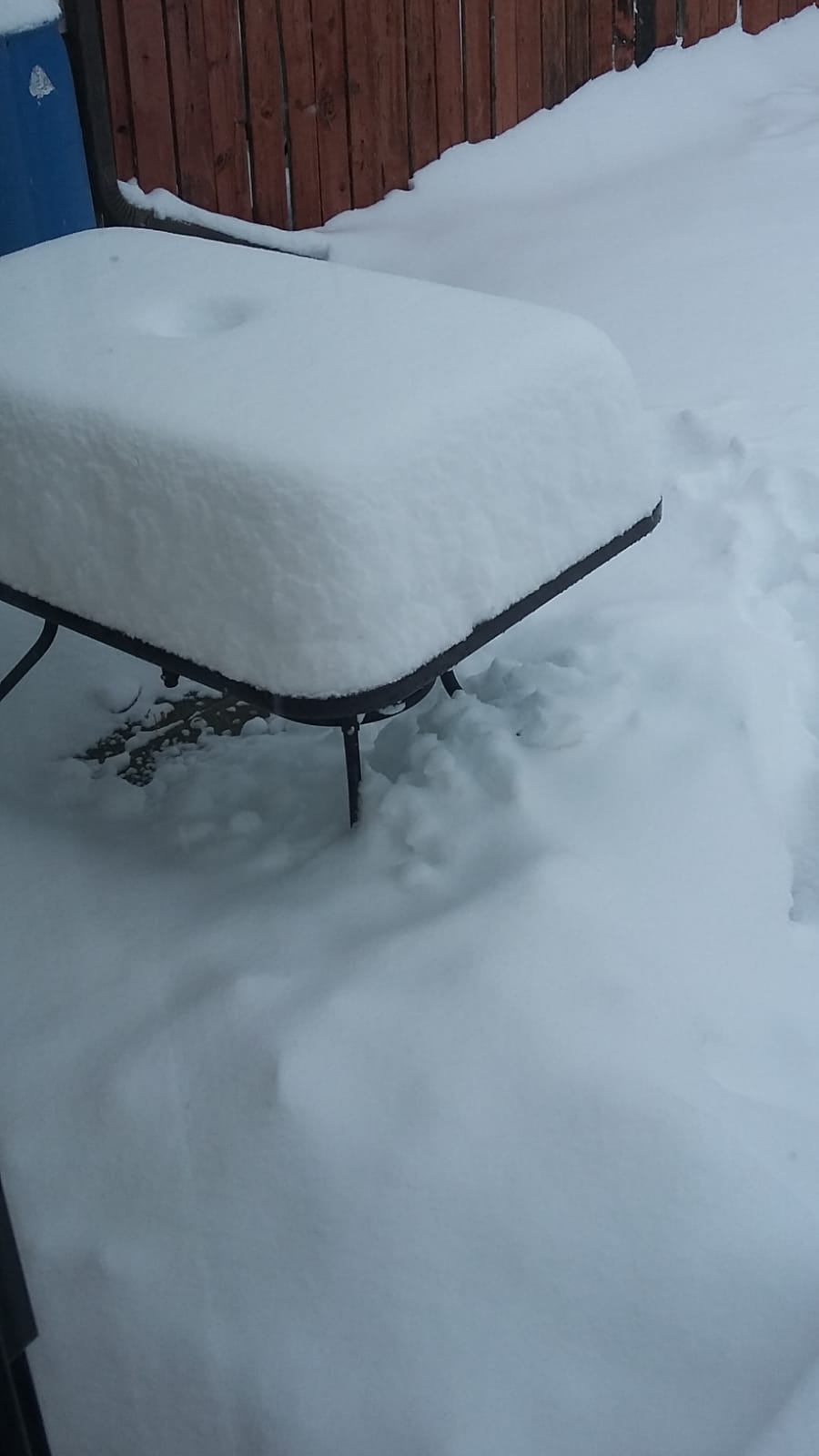
My friend Alex is in Chamonix in the shadow of Mont Blanc in the French Alps. He sent some very snowy pics and mentioned that it was fair dinging down. The most snow since 2010. Knowing that sunspot cycle 24 was well-advanced I did some checking and came across a web site called Weather to Ski that had some amazing pics of big snow. One picture in particular caught my attention. See inset and below the fold.

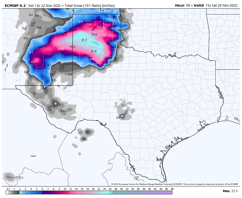
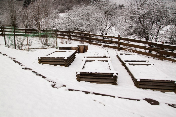
Figure 1 Huge snow depth in the Alps. It is possible that the snow depth here is influenced by the road, snow blowers piling snow up along the route, and also drifting snow getting trapped in the ravine. But still, 8m is a lot. A cross country skier would be confronted with enormous difficulty crossing this road.

It looks like the snow in this drift is ~ 8m deep. And this is in the valley, not in the high basins where the snow fields that feed the glaciers lie. Now it’s obviously far too early to begin to draw any conclusions. But IF we get a run of 3 or 4 winters that dump this much snow, it is not inconceivable for me to imagine Alpine glaciers once again beginning to advance. I’m totally unsure how long it takes for pressure in the glacier source to feed through to advance of the snout.

So what is going on? We’ve been told by climate scientists that snow would become a thing of the past. We’ve also been told that global warming might lead to more snow and less snow. And we’ve been told that warming might even lead to cooling.

…click on the above link to read the rest of the article…

4 Big Ways Snow Can Benefit the Garden  

4 Big Ways Snow Can Benefit the Garden  

All of the snow accumulation from the extreme temperatures occurring through the country could be doing your garden some good. That right, folks snow is great for the garden!

Snow insulates plants and trees

Snow cover protects plants from harsh, drying winter winds which can freeze the ground and damage the root systems of shrubs and trees. In fact, without snow, cold weather could freeze the soil and further damage root systems in trees. You could say that snow it acts like an insulating blanket, and in wintertime, who doesn’t want an insulating blanket to stay warm? It works by trapping pockets of air that hold in heat for the plants. Mother Nature is a wondrous thing!

Beneath one foot of snow, the soil and the organisms within it are protected from changes in the air temperature above the snow surface. The moist surface of snow influences how much heat and moisture circulate between the ground and the atmosphere. For every inch of snow, you get 1 R-value of insulation. (R-value is a way to measure insulation). Although the R-value can vary with the type of snow, you can get a good idea of how insulating this really is to the garden.

Snow adds nutrients to the soil in the spring

The University of New Hampshire’s Department of Natural Sciences states that snow contains nutrients that penetrate into the soil and does some good for the plants that will grow in that soil later on in the year. Nutrients include nitro­gen (most prevalent), along with some sulfur and other trace elements. Studies even claim there are more of these nutrients bound up in snow than in the corresponding amount of rain.

Snow adds a slow release of moisture

…click on the above link to read the rest of the article…

The Entire East Coast Needs to Get Ready for “Snow Bombogenesis”

The Entire East Coast Needs to Get Ready for “Snow Bombogenesis”

We’re starting the New Year off with a bang in the form of Winter Storm Grayson. The next weather threat heading our way is a phenomenon called a “bombogenesis.” This occurs when a system’s central pressure plummets dramatically — “24 millibars or more — in 24 hours” according to Bloomberg.

Basically, it’s a hurricane. A winter hurricane.  The same high winds (up to 80 mph) and the same precipitation, but with snow instead of rain.

Because what could be more exciting than a hurricane and a blizzard all rolled into one kick-bootie storm?

The entire East Coast is at risk, from the northern part of Florida all the way up into Canada. The Southern US will get some snow and wind on Wednesday, and New England will be hit hard on Thursday.

…ice has already formed on fountains in some southern cities, including Savannah, Georgia, and Charlotte, North Carolina.

In northern Florida and southern Georgia, a dangerous mix of snow and ice are in the forecast for Wednesday morning.

Residents of cities including Tallahassee, Florida, and Valdosta, Georgia, may see up to an inch of snow on the roadways during the Wednesday morning commute…

Through Wednesday the low pressure will ride up the East Coast, bringing a wintry mix of snow and ice through Georgia, South Carolina, and North Carolina.

Georgia and the Carolinas may see 1 to 3 inches of snow…

The storm will strengthen as it moves north overnight Wednesday. By Thursday morning, there will be heavy snow across the Mid-Atlantic coast, including Philadelphia and the New Jersey shore.

The Mid-Atlantic is forecast to have about 3 to 6 inches of snow, with lower amounts inland and higher amounts near the coast.

The snow will continue north Thursday. Long Island and New England — especially Maine — may get over 6 inches of snow. (source)

…click on the above link to read the rest of the article…

Last record-breaking winter with snow hits Canada, US, before “nobody knows what snow is”

Last record-breaking winter with snow hits Canada, US, before “nobody knows what snow is”

UPDATE: Record breaking snow falling in upstate New York. Pennsylvania.

The airport in Erie, Pennsylvania, has had a whopping 65.1 inches of snow from this lake effect event — the highest snowfall total from any event on record in Erie. (Heavy lake effect snow is produced by cold Arctic air moving over relatively mild water temperatures in the Great Lakes.) — World News, ABC (US) News

40,000 people in Cleveland lost power overnight.

New York City may have coldest New Year’s Eve since 1960s… — ABC News

In freak conditions, Canadians (and many people in the US too) are getting a chance to enjoy record cold for the last time before climate change makes winters unbearably mild.

Extreme cold in Toronto smashes 57-year-old temperature record

Temperatures observed at Toronto’s Pearson International Airport bottomed out at -22 C [-7.7F]  this morning. The previous record for this date was set in 1960, when it hit -18.9 C. [-2F]

Tristan Hopper does some first class bragging about the cold:

Mars and the North Pole are warmer than Winnipeg: A guide to how damned cold it is

Vancouver is as cold as Moscow, Toronto is colder than CFS Alert and a piece of the country roughly the size of Europe was under an extreme cold warning

It’s colder in Winnipeg than it has ever been in Scotland (ever)

The coldest ever in Scotland was apparently only – 27C. (-16.6F). And for southerners, “CFS Alert” is the worlds most northern inhabited place, deep into the Arctic, and beyond even where Inuits would live. Today, by the way, in midsummer the South Pole warmed up to -18C.

A swath of Canada the size of Europe was under an extreme cold warning

Alberta’s warmest place was almost as cold as Mars

…click on the above link to read the rest of the article…

Snowmageddon Dumps Record 60 Inches Of Snow On Erie, PA; “Declaration Of Disaster”

Snowmageddon Dumps Record 60 Inches Of Snow On Erie, PA; “Declaration Of Disaster”

On Tuesday, the city of Erie, Pennsylvania signed a declaration of disaster emergency, after a two-day storm dumped 5-feet of snow. Heavy lake-effect snow set record-setting snowfall totals in the snow belts to the east of Lake Ontario and Lake Erie.

From 7 p.m. on Dec. 24 to 6:02 p.m. Dec. 26, Erie had received 60.0
inches of snow, which shattered numerous records for the region. Nearly
all of the snow fell on Monday and Tuesday.

AccuWeather Meteorologist Bill Deger said, “this is now the biggest two-day snow total on record for Pennsylvania, besting the old record of 44 inches, which was set in Morgantown from March 20-21, 1958.”

Dale Robinson, the county’s emergency management coordinator, said that the declaration will allow the National Guard to respond to the paralyzed region. Robinson adds the National Guard deployment is “really for precautionary measures for the additional amount of snow we think we’re going to get.”

Images posted on social networks showed a world covered in several feet of snow: 


Erie, PA: One resident’s house is barely recognizable with over 5-feet of snow.


Erie, PA: Brave man dreams about baseball in the chest-high snow.


Erie, PA: Resident is trapped within the home upon opening the door to over 5-feet of snow.

…click on the above link to read the rest of the article…

Is A Major Winter Blast Coming To The East Coast This Christmas?

Is A Major Winter Blast Coming To The East Coast This Christmas?

According to Michael Clark, a private weather forecaster, his latest report indicates a major winter storm is headed for the East Coast between Dec 20, 2017 through Jan 04, 2018

As BAMWX.com notes, the pattern is about to change in a huge way and it may begin on #Christmas eve! Accumulating snow is on the table between Dec 24th-Jan 5th in a big way.

Of course, if a storm erupts, it is the perfect excuse for lagging spending… despite the tax cut windfalls…

Kitamaat Village evacuated after 3 days without power due to near record snowfall

Kitamaat Village evacuated after 3 days without power due to near record snowfall

Residents had to cut through fallen trees with chainsaws to gain road access

B.C.’s Haisla First Nation ordered the evacuation of Kitamaat Village and its 800 residents on Saturday night, three days after the community lost power following a major snowstorm.

Many residents are staying at the Kitimat Riverlodge Leisure Centre, about 15 kilometres north in the town of Kitimat.

Others are staying with family and friends.

The small towns of Kitimat and Terrace were hit with heavy snow earlier this week — nearly two metres of snow from a Pineapple Express weather system was dumped on the region.

The record for a 24-hour snowfall, set on Feb. 5, 1961, was 112 cm. Weather officials say Kitimat came close with 109 cm of snow in a 24-hour period.

Evacuation ordered over Facebook

In a notice posted to Facebook on Saturday, Haisla First Nation chief councillor Ellis Ross warned of a short timeline for the Sunday morning evacuation — the road in and out of the village would be open for just three hours.

“If you have the means to get to town or somewhere else besides Kitamaat Village, please be gone before 8 a.m. PT. Anytime after 8 a.m., don’t even try. The crews will be working and there will be no traffic allowed,” the notice said.


…click on the above link to read the rest of the article…

Olduvai IV: Courage
Click on image to read excerpts

Olduvai II: Exodus
Click on image to purchase

Click on image to purchase @ FriesenPress