Home » Posts tagged 'polar vortex'

Tag Archives: polar vortex

Olduvai
Click on image to purchase

Olduvai III: Catacylsm
Click on image to purchase

Post categories

Post Archives by Category

Will The Texas Power Grid Survive Next Week’s Polar Vortex?

Will The Texas Power Grid Survive Next Week’s Polar Vortex?

The National Weather Service’s Climate Prediction Center forecasts extreme cold weather “across the heart of the country this weekend and is expected to continue into next week.” We previewed this cold blast in a note titled Gobsmackingly Bananas”: Weather Models Predict Polar Vortex Invasion Into US.

Whenever cold air spills south from Canada into the Heartland, attention usually shifts to Texas.

Next, power demand forecasts from the Electric Reliability Council of Texas, the power grid operator for Texas, are analyzed to see if demand forecasts exceed supply. Current forecasts show ERCOT faces the first major test of grid stability for the new year.

And this:

ERCOT has warned its 26 million Texas customers about the upcoming cold blast this weekend into next week. The grid operator assures customers, “Grid conditions are expected to be normal, and ERCOT expects to have sufficient supply to meet demand.”

Energy-focused research firm Criterion Research told clients in a note Wednesday that ERCOT will likely survive the big cold shot:

 ERCOT has issued an Operating Condition Notice (OCN) for the upcoming cold weather event forecast from January 15-17, 2024. The OCN is the first of four levels of communication provided by the agency ahead of a possible Emergency Condition – the following three levels would be Energy Emergency Levels 1 through 3.

ERCOT’s current forecast run shows extreme demand conditions starting on Tuesday, January 16, 2024. That includes a projected peak load of 85,587 MW at 7 AM that morning. However, renewable generation from wind and solar are expected to help out as demand pushes to a seasonal record, with early morning wind + solar contribution 14,137 MW.

…click on the above link to read the rest…

A “Textbook” Sudden Stratospheric Warming Event Appears To Be Unfolding

A “Textbook” Sudden Stratospheric Warming Event Appears To Be Unfolding

Meteorologists on social media channel X are posting weather models about the increasing threat of a so-called sudden stratospheric warming (SSW) over the Arctic, which could unleash wintry weather across the eastern half of the US in the new year.

“A textbook sudden stratospheric warming event looks to be unfolding,” private weather forecaster BAM Weather (BAMWX).

Judah Cohen, Ph.D. and an atmospheric and environmental scientist who studies the polar vortex, told FOX Weather an SSW event takes “about two weeks for the effects of the sudden stratospheric warming to impact our weather.”

Cohen expects that cold air will pour into the Lower 48 in the new year, although the specifics of the event remain uncertain.

Yale Climate Connections wrote in a recent note, “The odds of a snow-favoring East Coast cold wave will be boosted if a sudden stratospheric warming happens to develop in January.”

“Sudden stratospheric warmings involve a rapid and dramatic rise in temperature — as much as 80 degrees Fahrenheit — within the polar stratosphere, together with a disruption in the stratospheric polar vortex. That disruption typically either splits the vortex or pushes it southward, along with associated Arctic air masses,” the weather service ran by Yale Center for Environmental Communication. And it’s the splitting of the polar vortex that delivers the blast of Arctic air to the Lower 48 region.

Cohen posted, “All models now agree on a Polar Vortex stretch. Major warming still possible.”

Meteorologist Mark Margavage said, “The 12z EPS Control run is showing the granddaddy of all Polar Vortex disruptions with a major Sudden Stratospheric Warming Event and split of the PV. This would be the most impactful scenario of the 4 presented today.”

https://www.zerohedge.com/weather/textbook-sudden-stratospheric-warming-event-appears-be-unfolding

Mount Washington Observatory As Cold As Mars With Record-Breaking Wind Chill

Mount Washington Observatory As Cold As Mars With Record-Breaking Wind Chill

The polar vortex that moved in yesterday has been nothing short of impressive. Records were broken at the Mount Washington Observatory (MWObs) in New Hampshire’s White Mountains.

At 6,288 feet, MWObs is located at the highest peak in the Northeast and has some of the most wicked weather in the world.

The lowest-ever wind chill was recorded early Saturday morning near -109 degrees Fahrenheit, surpassing the previous record of -103 degrees. At the same time, temperatures were around -47 degrees.

“There is half of me that loves what is going on right now, and the other half of me is pretty terrifying,” meteorologist Francis Tarasiewicz, stationed at MWObs, told NBC 10 Boston

Here’s a live feed from MWObs.

For some reference, Mars averages about -81 degrees. So the temperatures at MWObs are out of this world.

Recall Friday, we noted that the polar vortex weakened and would pour the coldest air in the world into New England.

Here’s a snapshot of temperatures around 0800 ET via Ambient Weather data.

The National Weather Service in Boston said record cold was achieved at 3 out of 4 weather stations.

Brr, it’s freezing in Boston.

As well as in NYC.

There is some good news. The cold shot across the Lower 48 will only be brief, and above-average temperatures are forecasted for next week.

Meanwhile, legendary Punxsutawney Phil saw his shadow on Thursday, which means the possibility of six more weeks of winter.

Siberia Records Minus-80 Degrees As Talk Of Polar Vortex Grows

Siberia Records Minus-80 Degrees As Talk Of Polar Vortex Grows

Several weeks after the Christmas Arctic blast, much of the US and Europe have enjoyed record warmth. Recall on Dec. 27, we noted the cold air mass from Siberia that spread across the continental US would dissipate into the new year. So far, this is correct, as three weeks of above-average weather has staved off an energy crisis in the Northern Hemisphere. But just north, in Siberia, temperatures are sinking to near-record lows. And it could only be a matter of time before the giant cold air mass swirling in the North Pole becomes unstable, breaks down, and begins pouring into the US and Europe.

Global warming alarmists who called for an imminent climate disaster last summer are scratching their heads as the rural northern Siberian town of Zhilinda just recorded temperatures of minus-79.8 degrees, according to climatologist Maximiliano Herrera, who tracks extreme temperatures across the globe.

Herrera told The Washington Post that Zhilinda was just a few degrees off from breaking its record low of minus-82.3 degrees. The all-time low for the Northern Hemisphere was set in Russia in 1933 at minus-89.9 degrees.

Earlier this week, Arcfield Weather’s Paul Dorian said winter isn’t over and called for a significant change in North American weather “in about ten days or so.” Like anything, nothing is ever constant, and the warm spell could give way to colder temps later this month or early February.

“Sometimes, exceptionally cold air that builds over Siberia spills into the eastern United States,” WaPo explained, adding:

“Although the eastern United States has had very mild weather since that late December cold blast, there is the potential for a significant pattern change toward the end of January.”

…click on the above link to read the rest…

“Potential Polar Vortex Event” Could Spark Bullish Reversal In NatGas 

“Potential Polar Vortex Event” Could Spark Bullish Reversal In NatGas 

Since mid-October, U.S. natural gas futures have been beaten down 40% as the narrative of colder weather and tight supplies quickly flipped and crushed bullish traders. As the Northern Hemisphere winter is less than two weeks away, new weather models suggest “significantly colder” temperatures could return for parts of the U.S. later this month into early 2022.

Meteorologists at private weather forecasting firm BAMWX expect a bullish setup for natgas futures. They say the narrative is flipping from warmer weather to the complete opposite as an Arctic polar vortex could plunge parts of the U.S. into a much colder weather pattern in January than today’s currently mild, above-trend temperatures.

“Seeing an interesting pattern developing ahead leading up to Christmas and into early January ’22, as higher pressure looks to finally re-establish towards Alaska and the North Atlantic, pushing cold from the Arctic down into the US (after a record warm start to the month). If the MJO (Madden-Julian Oscillation) can continue to progress through phase 7 into 8 (and possibly into 1) mid to late December, this can also increase the potential for a Polar Vortex displacement event, sending more consistent cold air deeper into the US…a big risk to watch for the energy markets ahead,” Kirk Hinz, the chief meteorologist at BAMWX, noted. 

BAMWX outlines now could be the time to find a long entry into natgas futures, or as they put it, “long UNG,” the United States Natural Gas Fund, LP. ETF. Their reasoning behind the play is quite simple:

Long UNG Equity, Why? Polar Vortex Jan 2022 Northeast – Front-month NG1 40% drawdown in 6 weeks – Things can change on a dime but the setup is very good in our view – When you get a nice – healthy- capitulation …

…click on the above link to read the rest of the article…

Signs The Worst Winter in Years is Coming

Signs The Worst Winter in Years is Coming

“You think winter will never end, and then, when you don’t expect it, when you have almost forgotten it, warmth comes and a different light” – Wendell Berry.

It’s hard to think about winter when many regions are broiling in the sun right now, but there are enough indicators out there that this winter may be particularly brutal.  We may have another record-breaking winter in the northern hemisphere.  Scientists, climatologists, and meteorologists are all reporting a perfect storm of conditions coming together to brew up a winter as we have never seen before.  In this video, I will explain these conditions as best that I can.  I am not a meteorologist, by any means, but I can follow the science enough to know that if you’re in Europe or the United States, you should be paying attention.

And, as I have shown in other blogs, our aging infrastructure isn’t equipped to handle the extended periods of extreme cold that are currently being predicted.  Just ask anyone in Texas about that, as almost the entire state was left without power for many days this past February due to the extreme cold.  Ice on sagging power lines and frozen pipes could result in an outage that can quickly escalate to a disaster for many.

At the end of this video, I will give you a warning I would encourage you to heed.  But for now, here’s why this winter might be especially brutal…

POLAR VORTEX

The first piece of this colder than average weather prediction is the polar vortex.  A polar vortex is a low-pressure, vast expanse of swirling cold air that is parked in the polar region…

…click on the above link to read the rest of the article…

Spanish Energy Markets Roiled Amid Chilling Temps

Spanish Energy Markets Roiled Amid Chilling Temps

A cold snap across Spain is expected to last through mid-January has resulted in natural gas prices more than doubling in the last week, according to Bloomberg.

LNG prices trading at Spain’s Punto Virtual de Balance (PVB) gas trading hub hit a record 51.55 euros ($63.13) a megawatt-hour this week, or $18.54 per million British thermal units as the nation grapples with dangerously cold weather and snowfall in Madrid.

Spain has one of the largest LNG terminals in Europe. “Surging prices, coupled with a lack of available LNG vessels for longer journeys between Europe and Asia, will probably limit cargo exports from the nation’s ports and further tighten the supply of the fuel,” Bloomberg noted.

Frigid weather in China has resulted in surging LNG prices as well. This week Beijing meteorological station recorded one of the coldest temperatures in decades this past week, sending power demand through the roof. LNG imports in China last month were at record highs as demand to heat homes has surged.

A possible theory behind the wicked cold weather could be the sudden stratospheric warming splitting the polar vortex into two, allowing Arctic temperatures to pour into Europe and Asia.

“A strong sudden stratospheric warming event (SSWE) over the Pole has temperatures spiking in the Arctic, plummeting in portions Europe and Asia.

The remnants of the Polar Vortex (PV) has also aided in unusual heavy snow in the forecast across portions of Spain in…forecast models spitting out over 12″ + of snow in the short term. While these areas of the world feel more “wintry”, it has allowed especially the northern half of the US to run much above normal in temperatures, losing our tap to cold air. Signs will need to be watched getting later into January, however, for the increased potential for cooler or colder outbreaks of air across the eastern/southern US if we can move the remnants of the PV more towards the US,” said Kirk Hinz, meteorologist with BAM Weather

Q&A: How is Arctic warming linked to the ‘polar vortex’ and other extreme weather?

Q&A: How is Arctic warming linked to the ‘polar vortex’ and other extreme weather?

The past week has seen some brutal weather hitting the US and Canada. With cold Arctic air plunging south down to the US midwest, six states have seen temperatures lower than the south pole and at least eight people have died due to the extreme cold.

The UK, too, is braced for snow this week, but nothing close to the scale seen in the US.

The very cold weather prompted President Trump to tweet: “What the hell is going on with Global Waming? [sic].” This followed an earlier tweet that it “wouldn’t be bad to have a little of that good old fashioned Global Warming right now!”

Trump’s comments received widespread derision from scientists and the media, with many articles pointing out that Trump is confusing short-term weather events with long-term climate, and that extreme cold weather still occurs in a warming world.

The cold, snowy weather has also been accompanied by a flurry of stories about the “polar vortex” and how it can bring extreme weather to the northern hemisphere mid-latitude regions of North America, Europe and Asia. But that is not the only way that the Arctic can affect conditions further south.

Over the past decade or so, a growing body of research has proposed ways in which rapid Arctic warming can lead to harsh winters, summer heatwaves and even floods and droughts across the mid-latitudes.

Some scientists say that climate change and Arctic sea ice loss are the root cause of these events, but others are more circumspect.

In this detailed Q&A, Carbon Brief speaks to scientists about the potential connections between Arctic warming and extreme weather across the mid-latitudes, what those theories look like, and how the evidence measures up.

 …click on the above link to read the rest of the article…

New Jersey Nuclear Reactor Shut Down By Polar Vortex

New Jersey Nuclear Reactor Shut Down By Polar Vortex

After the Arctic polar vortex brought temperatures in parts of Canada to record lows that, in some places, rivaled the temperatures on the surface of Mars (not to mention leaving nine people dead), the infamous Arctic air has notched another milestone: It has shut down a nuclear reactor due to an extremely rare phenomenon called ‘frazil ice’.

Never heard of frazil ice? Neither had we. 

According to Bloomberg, Public Service Enterprise Group, shut a reactor early Thursday at unit at its Salem nuclear plant in southern New Jersey after screens on its intake froze over, restricting the flow of water needed to cool off the reactor, according to spokesman Joe Delmar.

A second unit at a station on the Delaware river was temporarily closed for the same reason.

Frozen

The 60-foot-tall intake screens help guard the reactor against debris like floating wood. But Under extreme conditions (like those witnesses this week), overnight low temperatures at the station can fall into the single digits (or lower), creating frazil ice – small crystals of frozen mist – which can collect on the screens, thicken, and form a cement-like coating that completely blocks the flow of water into the reactor, causing circulators to shut down.

The blockage prompted the Newark-based Public Service Enterprise Group to take the plant offline.

“We had the heaters running, we had folks out there, and we lost the four circulators within five minutes,” Delmar said. He wouldn’t say when Salem 2 is expected to go back into service.

The last time the Salem unit was shut for frazil ice was in 2010. Regular ice formations typically don’t completely block off the flow of water, but because of the frazil ice’s ability to make the reactor completely inaccessible, operations must be shut down.

 …click on the above link to read the rest of the article…

WTF Just Happened with Natural Gas?

WTF Just Happened with Natural Gas?

If you blinked, you missed it.

The price of natural gas for December delivery plunged 19% on Thursday, the biggest percentage plunge since February 2003.

This comes after futures prices had skyrocketed 20% on Wednesday to $4.931 per million Btu intraday, before settling at $4.837, the highest settlement price since February 2014 – when “polar vortex” entered into everyday language in the US. It was a gain of 19% for the day, the biggest percentage gain since 2004. Today’s plunge took the price back to $3.899 at the moment, where it had been on Monday. If you blinked you missed it:

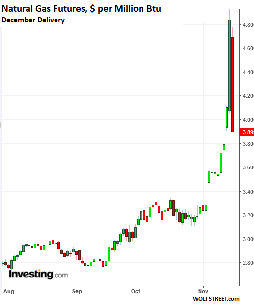
The spike yesterday was driven by “a sharp cold revision in the winter weather outlook,” according to a commodities strategist at Morgan Stanley, cited by Bloomberg. “We see modest downside from here assuming current weather forecasts, but a very wide range of potential short-term prices,” he said.

The weather outlook hasn’t really changed overnight, but instead of a “modest downside” move, natural gas performed a historic plunge today.

Speculative fever goes both ways. Today was impacted more than anything by the hangover from yesterday’s spike that completed a 45% run-up since November 2. Time to cash out.

And then there was the Weekly Natural Gas Storage Report, released this morning by the EIA. It was a cold shower, after the drunken party yesterday.

Turns out, thanks to surging production, 39 billion cubic feet were addedduring the latest reporting week to underground storage facilities across the US. Over the past five years on average – with the colder season having already started at this week in November — natural gas levels in storage would drop by 15.6 billion cubic feet during that week.

…click on the above link to read the rest of the article…

Why Natural Gas Prices Will Rise This Summer

Why Natural Gas Prices Will Rise This Summer

shale gas

Record production of natural gas is snuffing out any price rally that might have occurred from the bout of cold weather this winter.

The gas market saw a jolt at the end of December and in early January due to extremely cold temperatures across much of the U.S. This winter was about 13 percent colder than last year, which pushed up residential and commercial gas demand by 3.5 billion cubic feet per day (Bcf/d), according to Barclays.

At the same time, demand continues to grind higher on a structural basis, with more LNG exports leaving U.S. shores and more utilities burning gas for electricity. That led to a sharp drawdown in gas inventories, pushing them 16 percent below the five-year average in the first quarter.

Nevertheless, the price impact was muted. In the past, sever cold snaps have led to sharp price spikes. While that happened in regional spot markets, the price increases were very short-term and nothing like the price increases during the 2014 Polar Vortex. After the cold subsided, Henry Hub spot prices fell back below $3/MMBtu.

Gas traders are so sanguine because the U.S. is producing more natural gas than ever. And 2018 is shaping up to be a record year for new gas output. A mild streak during February eased some pressure on inventories as well.

As a result, the U.S. will likely see “heavy” gas injections during the second quarter, according to Barclays. The bank expects gas inventories to rise at a pace that is 1 Bcf/d higher than last year.

…click on the above link to read the rest of the article…

“Sudden Stratospheric Warming Event” Fractures The Polar Vortex In Two

This split of the polar vortex will shift the upper atmospheric pattern such that the coldest airmass is located in western North America as well as over parts of Europe. This will allow for a ridge of high pressure to amplify in the eastern US, bringing unseasonably warm conditions next week,” said Ed Vallee, Long-Range Meteorologist and President of Vallee Wx Consulting.

The Weather Channel describes the atmosphetic impact for the Northern Hemisphere, as this unique weather event splits the polar vortex into two smaller vortices: one over western Canada and another over Europe.

  •  A split of the polar vortex occurred this week due to warming in the stratosphere
  • This is likely to result in cold temperatures in Europe
  • Although a disruption of the polar vortex is sometimes associated with cold weather in the eastern U.S., that is not always guaranteed

Further, from the Weather Channel:

“Across the Arctic, where the polar vortex typically stays locked, the stratosphere has warmed. This typically kicks into motion a polar vortex disruption like we are seeing. The stratosphere is a layer of the upper atmosphere above which most of our weather occurs – known as the troposphere – and where most of the polar vortex resides.” (Shown Below: The polar vortex has split into smaller vortices, one over Europe, and the other over northwestern North America.)

The one vortex over Western Europe and much of Eurasia will send the region into a dangerous deep freeze for the second half of February into early March. A disruption of the polar vortex has sent March 18 U.K. natural gas contracts soaring on the session, advancing +3.6% to 51.540.

…click on the above link to read the rest of the article…

Northeast Facing Record-Low Temperatures As Polar Vortex Returns

Northeast Facing Record-Low Temperatures As Polar Vortex Returns

The return of the dreaded polar vortex is battering much of the eastern US this week, sending temperatures well into freezing territory and close to record lows – a phenomenon that could persist for much of the week leading up to Thanksgiving.

According to the New York Post, record-low temperatures are forecast for Friday and Saturday, with nighttime and early-morning mercury dipping into the 20s.

The temperature dropped into the 20s in some places in the northeast last night, and could sink as low as 21 degrees fahrenheit on Saturday, according to AccuWeather forecasts.

The record low for November 10 was 27 degrees in 1914. The high Saturday will be 37 to 43 degrees – up from the predawn low of about 24 degrees. The record low for November 11 was 29 degrees, set in 1933.

The forecast calls for 50 degrees on Monday, setting off eight straight days with high temps of at least 50, AccuWeather said.

The forecasting service added that signs are pointing toward a shift of the polar vortex that may cause snow, rain and other hazardous weather conditions like icy roads in some parts of the Northeast.

Right now, a cold snap is bringing an abrupt November reality check to most of the eastern US that will persist for the rest of the Veterans’ Day weekend. As Accuweather explains, the weather pattern will become even more interesting later in the week because it will feature a meteorological phenomenon called “the Greenland block”.

This pattern consists of relatively high pressure wind pattern near greenland that forces the polar jet stream to move sharply south toward the eastern US.

…click on the above link to read the rest of the article…

What is the Polar Vortex? How does it work?

What is the Polar Vortex? How does it work?

Monday, March 28, 2016, 1:48 PM – It is safe to say 2014 was the year ‘polar vortex’ muscled its way into the public lexicon for talking about the weather, and for good reason.

The winter of 2013/2014 was bitterly cold across much of North America. In fact, according to Environment Canada it was the coldest Canadian winter in 18 years, and third coldest in 35 years. Nationally, the five months from November to March were Canada’s coldest since record-keeping began in 1948.

Needless to say, cold records were handily broken in many communities, and many cities issued vastly more cold weather alerts than in the previous winters.

Economically  the cold, along with strong snowfalls and an ice storm, played havoc with power grids and infrastructure, and plants’ “winterkill” rates were higher than normal.

So was the polar vortex responsible? Oh yes. But the phenomenon wasn’t new by any means.

What is the Polar Vortex?

Simply, the Polar Vortex is a large area of cold air and low pressure that sprawls across Earth’s poles. The scary-sounding “vortex” monicker comes from the fact that it’s cyclonic: It rotates (counter-clockwise in the Northern Hemisphere) in a flow of air that keeps cooler air near the poles.

Image: NOAA

It’s also fairly high up in the lower/middle stratosphere, but its effects stretch down into the upper part of the troposphere, the first layer of Earth’s atmosphere where our planet’s weather takes place.

The polar vortex is really dependent on large-scale temperature variations in Earth’s atmosphere between the poles and the equator as the year progresses. As such, the polar vortex is confined to polar latitudes in summertime, but “dips” in the winter as the northern hemisphere’s average temperatures drop, bringing colder air southward.

…click on the above link to read the rest of the article…

East Coast Celebrates Christmas With Warmest Weather On Record

East Coast Celebrates Christmas With Warmest Weather On Record

It was just 10 months ago that Boston smashed its all time snowfall record, and the US was blanketed in freezing weather from west to east as the Polar Vortex unleashed cold air for the second year in a row. It was so cold, the GDP report for the winter period had to be double-seasonally adjusted as the sharp economic slowdown, which was blamed on the “harsh weather”, simply did not make sense otherwise.

Fast forward to today when according to AccuWeather, Christmas felt more like Memorial Day across much of the eastern United States as temperatures rose between 20 and 35 degrees above average and 5-15 degrees above previous record highs.

While unlikely that it was the hottest Christmas ever – temperature recordings only go so far – records were broken all along the Eastern Seaboard, from the Southeast to New England with some areas breaking their previous record high by more than 10 degrees F. Some records were broken from the 1800s.

The highs that occurred on Thursday are more typical of late spring and early summer.

More from AccuWeather:

“One of the most impressive records on Christmas Eve occurred in Burlington, Vermont, when the city set their all-time December high temperature,” AccuWeather Meteorologist Brian Lada said.

Burlington rose to 68 F on Christmas Eve, 17 degrees higher than the previous record of 51 F set in 1957. The all-time warmest day prior to Thursday in Burlington was on Dec. 7, 1998 and Dec. 5, 1941 when it reached 67 F.

As a result of the warm weather, the entire Northeast was left without a white Christmas. The only location which saw at least an inch of snow accumulation on the ground on Christmas was across northern Maine. “Records also fell all along the Interstate 95 corridor from Boston through Washington, D.C.,” Lada said.

…click on the above link to read the rest of the article…


Olduvai IV: Courage
Click on image to read excerpts

Olduvai II: Exodus
Click on image to purchase

Click on image to purchase @ FriesenPress