Home » Posts tagged 'northeast north america'

Tag Archives: northeast north america

Olduvai
Click on image to purchase

Olduvai III: Catacylsm
Click on image to purchase

Post categories

Post Archives by Category

White Christmas? Meteorologists Warn Of Potential “Blizzard Over East Coast”

White Christmas? Meteorologists Warn Of Potential “Blizzard Over East Coast”

Long-range weather models forecast the increasing possibility of a white Christmas for parts of the Northeast.

“Some of the models are depicting a weather pattern taking shape that could result in very cold air pouring into the central and eastern United States next week — which could set the stage for a potential winter storm along the East Coast heading into Christmas weekend,” media outlet NJ.Com wrote.

NY NJ PA Weather’s meteorologist Steven DiMartino said there’s still uncertainty around forecasts but says signs are emerging of a potential East Coast winter storm next week.

DiMartino said atmospheric patterns and a few weather models show what appears to be a developing storm that has the “potential to be pretty impressive.”

“However, before anyone starts putting out snow maps or anything else that you might see on social media, understand there are a lot of moving parts in this storm,” he noted.

“You have a disturbance in the subtropical jet stream, interaction with the Gulf stream — which is a very warm body of water off the East Coast — and an impressive Arctic air mass driving towards all of that rising air,” DiMartino continued.

“When you have all these features come together, usually a big storm evolves … but as far as the details are concerned, I caution you not to jump on every model guidance that shows up, because a lot can change over the next couple of days,” he added.

DiMartino explained more in the YouTube video.

DiMartino said the storm’s exact timing, track, and impacts are still unknown. Such forecasts will be made available in the coming days.

Another meteorologist by the name of Joe Bastardi, who runs WeatherBELL Analytics LLC, tweeted:

…click on the above link to read the rest…

East Coast retail diesel prices moving significantly higher than overall US hikes

East Coast retail diesel prices moving significantly higher than overall US hikes

Extremely tight inventories are seen as the driving factor blowing out spreads with benchmark Gulf Coast market

 East Coast diesel prices are racing ahead of the rest of the country. Photo: Jim Allen/FreightWaves

East Coast retail diesel prices are soaring relative to the rest of the country, propelled by inventories in the region that are almost half of what they normally should be at this time of year.

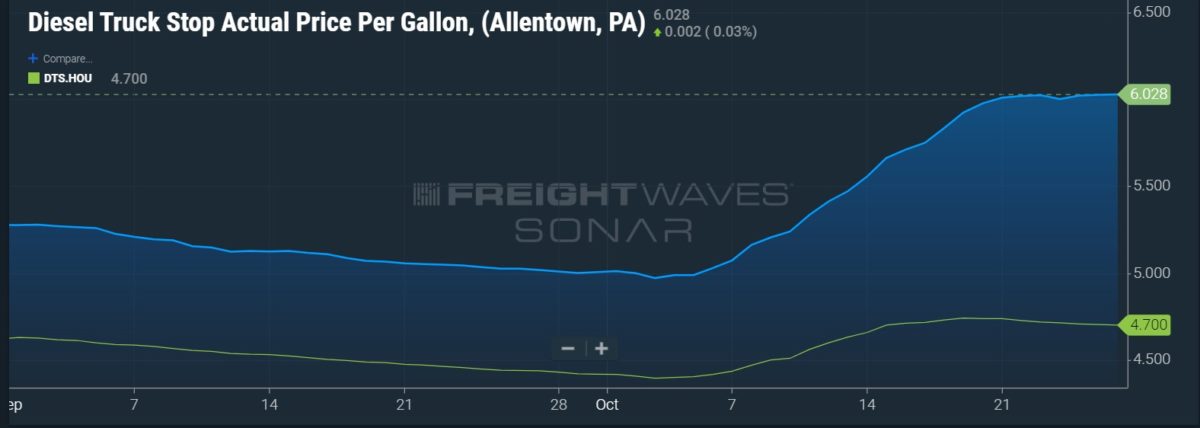
Retail prices recorded in the DTS data series in SONAR tell the story of how much diesel has surged. On Sept. 16, retail diesel in Allentown, Pennsylvania, a major logistics center, was $5.116 a gallon, while the Houston price was $4.513 a gallon, a spread of just over 60 cents. On Oct. 15, Allentown was $5.663 a gallon while Houston was $4.70, a 96.3 cent gap. By Thursday, Allentown was at $6.028 a gallon and Houston was $4.70 a gallon, a spread of $1.328 a gallon.

The green line represents the DTS.HOU price for average retail diesel prices in Houston. The blue shaded area is the DTS data for Allentown.

The East Coast price blowout has been propelled largely by the tight inventory situation in what is known as PADD 1, the Department of Energy’s designation for that region.

Weekly statistical data reported by the EIA this week had PADD 1 inventories of ultra low sulfur diesel at 21.3 million barrels for the week ended Oct. 21, a more than 7% decline in just one week. But more striking was the fact that those inventories are 56.5% of the five-year average for the corresponding October weeks, excluding the pandemic-influenced data from 2020.

By contrast, national inventories for all distillates, which are not broken down by specific grades, are running about 80-81% of the five-year average, and that is considered extremely tight by analysts.

…click on the above link to read the rest…

100 Million Americans In Path Of Dangerous Winter Storm

100 Million Americans In Path Of Dangerous Winter Storm

A massive winter storm could impact upwards of 100 million people across the Southeast, Mid-Atlantic, and Northeast during the latter part of the Martin Luther King Jr. holiday weekend.

National Weather Service (NWS) issued winter storm warnings for 19 states, with some areas over the Appalachians could experience a snowfall rate of 1-3 inches per hour.

“A major Winter Storm will impact the eastern U.S. on Sunday into Monday. The highest snowfall totals are expected along the spine of the Appalachians as well as across the lower Great Lakes. The most significant icing is expected over the Carolinas this morning. Significant impacts to travel across these regions are expected,” NWS warned. 

Winter storm warnings have been issued for these states: New York, Ohio, Vermont, Virginia, Kentucky, Maine, Massachusetts, Arkansas, New Jersey, Pennsylvania, Georgia, North Carolina, South Carolina, Tennessee, West Virginia, Maryland, Louisiana, Alabama, Mississippi and the District of Columbia.

AccuWeather expects 6-12 inches of snow along the Appalachians and even into Ohio and western New York. There’s a strong likelihood that snow accumulations of 3 feet could be seen at higher elevations in the Appalachians, Adirondacks, the Green and White mountains, and parts of southwestern New York near Lake Ontario.

Pittsburgh, Johnstown and Scranton, Pennsylvania; Buffalo, Binghamton, Albany and Syracuse, New York; Morgantown, West Virginia; Cleveland; Pittsfield, Massachusetts; Burlington, Vermont; and Caribou, Maine; all face accumulating snow through Monday. As for metro areas along the I-95 corridor, expect 1-3 inches of snow, with a mixture of ice and rain. The heaviest snowfalls will be in the interior Northeast.

On Friday, weather models forecasted the heaviest snowfall would be west of the I-95 corridor — so far, they’re right.

2,200 Flights Canceled As Winter Storm Pounds Northeast

2,200 Flights Canceled As Winter Storm Pounds Northeast

Friday brought more bad news for airlines and their customers with 2,200 flight cancellations as a winter storm blanketed mid-Atlantic and Northeast states and staffing shortages due to COVID-19 infections.  Southwest Airlines, United Airlines, American Airlines, JetBlue, and regional carrier SkyWest Airlines are the hardest hit this morning, according to data provided by FlightAware.

FlightAware showed most of the canceled flights originated at Northeast airports, such as LaGuardia, Boston Logan International, John F. Kennedy International, and Newark Liberty International.

The high number of cancellations is a multiprong issue. First, crew shortages showed no signs of easing two weeks after beginning on Christmas Eve due to Omicron. Second, a winter storm dumped accumulating snow over the Tri-State region.

Flight delays and cancellations are likely to worsen throughout the day and spill over into Saturday.

Isaias Aftermath: 2 Million Still Without Power Across Northeast; At Least 12 Tornados Confirmed

Isaias Aftermath: 2 Million Still Without Power Across Northeast; At Least 12 Tornados Confirmed

Tropical Storm Isaias is long gone, but there’s widespread damage along the East Coast and more than 2 million homes in the Northeast without power. 

According to PowerOutage.US, 2.2 million of the 6.4 million affected electric customers remain without power in the aftermath of Isaias. 

PowerOutage.US said utility workers from across the nation have responded to East Coast states to aid in the recovery effort to restore power. So far, 65% of affected customers have seen their lights turned back on. 

From the Carolinas to the Delmarva Peninsula to New Jersey to New York City, Isaias unleashed tropical storm conditions earlier this week. For those who are curious, here’s the full track map of the storm:

At one point, nearly 100 tornado warnings were issued across ten states as the storm raced up the East Coast. 

Isaias spawned at least a dozen confirmed twisters. 

Here’s some video of the damage:

The aftermath of a tornado in Doylestown, Pennsylvania. 

Buildings ripped apart in Dover, Deleware. 

Tornado touched down in Cape May, New Jersey. 

Homes damaged in Maryland.

“Damage from isaias in Courtland va  I worked down there today it was unreal first real tornado damage I’ve seen first hand,” said one Twitter user.

What Americans saw on the news this week… 

Stressful times.

Major Winter Storm Threatens Millions In Northeast This Weekend

Major Winter Storm Threatens Millions In Northeast This Weekend

A powerful winter storm is expected to dump snow and ice across the Midwest and Northeast this weekend. 

Early indications suggest wintry precipitation is possibly Saturday as the winter storm transitions from Midwest states to the Mid-Atlantic and Northeast, while heavy snow could fall in some areas. 

We noted on Monday how the Global Forecast System (GFS) data shows Old Man Winter will return to the Northeast on Friday with average temperatures from Washington, D.C., to Boston around 25 to 34 degrees. This could make conditions ripe for a snowstorm over the weekend. 

The National Weather Service (NWS) is projecting that snow and ice could be seen on early Saturday for Mid-Atlantic states, with mixed precipitation in the afternoon. The further north, the higher the probability of significant snowfall. 

“Although confidence continues to increase on the potential for a winter storm for parts of our area (above average confidence for this time range, in fact), it is still too early to get into specifics on timing and amounts of different precipitation types given … this is still 4 to 5 days away,” NWS said Tuesday. 

Henry Margusity, a meteorologist for Weather Madness, provides several weather charts that indicate the storm could quickly impact tens of millions of folks in the Mid-Atlantic and Northeast this weekend. 

Margusity provides another chart showing the winter precipitation could start early Saturday morning in the Baltimore–Washington Metropolitan Area and move up the Interstate-95 corridor in the Northeast through Saturday afternoon into the evening. 

“As you can see on the image above, this will be a widespread snow and ice event covering many states from the Plains to the Northeast. The snow will be in general 1-6 inches but locally 8-9 inch amounts will occur. Ice is probably marginal in this storm as the snow will change to just rain in the changeover locations shown in pink on the map,” Margusity said. 

…click on the above link to read the rest of the article…

Powerful Winter Storm To Dump Snow And Ice From Northern Plains and Upper Midwest to Northeast

Powerful Winter Storm To Dump Snow And Ice From Northern Plains and Upper Midwest to Northeast

Winter Storm Gage is producing snow, ice, and strong winds from the Northern Plains and upper Midwest Sunday will move into the Northeast early next week and unleash a wintery mess that could cause severe travel headaches ahead of New Years, reported The Weather Channel

The storm is expected to traverse across a broad area from Nebraska to Dakotas to northern and western Minnesota. Snow and high winds could produce blizzard conditions in these areas throughout Sunday. Some regions could see as much as 12 inches by Monday morning.

The National Weather Service (NWS) published winter storm warnings, watches, and advisories for parts of the Central Plains into the northern Great Lakes, eastern upstate New York and parts of New England.

NWS warned, “the same winter storm that is impacting areas of the Plains and Upper Midwest will be heading east next week and is expected to bring locally significant snow and ice across portions of the Northeast ahead of the New Years holiday.” 

…click on the above link to read the rest of the article…

Winter Storm: Northeast Braces For Next Round Of Harsh Weather This Weekend

Winter Storm: Northeast Braces For Next Round Of Harsh Weather This Weekend

Just when Zerohedge readers thought it was time for spring, old man winter has a few more tricks up his sleeve. New weather models show several storms will affect the Northeast over the weekend.

The storm system that brought severe weather from California to the Midwest is beginning to shift and could threaten Mid-Alantic and Northeast cities with snow, ice, and rain by this weekend.

Winter Storm Ryan will begin along the West Coast by late Friday, then move across  Rockies, Plains, Ohio Valley and Northeast through the weekend.

Winter storm watches have been published for California’s Sierra, Central Midwest, Mid-Atlantic, and Northeast, where the weather is expected to deteriorate in the next 24 to 48 hours.

The storm is expected to impact the Northeast late Sunday into early Monday.

“The exact track of that storm and magnitude of the lingering cold air in its path will determine the extent and intensity of snow, ice and rain in the Eastern states from Sunday to early Monday,” according to AccuWeather Meteorologist Courtney Travis.

Here are the scenarios at play

If Winter Storm Ryan takes a northeastward route toward the central Appalachians and the mid-Atlantic coast as Travis believes (scenario 1), 4 to 8 inches of snow may fall from central Plains to the northern part of the Ohio Valley, the eastern Great Lakes, the Allegheny and Pocono mountains in Pennsylvania and northern New England.

This shift eastward would allow the bulk of the snow to fall in Washington, D.C., Baltimore, Philadelphia, New York City and perhaps Boston. Such a path could result in significant travel disruptions Monday.

A new wave of Arctic air expected 

Despite Winter Storm Ryan’s track, a significant blast of Arctic air is inbound for Northeast and Midwest.

High winds will follow the leading edge of the Arctic air. 

Gusts between 40 and 55 mph are expected over the Upper Midwest and 30 and 45 mph in the Northeast.

AccuWeather said the blend of wind and falling temperatures would send RealFeel® Temperatures well below zero over the Upper Midwest, Mid-Alantic and Northeast.

And You Thought Bitcoin Was Volatile…

And You Thought Bitcoin Was Volatile…

If you are one of those people living in the Northeast who likes to keep their home temperature above freezing and waking up without frostbite, we have some bad news…

Another sudden bout of cold weather and LNG prices are soaring more than the seasonal norm.

Your heating bill may have just exploded over 300%…

Northeast Forecast To Get Big Winter Blast

Northeast Forecast To Get Big Winter Blast

Three days ago, we asked: Is A Major Winter Blast Coming To The East Coast This Christmas? Despite all the chatter from global warming alarmists this year, there is a chance, some in the Northeast could experience a white Christmas.

Ed Vallee, a private weather forecaster based in Connecticut, reports merging storms will spread snow, rain, and mixed conditions from the central Appalachians to New England. The system will start on Sunday night and continue into Monday. Snow totals are forecasted to bring 2-8″ for parts of the Northeast (shown below). 

Vallee discusses the risks associated with the storm, along with more details into the timing of this system.

AccuWeather Senior Meteorologist Brett Anderson, confirms Vallee’s forecast and said, there will be “enough snow to shovel and plow is likely from western and northern Pennsylvania and southern Ontario to Maine, New Brunswick, and Nova Scotia.”

Here are the highways that could be heavily impacted by the storm include Interstate 70, I-76, I-78, I-80, I-81, I-84, I-86, I-87, I-88, I-89, I-90, I-91, I-93, I-95, and I-390. AccuWeather’s team expects delays at airports in Pittsburgh, New York City, and Boston.

Also, the National Weather Service has issued a deluge of winter weather advisories and warnings for the Northeast (as of 12-24).

The National Oceanic and Atmospheric Administration (NOAA) provides an animated Gif depicting the trajectory of the system with the different types of precipitation probabilities.Accuweather sheds more color on the storm:

From just north and east of Philadelphia to New York City, Providence, Rhode Island, and New Bedford, Massachusetts, just enough snow may fall to cover the ground, just in time for a White Christmas.

Farther south and west from Atlantic City, New Jersey to Baltimore and Salisbury, Maryland, and Washington, D.C., little or no snow is likely. Little or no rain may fall as well due to a gap in the storm.


…click on the above link to read the rest of the article…

Northeast Facing Record-Low Temperatures As Polar Vortex Returns

Northeast Facing Record-Low Temperatures As Polar Vortex Returns

The return of the dreaded polar vortex is battering much of the eastern US this week, sending temperatures well into freezing territory and close to record lows – a phenomenon that could persist for much of the week leading up to Thanksgiving.

According to the New York Post, record-low temperatures are forecast for Friday and Saturday, with nighttime and early-morning mercury dipping into the 20s.

The temperature dropped into the 20s in some places in the northeast last night, and could sink as low as 21 degrees fahrenheit on Saturday, according to AccuWeather forecasts.

The record low for November 10 was 27 degrees in 1914. The high Saturday will be 37 to 43 degrees – up from the predawn low of about 24 degrees. The record low for November 11 was 29 degrees, set in 1933.

The forecast calls for 50 degrees on Monday, setting off eight straight days with high temps of at least 50, AccuWeather said.

The forecasting service added that signs are pointing toward a shift of the polar vortex that may cause snow, rain and other hazardous weather conditions like icy roads in some parts of the Northeast.

Right now, a cold snap is bringing an abrupt November reality check to most of the eastern US that will persist for the rest of the Veterans’ Day weekend. As Accuweather explains, the weather pattern will become even more interesting later in the week because it will feature a meteorological phenomenon called “the Greenland block”.

This pattern consists of relatively high pressure wind pattern near greenland that forces the polar jet stream to move sharply south toward the eastern US.

…click on the above link to read the rest of the article…

Olduvai IV: Courage
Click on image to read excerpts

Olduvai II: Exodus
Click on image to purchase

Click on image to purchase @ FriesenPress