…click on the above link to read the rest of the article…
Home » Posts tagged 'nhc'
Tag Archives: nhc


Hurricane Ian Strengthens To Powerful Category 4 As Florida Landfall Imminent
Hurricane Ian Strengthens To Powerful Category 4 As Florida Landfall Imminent
Hurricane Ian strengthened into a powerful Category 4 storm expected to make landfall on Florida’s southwest coast today and then traverse central Florida and emerge in the Atlantic by Thursday.
At 0500 ET, the National Hurricane Center said Ian sustained maximum winds of 140 mph and gusts up to 165 mph. The storm’s center was about 75 miles west-southwest of Naples and 105 miles south-southwest of Punta Gorda, moving north-northeast at 10 mph.
“Ian is forecast to approach the west coast of Florida as an extremely dangerous major hurricane, weakening is expected after landfall.
“On the forecast track, the center of Ian is expected to approach the west coast of Florida within the hurricane warning area this morning, and move onshore later today. The center of Ian is forecast to move over central Florida tonight and Thursday morning and emerge over the western Atlantic by late Thursday,” NHC senior hurricane specialist Daniel Brown told Orlando Sentinel.
Ian’s path has shifted south of Tampa Bay, and landfall is now expected between Fort Myers and Sarasota on Wednesday morning or early afternoon before moving across the central part of the state.

NHC warned a “life-threatening storm surge is expected along the Florida west coast and the Lower Florida Keys,” with “devastating wind damage” expected near Ian’s center.
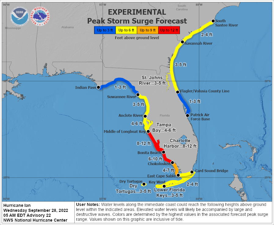
“Catastrophic flooding is expected across portions of central Florida with considerable flooding in southern Florida, northern Florida, southeastern Georgia and coastal South Carolina,” the weather agency continued.
“It’s going to be historic,” National Weather Service Melbourne meteorologist Kole Fehling in Melbourne, referring to the storm’s landfall impacts.
Fehling said Central Florida could be swamped with 15 to 20 inches of rainfall, with some areas receiving upwards of 24 inches.
…click on the above link to read the rest of the article…
‘Extremely Dangerous’ Hurricane Willa Now Category 5 Off Mexico’s Pacific Coast
Hurricane Willa has rapidly intensified into an “extremely dangerous” category five storm in the eastern Pacific, with computer models early Monday forecasting landfall on Mexico’s western coast between Mazatlan and Perto Vallarta in the next several days.
According to The Washington Post, state governments of Sinaloa and Nayarit began preparing emergency shelters ahead of the life-threatening storm.
The U.S. National Hurricane Center (NHC) warned early Monday morning that Willa could “produce life-threatening storm surge, wind, and rainfall over portions of southwestern and west-central Mexico beginning on Tuesday.”
Ed Vallee, a meteorologist at Vallee Wx Consulting, said Willa is a powerful category four hurricane, with winds similar to Hurricane Michael when it made landfall on the Florida panhandle Oct. 10. He warned the system will slam into southwestern and west-central Mexico region early this week, then could cause flooding conditions in Texas.
“Hurricane Willa is quickly approaching the southwestern Mexican coast this week, complete with sustained winds at 155 mph and gusts up to 190 mph. Over the last 48 hours, this system has encountered very favorable conditions for rapid intensification including low wind shear, very warm water temperatures and favorable upper atmospheric conditions. From Saturday morning to Monday morning, the system strengthened from 40 mph to 155 mph thanks to these favorable conditions. This system will bring life-threatening storm surge, wind, and rain to southwestern and west-central Mexico this week, and will eventually bring additional flooding rains to Texas as well,” said Vallee (Oct. 22 10 am est.)
Hurricane warnings have been posted for Mexico’s western coast between San Blas and Mazatlan, including the Islas Marias, a nature reserve and federal prison.

By early Monday, Willa had maximum sustained winds of 160 mph and was centered about 200 miles south-southwest of the Islas Marias and 155 miles south-southwest of Cabo Corrientes moving north at seven mph.
…click on the above link to read the rest of the article…
“Even Rescuers Can’t Stay”: Deadly Rain, Storm Surges Expected Even As Florence Weakens To Cat 2
With roughly 24 hours remaining until Hurricane Florence makes landfall in southeastern North Carolina, the storm has reportedly weakened to a Category 2 Hurricane. But meteorologists warn that this isn’t any reason for comfort: Because while the storm’s winds have slowed (from around 140 mph to a maximum of 125 mph), the potential for devastation from what’s expected to be one of the most extreme storms in American history remains acute.
And while the storm is no longer considered a “major” hurricane, CNN reports that its reach has expanded. And with the first wind bands set to batter the state beginning later Thursday, the Associated Press warned.
Despite the downgrade, officials warned that the storm will still have a devastating impact.
“Do you want to get hit with a train or do you want to get hit with a cement truck?” said Jeff Byard, an administrator with the Federal Emergency Management Agency.
Analysts are projecting as much as $30 billion in losses due to the storm. In what looks like a best case scenario, Florence eventually could strike as merely a Category 1 hurricane with winds less than 100 mph, but that’s still enough to cause at least $1 billion in damage, Weather Underground meteorology director Jeff Masters said.
According to the NHC, The storm is expected to unleash extreme storm surges, historic flooding, and damaging winds beginning later Thursday, with the southeastern portion of North Carolina set to bear the brunt of Florence’s wrath. Rainfall could range between 20 inches to a staggering 40 inches. Between the rains and the storm surge, the flooding could be “catastrophic,” the Washington Post warned. As the storm moves inland on Friday, a pocket of tropical-storm-force winds nearly 400 miles wide will engulfing much of southern North Carolina and nearly all of South Carolina.
…click on the above link to read the rest of the article…
State Of Emergency Declared Across Southeastern US As Hurricane Nate Looms
State Of Emergency Declared Across Southeastern US As Hurricane Nate Looms
Update (1 pm ET): With Nate expected to strengthen into a category 2 storm by the time it makes landfall in southeastern Louisiana late Saturday, the NHC has expanded its storm warnings to include the part of the Florida panhandle east of the Okaloosa/Walton County Line to Indian Pass Florida, which is now under a tropical storm warning. Meanwhile, mandatory evacuations are set to begin in Port Fourchon, Louisiana at 12pm local time Saturday for remaining staff at the port, according to storm update by the Greater Lafourche Port Commission. This follows mandatory evacuation ordered by Lafourche Parish, La., President Jimmy Cantrelle for areas below floodgates in Golden Meadow, La. In addition, the US Coast Guard has suspended marine traffic activity as of 8 am local time for sector Mobile, which includes the ports of Gulfport and Pascagoula in Mississippi, Mobile, Ala., and Pensacola, Fla., in preparation for Hurricane Nate, according to an agency bulletin.
Staff at offshore oil rigs in the Gulf were ordered to evacuate, leaving nearly three-quarters of US Gulf of Mexico oil production was offline ahead of the storm. American Midstream Partners LP’s Destin gas pipeline and Enbridge Inc.’s Nautilus and Manta Ray lines are evacuating staff from Gulf platforms.

Thanks to Harvey, and now Nate, natural gas production in the Gulf of Mexico has plunged to the lowest level in three years. Gulf gas output may drop as much as 1.4 billion cubic feet a day, while 1.1 million barrels a day of offshore oil production and 3 million barrels of refining capacity are at risk, according to Shunondo Basu, an analyst at Bloomberg New Energy Finance.
…click on the above link to read the rest of the article…