Home » Posts tagged 'hurricane'

Tag Archives: hurricane

Olduvai
Click on image to purchase

Olduvai III: Catacylsm
Click on image to purchase

Post categories

Post Archives by Category

Cat 1 Hurricane Nicholas Makes Landfall On Texas Coast, Multiple Nuclear Power Plants In Path

Cat 1 Hurricane Nicholas Makes Landfall On Texas Coast, Multiple Nuclear Power Plants In Path

Hurricane Nicholas made landfall early Tuesday morning on the Matagorda Peninsula just south of Houston, Texas. Nicholas hit the area as a Category 1 but has since been downgraded to a tropical storm with maximum sustained winds of 70 mph. Oil refiners, chemical makers, grain exporters, and even multiple nuclear power plants are in its path.

Ahead of Nicholas’ arrival, two major oil export terminals either suspended or restricted vessel traffic. Port authorities in Corpus Christi halted inbound sailing; Ports in Houston and other surrounding areas restricted vessel traffic. Preparations for the storm included oil companies evacuating offshore oil/gas platforms and hunkering down land-based operations.

What’s on our radar this morning is the storm passing over the nuclear power station southwest of Bay City, Texas, about 90 miles southwest of Houston. The 12,200-acre site is home to South Texas Project Electric Generating Station. The storm is forecasted to arrive in oil and gas heavy Houston around 1800 local time.

At the moment, about 340,000 customers are without power in Southeast Texas.

Storm impacts and energy outages could be problematic for COVID hotspots.

Nicholas emerged on our radar last Friday as a tropical wave over Honduras, the western Caribbean Sea, and has since organized and strengthened into a hurricane and now downgraded to a tropical storm.

The National Hurricane Center (NHC) expects storm surges of 2 to 5 feet and up to 18 inches of rain in some areas over southeast Texas. Some of these areas are crammed with industrial facilities, and even coastal neighborhoods could be prone to flooding. One area to watch for flooding is Houston:

…click on the above link to read the rest of the article…

Hurricane Ida Exposes Grid Weaknesses As 2,000 Miles of High-Voltage Lines Damaged 

Hurricane Ida Exposes Grid Weaknesses As 2,000 Miles of High-Voltage Lines Damaged 

More than a million customers across Louisiana are without power on Tuesday morning. Some reports indicate it could take weeks for the lights to come back on as thousands of miles of transmission lines were damaged after Hurricane Ida rolled through on Sunday.

The Category 4 hurricane raises fresh questions about how well New Orleans and other coastal areas across Lousiana are prepared for natural disasters. As of 0630 ET, PowerOutage.US reports a little more than one million customers are without power across the state’s coastal plain.

Energy provider Entergy Corp has been surveying the damage since Monday and has found 207 transmission lines spanning more than 2,000 miles have been knocked out by the storm, according to WSJ.

Rod West, Entergy’s group president of utility operations, said drones, helicopters, and land-based vehicles are surveying the damage and estimate it could take at least three weeks to restore power.

“The hard part is that the geography is a rather wide swath,” West said. “That three weeks is not going to apply to everybody the same way.” He added some transmission towers need to be replaced entirely due to “significant wind” damage. 

West said the damage to the transmission system is more severe than Hurricane Katrina because Ida made landfall at 150 mph.

Besides transmission lines, some of Entergy’s powerplants have sustained damage. West said the damage at some plants would not hinder energy production. One of their nuclear power plants 25 miles west of New Orleans on the Mississippi River was shuttered ahead of the storm.

West said they’d rebuilt their transmission system over the years to withstand speeds of 150 miles an hour. Still, it appears some of those high-voltage cables that carry electricity from power plants to substations that connect to lower-voltage distribution lines, were no match for Ida.

…click on the above link to read the rest of the article…

“Extremely Dangerous” – Hurricane Ida Almost Category 5 Strength As It Nears Louisiana

“Extremely Dangerous” – Hurricane Ida Almost Category 5 Strength As It Nears Louisiana

Hurricane Ida has rapidly strengthened into a major hurricane with maximum sustained winds of 150 MPH, just seven mph shy of a Category 5. The storm is set to strike Louisiana later this afternoon/evening, and on the same day, 16 years ago, Hurricane Katrina struck the area.

As of 0600 ET, National Oceanic and Atmospheric Administration (NOAA) plane flew into the storm and found Ida is an “extremely dangerous Category 4 hurricane about to make landfall in southeastern Louisiana later today.”

Reports from an NOAA Hurricane Hunter aircraft indicate that maximum sustained winds have increased to near 150 mph (240 km/h) with higher gusts. The latest minimum central pressure estimated from reconnaissance aircraft data is 935 mb (27.61 in).

An elevated NOAA C-MAN station at Pilot’s Station East near Southwest Pass, Louisiana, recently reported a sustained wind of 82 mph (131 km/h) and a gust to 107 mph (172 km/h). Another NOAA elevated C-MAN station at Southwest Pass recently reported a sustained wind of 77 mph (124 km/h) and a wind gust of 93 mph (150 km/h).

Ida is currently over the Gulf of Mexico where it could strengthen even more before making landfall around 1800 ET.

A Hurricane Warning has been posted for Intracoastal City, Louisiana, to Pearl River, Mississippi.

Storm surges could be significant across Louisiana and Mississippi. For instance, a 10-foot to 15-foot storm surge is forecasted from Morgan City, Louisiana, to Ocean Springs, Mississippi. A storm surge of 5-8 feet is possible for Lake Pontchartrain.

…click on the above link to read the rest of the article…

“Busy In The Tropics” – Gonzalo To Become A Hurricane; Tropical Depression 8 Could Soak Texas

“Busy In The Tropics” – Gonzalo To Become A Hurricane; Tropical Depression 8 Could Soak Texas

Update (July 23)(5:15ET)): The National Hurricane Center (NHC) tweeted early Thursday morning that Tropical Storm Gonzalo is expected to “strengthen again” and “become a hurricane later today.” 

NHC said Barbados had issued a hurricane watch. Gonzalo could strike the tiny island on Saturday.   

“Busy in the Tropics,” tweeted meteorologist Brian Shields, who posted a weather map showing not just Gonzalo is barreling towards the Caribbean but Tropical Depression 8 is approaching Texas. 

Here’s a more detailed map of Tropical Depression 8’s potential path towards Texas this weekend. 

*   *   *

Update (8:55ET): Tropical Depression Seven has formed into Tropical Storm Gonzalo on Wednesday morning. The system is expected to move toward the Caribbean by the end of the week. 

*   *   *

Tropical Depression Seven is traversing the Atlantic Ocean between Africa and the Lesser Antilles and has a 90% chance it could strengthen into Tropical Storm Gonzalo in the next 48 hours, according to Colorado State University meteorologist Philip Klotzbach.  

Klotzbach tweeted, “Tropical Depression 7 has formed in the central tropical Atlantic and is forecast to become a named storm” on Wednesday. 

He said the sea surface temperatures in the North Atlantic correlate with “active Atlantic hurricane seasons.” 

…click on the above link to read the rest of the article…

Floridians Brace For Dorian As Hurricane Weakens To Category 3

Floridians Brace For Dorian As Hurricane Weakens To Category 3

Hurricane Dorian has weakened from a Category 4 storm down to Category 3, now with winds of 120 miles per hour, but experts and officials say it’s too soon for Floridians to relax.

The storm stalled over the island of Grand Bahama for a day, staying in roughly the same position for 12 hours. Prime Minister Hubert Minnis described the storm as a “historic tragedy,” with five people confirmed to have died. Roughly 13,000 homes have been destroyed or seriously damaged.

Now, it’s setting its sights on the Eastern seaboard. There are already reports of flooding in Miami.

 …click on the above link to read the rest of the article…

Panic Spreads To Georgia, Carolinas As Trump Warns Category 4 Hurricane Dorian “Very Hard To Predict”

Panic Spreads To Georgia, Carolinas As Trump Warns Category 4 Hurricane Dorian “Very Hard To Predict”

We’re starting to suspect that hurricane forecasters aren’t much better at predicting the future movements of storms than market forecasters are at predicting the future movements of markets.

To wit, on Saturday, the National Hurricane Center shifted its forecasts for Hurricane Dorian, placing a large swath of the American Southeast in its path. This inspired South Carolina Gov. Henry McMaster to declare a state of emergency, and prompted President Trump to declare that storms like Dorian are “very hard to predict.”

South Carolina’s order will enable “all state agencies to coordinate resources and sets into effect the State Emergency Operations Plan,” McMaster said. He went on to urge all South Carolinians to “prepare now”.


Looking like our great South Carolina could get hit MUCH harder than first thought. Georgia and North Carolina also. It’s moving around and very hard to predict, except that it is one of the biggest and strongest (and really wide) that we have seen in decades. Be safe!


As of Saturday afternoon, Dorian was sporting an unusually wide ‘cone of uncertainty,’ which is making it especially difficult to track, according to the NYT.

According to the NHC, since Dorian has slowed down and could now turn northward just before making landfall in the Continental US, “it is too soon to determine when or where the highest surge and winds could occur.” As a result, “the risk of strong winds and dangerous storm surge is increasing along the coasts of Georgia, South Carolina and North Carolina during the middle of next week.”

 …click on the above link to read the rest of the article…

“Things Are Going To Get Worse” – Florida Gas Shortages Intensify As Dorian Becomes Category 3 Hurricane

“Things Are Going To Get Worse” – Florida Gas Shortages Intensify As Dorian Becomes Category 3 Hurricane

Hurricane Dorian strengthened to a Cat 3 storm Friday afternoon with 115 mph winds as Florida Gov. Ron DeSantis promised state troopers would escort trucks of fuel to areas along the east coast that could be directly in the storm’s path amid worsening fuel shortages, ABC Newsreported.

Following several seriously damaging hurricane seasons in recent years, stores and gas stations were already reporting outages of critical supplies like bottled water and gas on Thursdayand the situation only got worse on Friday, as even more gas stations reported running out of fuel.

Gasoline price-tracking app GasBuddy estimated that 31% of retail gas sellers in the Orlando-Daytona Beach-Melbourne area were dry as of Friday morning, according to Bloomberg.


.@FLHSMV FHP State Troopers will provide escorts to fuel trucks to ensure they reach critical areas more quickly. We are working closely with the fuel industry to ensure there is an adequate supply of fuel statewide as Hurricane #Dorian approaches.


Despite being the third-most-populous state in the country, Florida doesn’t have a single fuel pipeline. The nearest one is a Colonial line that delivers to Bainbridge, Georgia. From there, gas is loaded onto trucks and shipped to gas stations. The state also relies on tanker deliveries for fuel, which could create serious problems if the storm leaves the state’s ports shut for days, BBG reports.

Florida Petroleum Marketers Association executive director Ned Bowman said trucks were lined up at wholesale fuel terminals. Two tankers carrying refined petroleum products were heading to a port in the Everglades near Fort Lauderdale. Despite this, Bowman said the supply situation was still “pretty good.” 

 …click on the above link to read the rest of the article…

Florida Declares State Of Emergency As Hurricane Dorian Set To Ruin Labor Day Weekend

Florida Declares State Of Emergency As Hurricane Dorian Set To Ruin Labor Day Weekend

Just in time to spoil Labor Day weekend, Hurricane Dorian has barreled through the US Virgin Islands and Puerto Rico without causing much damage, and is now headed straight for the Florida coastline. After intensifying from a tropical storm into a hurricane late Wednesday, the storm continued to strengthen as it pulled closer to the Continental US.

The storm is expected to continue strengthening over the next few day, and is expected to make landfall on Florida’s Atlantic coast as a CAT 3 storm late Sunday or Monday.


Hurricane Dorian is strengthening and may hit the US as a Category 3. It’s forecast to grow into a major storm over Labor Day weekend before making landfall along the east coast of Florida. https://cnn.it/32f6wYq 

Track Dorian: https://cnn.it/2zqdugK 


In typical fashion, president Trump warned that Dorian will be “a very big storm, perhaps one of the biggest!” and urged people to follow state and federal instructions.


Hurricane Dorian looks like it will be hitting Florida late Sunday night. Be prepared and please follow State and Federal instructions, it will be a very big Hurricane, perhaps one of the biggest!


As of 5 am ET on Thursday, Dorian’s center was some 150 miles north-northwest of San Juan, as it headed northwest at 13 mph, according to the National Hurricane Center. Dorian’s sustained winds increased to 85 mph, with higher gusts recorded.

Heavy rain from the storm could cause “life threatening” flash floods in parts of the Bahamas on Thursday, and even along the southeastern US coast.

CBS News weather producer David Parkinson said that “with a new supermoon and the angle the storm is approaching from, widespread coastal flooding, including severe coastal flooding is likely. In addition, as the storm is coming in for landfall, it looks like it might lose some of the steering currents.”

 …click on the above link to read the rest of the article…

Which SHTF situation is most likely to actually happen?

Which SHTF situation is most likely to actually happen?

Image: Which SHTF situation is most likely to actually happen?

(Natural News) The prepping lifestyle can be overwhelming for most people but at its core, preppers prioritize readiness in all aspects of their lives. But amid all the talk about prepping skills, survival gear, and food supplies, how do you know which disaster event has the highest chance of occurring within your lifetime? (h/t to TheSurvivalistBlog.net)

How to prepare for possible SHTF events

For this article, an “SHTF” event is defined as “any event that upends your life” after it occurs, such as flooding in a major city. These events would be classified as major disasters or catastrophes, not personal emergencies.

On the extreme end of prepping are those who will do whatever it takes to get ready for apocalyptic events like EMP attacks or nuclear world war. However, more realistic preppers are concerned about events that may likely occur in their lifetimes, such as hurricanes or tornadoes.

No matter where you land on the prepping scale of SHTF-readiness, the important thing is to get ready for disasters that happen yearly worldwide.

Take note that the events detailed below are more or less likely to occur depending on your location. According to the U.N.’s Office for Disaster Risk Reduction (UNDRR), the single most likely natural disaster to occur anywhere in the world is flooding.

Flood preparedness

Rising water is “the most likely disaster to befall you anywhere in the developed world,” with about 30 percent of all disasters categorized as flooding. This coincides with data gathered by U.S.-based disaster response agencies and insurers.

Regardless of what causes flooding, it is a deadly and destructive event that occurs yearly. In most cases, a local major body of water will overrun its banks due to several days of heavy rain. However, other factors like dam failure, ice or snow melting, or tsunamis can also create severe flooding. 

 …click on the above link to read the rest of the article…

A Record 7 Named Storms Are Swirling Across The Globe – Has ‘The Day After Tomorrow’ Arrived?

A Record 7 Named Storms Are Swirling Across The Globe – Has ‘The Day After Tomorrow’ Arrived?

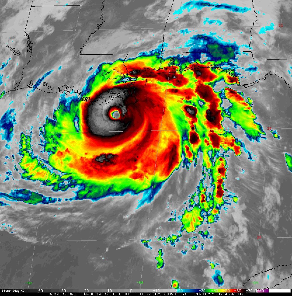
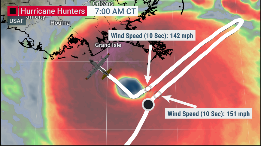
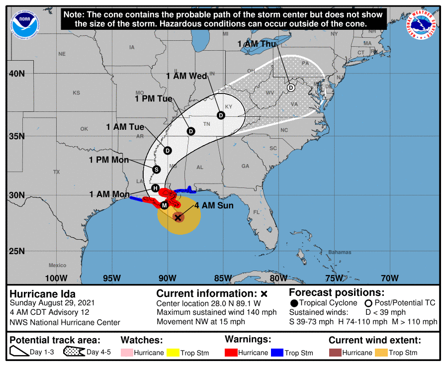
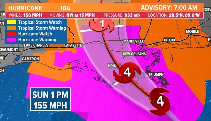
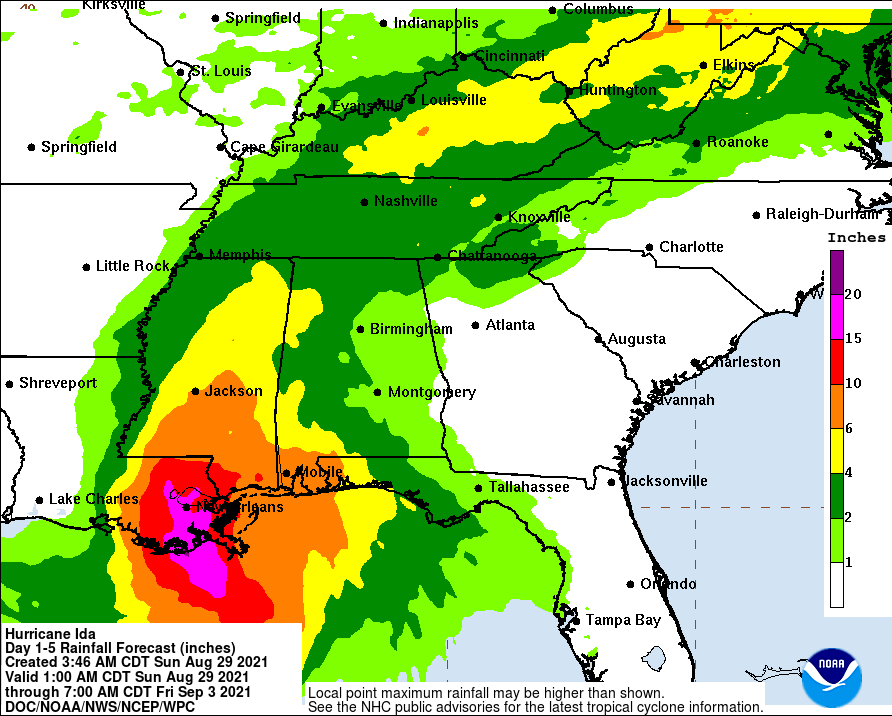
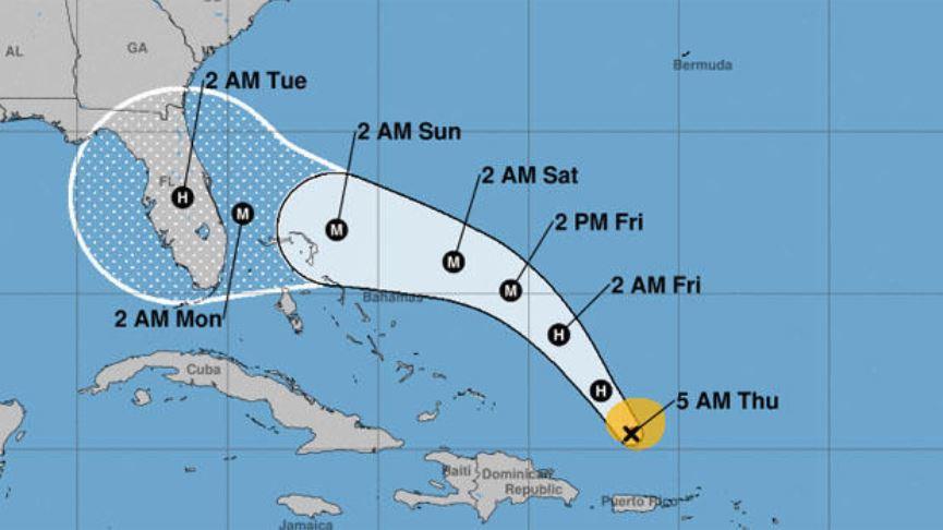
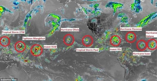
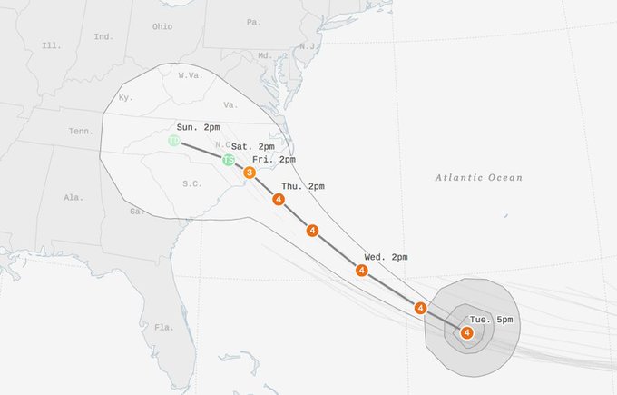
Is something extremely unusual happening to our planet?  At this moment, Hurricane Florence is just one of seven named storms that are currently circling the globe.  That matches the all-time record, and it looks like that record will be broken very shortly as a couple more storms continue to develop.  Back in 2004, a Hollywood blockbuster entitled “The Day After Tomorrow” depicted a world in which weather patterns had gone mad.  One of the most impressive scenes showed nearly the entire planet covered by hurricane-type storms all at once.  Of course things are not nearly as bad as in that film, but during this hurricane season we have definitely seen a very unusual number of hurricanes and typhoons develop.  As our planet continues to change, could this become “the new normal”?

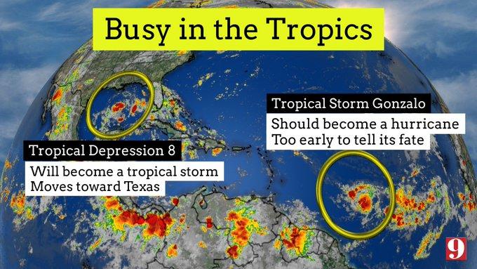
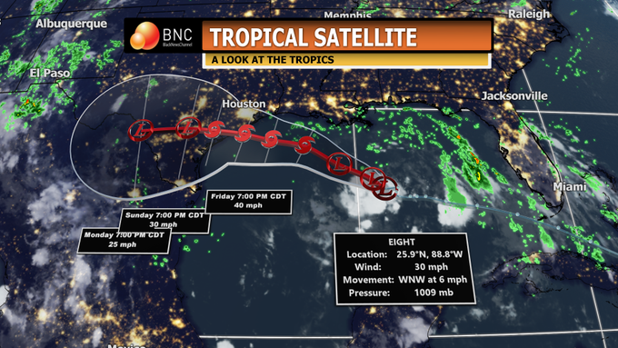
As I mentioned above there are currently seven named storms that are active, but an eighth is about to join them, and that would break the all-time record

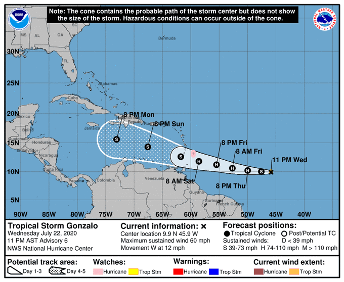
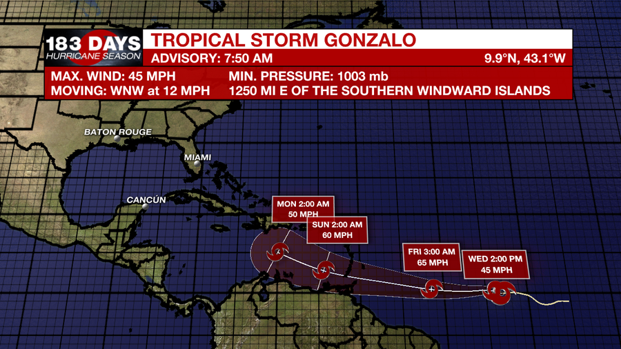
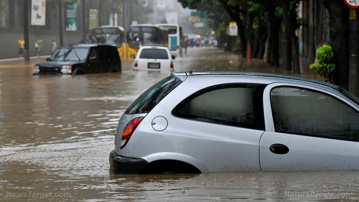
The Hurricane season is causing devastation from the Pacific to the Atlantic as seven active storms are currently swirling across the globe – with high chances an eighth powerful storm will soon develop to break an all-time record.

And actually there is an additional storm that is also developing in the Pacific which could bring the grand total to nine.

Overall, there have been 9 named storms in the Atlantic and 15 names storms in the Pacific since the official start of the hurricane season.

That is not normal.

In fact, one veteran meteorologist has said that he has “NEVER seen so much activity in the tropics”…

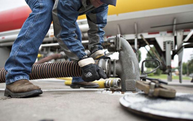
Far from being the biggest threat facing the US coastline this hurricane season, Florence will be followed by several other storms that rapidly strengthening in the Atlantic.

…click on the above link to read the rest of the article…

“A Life Changing Event”: 3 Million To Lose Power, Hog Farmers Panic As Hurricane Set To Smash Into Coast

With Hurricane Florence barreling down on North Carolina, local industries – especially hog farmers – are preparing for the worst. Meanwhile, millions are at risk of losing power as they brace for a historic weather event.

According to David Fountain, Duke Energy’s president for North Carolina, up to 3 million homes  and businesses are at risk of losing power as a result of the hurricane, which in a worst case scenario would come onshore at Wilmington, North Carolina and move through Raleigh, Greensboro and Charlotte.

Natural devastation aside, there is the crippling impact the storm will have on local businesses: one of the biggest industries in the storm’s path is hog farming. Hundreds of farms are in the direct path of the hurricane and are scrambling to prepare for its impact by stockpiling feed and moving their livestock, according to this Wall Street Journal article. Preparations to manage millions of gallons of hog waste are also underway.

The worst case scenario for North Carolina, with its 2,100 hog farms and 9 million pigs and hogs, would be to cripple the local hog farming industry. The potential devastation for hog farmers would be a deja vu to what happened after Hurricane Floyd struck in 1999. The result was the destruction of many farms, including flooding, dead livestock and waste leaking into waterways.

Preparations for the worst have been aided by a dry summer which has, in turn, kept waste lagoon levels low. Power is also of the essence, because farmers are at risk of losing livestock if their barns can’t be ventilated.

Still, some are optimistic: the CEO of the North Carolina Pork Council, Andy Curliss, believes that farmers will be prepared this time around: “They’ll deal with what’s thrown at them,” he told the Wall Street Journal.

…click on the above link to read the rest of the article…

“Worst Storm In US History” Florence Set To Break All-Time Records; Forecasters Fear Harvey Flood Redux

The latest computer forecasts from Tuesday afternoon have predicted that Hurricane Florence, still a Category 4 yet growing larger and more powerful, may shift and hit somewhere near the border between North and South Carolina as coastal residents flee what may be the most powerful hurricane to hit the state in 64 years, according to Bloomberg.

“Florence is expected to stall and wander near or over the coast for as many as four days, dumping prodigious amounts of rain,” said meteorologist Jeff Masters of Weather Underground, who added “If a significant portion of the storm’s circulation remains over water, as occurred last year with Hurricane Harvey’s stall over Southeast Texas — or even if Florence were to move into the higher terrain of western North Carolina and then stall — the rain may break all-time state records for rainfall from a hurricane or tropical storm.


Southeast braces for Hurricane : https://abcn.ws/2N39hJ4


…click on the above link to read the rest of the article…

‘Prepare For The Worst’: Florence Strengthens To A Category 4 Hurricane

‘Prepare For The Worst’: Florence Strengthens To A Category 4 Hurricane

As Hurricane Florence continues on its path toward the east coast, South Carolina Governor Henry McMaster had some good advice. “Plan for the worst, pray for the best,” said the governor.

Hurricane Florence has increased in strength quickly to a category 4 storm, with a potentially catastrophic outcome. “Now is the time for your family also to prepare and stay tuned for more updates,”  McMaster also said. According to USA Today, a coastal North Carolina county on Monday issued a mandatory evacuation order for its entire population as Hurricane Florence strengthened to a Category 4 storm and continued its slow but violent trek toward the East Coast of the United States.

The National Hurricane Center said Florence is expected to slam into the coast around North and South Carolina as a Category 3 or 4 hurricane on Thursday or Friday. The storm’s winds had increased to 130 mph on Monday.  The governor of North Carolina, Roy Cooper has already asked president Donald Trump to declare Florence a federal disaster ahead of the storm. Of course, that won’t help those in its destructive path.

The hurricane center’s description of a Category 4 hurricane begins with “catastrophic damage will occur.” The center warns that such storms will snap or uproot most trees and down power poles and that power can be out in some areas for weeks or months.  Any Category 3, or higher hurricane is classified as a major hurricane.

The hurricane center warned that the swells are likely to cause “life-threatening” surf and current conditions. Even before the evacuation order, Dare County emergency officials warned that rough seas and strong rip currents are already creating dangerous conditions. Florence is going to pose a very serious threat to those living on the East Coast later this week, according to AccuWeather. Florence could also increase in intensity and become a category 5 hurricane before it slams into the east coast later this week, warned AccuWeather. 

…click on the above link to read the rest of the article…

US East Coast On Alert As Tropical Storm Florence Poised To Strengthen

The 5 am National Hurricane Center (NHC) Report has indicated that the risk for a direct impact from Tropical Storm Florence has increased, although exactly where on the East Coast remains uncertain. Residents of the East Coast should be on heightened alert for the potentially dangerous storm, which is expected to become a major hurricane again in the next 12 to 24 hours as it approaches the US.

Still almost 1,500 miles from North Carolina’s Outer Banks, the tropical storm remains 5 to 7 days from a direct US landfall, according to the NHC. As of Saturday morning, Florence had winds of 65 mph and was moving to the west at 9 mph. The center of the storm was about 840 miles southeast of Bermuda.

The latest NHC forecast shows Florence approaching the US East Coast as a powerful Category 4 hurricane with 145 mph winds early next week.

Heavy rain could cause catastrophic flooding well inland from where the storm makes landfall, which is possible anywhere from Florida to New England, AccuWeather said.

The path of Florence is likely to remain steady for the next several days, but a deviation in the storm’s trajectory could develop as it approaches the Eastern Seaboard.

“An area of high pressure over the central Atlantic will bridge westward and join with an existing high pressure near the U.S. East coast over the next several days,” said AccuWeather Hurricane Expert Dan Kottlowski.

“This setup will guide Florence on a west to northwesterly course into next week,” Kottlowski said.

If the high-pressure area weakens next week, then Florence could curve northward then northeastward out to sea with impacts in the US limited.

…click on the above link to read the rest of the article…

Hawaii Braces For Powerful Cat 4 Hurricane, Could See Direct Hit

A hurricane warning has been declared for Hawaii and Maui Counties as powerful Hurricane Lane continues moving west-northwestward towards the main Hawaiian islands as a Category 4 storm.

The Central Pacific Hurricane Center issued the warning early Wednesday (500 AM HST Wed. Aug 22), which means hurricane conditions are expected within 36 hours. A hurricane watch is still in effect for Honolulu and Kauai counties with deteriorating conditions expected within 48 hours.

Early Wednesday, Lane weakened somewhat from Category 5, becoming a Category 4 storm and has maximum sustained winds near 155 mph. Forecasters say there is the possibility of the hurricane making a direct hit on one or more of the islands late this week and into this weekend.

“Lane was centered 315 miles south of Kailua-Kona, and moving west-northwest at 9 mph. Forecasters say hurricane-force winds will extend 40 miles from the center, while tropical-storm-force winds can be felt 140 miles from the eye,” said Hawaii Public Radio.

Local officials are hoping the storm tracks farther west because it would lessen the severity of impacts. The strength of the storm will depend on the storm’s track in the next 12 to 24 hours.

Hawaii Gov. David Ige signed an emergency proclamation in advance of the hurricane. Schools have been shut down as the islands prepare the possibility of a direct hit.


View image on TwitterView image on Twitter

RT @Hawaii_EMA State EOC is now activated and ready to support the counties. State and federal emergency managers on-deck.


According to the latest forecast model from NOAALane will remain very strong, and dangerous.

“Lane started to turn to the west-northwest on last night. Forecasters expect it to turn northwest and then to the north-northwest tomorrow, bringing it “dangerously close” to the island chain. Weather officials say Lane can bring 10 – 15 inches of rain in some spots, but may be higher in other areas. Rain of this magnitude raises the risk of flash flooding and landslides,” said Hawaii Public Radio.

…click on the above link to read the rest of the article…

Olduvai IV: Courage
Click on image to read excerpts

Olduvai II: Exodus
Click on image to purchase

Click on image to purchase @ FriesenPress