Home » Posts tagged 'florida'

Tag Archives: florida

Olduvai
Click on image to purchase

Olduvai III: Catacylsm
Click on image to purchase

Post categories

Post Archives by Category

Orange Juice Prices Soar To Record Highs As Inventories Collapse

Orange Juice Prices Soar To Record Highs As Inventories Collapse

We recently outlined Orange Juice Prices Could “Increase Substantially” As Hurricane Pummels Florida’s Top Citrus Grow Region.” And that’s precisely what’s happening today.

First, let’s begin with US stockpiles of cold-stored orange juice plunged by 43% in September from a year earlier — the lowest level since 1977, according to the latest US Department of Agriculture data.

A combination of crop diseases across Florida’s citrus groves and Hurricane Ian that destroyed crops are creating a supply crunch that has catapulted orange juice futures contracts to as high as $2.18 per pound, the highest level ever.

Ahead of Hurricane Ian, we penned a note titled OJ Squeeze Ahead? Tropical Threat Looms For Florida’s Citrus Groves” and warned this may spark even higher breakfast inflation. Last month, we noted that a dozen eggs at the supermarket have jumped to record highs due to devastating bird flu.

Sticky food inflation continues to wreak havoc on households, as shown in the latest CPI report.

Breakfast was cheap but has since become expensive as orange juice and egg prices soar to record highs.

The latest on Ian’s impact on the supply chain

The latest on Ian’s impact on the supply chain

Ports, airports remain closed in wake of hurricane

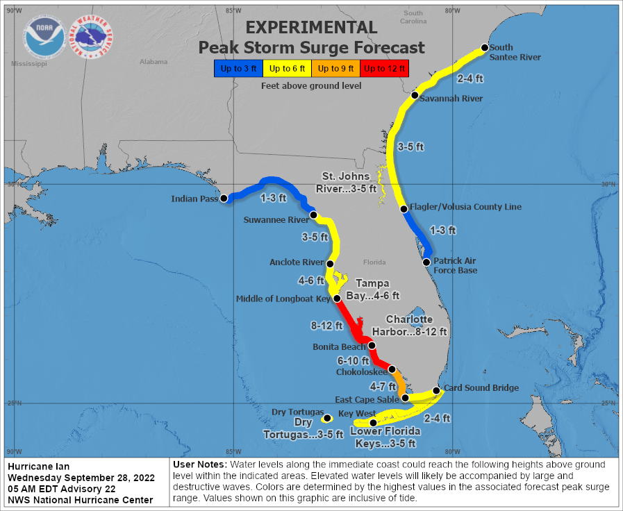
Floridians are starting to assess the damage created by Hurricane Ian a day after it slammed into the Gulf Coast as a massive Category 4 storm. By Thursday morning, Ian had been downgraded to a tropical storm, but a threat remains as it continues to bring heavy winds and rain to the state.

As of 11:54 a.m. EDT, more than 2.6 million Floridians were without power, with some counties, including Hardee, almost completely in the dark.

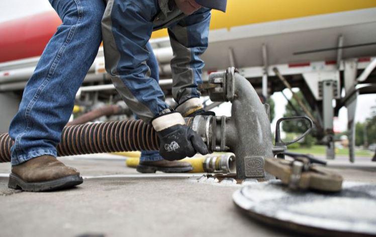
Nearly 20% of Tampa gas stations have reported fuel shortage and access issues.

As previously reported, the logistics impacts could last for weeks — or longer.

Here’s the latest as of 11:30 a.m. EDT:

Roads and bridges

In a news conference Thursday morning in Tallahassee, Gov. Ron DeSantis said the Florida Department of Transportation (FDOT) is working to make sure roads and interstate highways are open.

Most of Interstate 75 remains open, according to FDOT, with some interruptions.

“Alligator Alley on I-75 across into Collier and Lee County is open and flowing,” DeSantis said. “I-75 south through Charlotte County is open and flowing. Portions of Lee County they are still looking at.”

Additionally, part of the Sanibel Causeway Bridge, a major bridge that connects Fort Myers to Sanibel Island, has been washed out.

Hurricane Ian Strengthens To Powerful Category 4 As Florida Landfall Imminent

Hurricane Ian Strengthens To Powerful Category 4 As Florida Landfall Imminent

Hurricane Ian strengthened into a powerful Category 4 storm expected to make landfall on Florida’s southwest coast today and then traverse central Florida and emerge in the Atlantic by Thursday.

At 0500 ET, the National Hurricane Center said Ian sustained maximum winds of 140 mph and gusts up to 165 mph. The storm’s center was about 75 miles west-southwest of Naples and 105 miles south-southwest of Punta Gorda, moving north-northeast at 10 mph.

“Ian is forecast to approach the west coast of Florida as an extremely dangerous major hurricane, weakening is expected after landfall.

“On the forecast track, the center of Ian is expected to approach the west coast of Florida within the hurricane warning area this morning, and move onshore later today. The center of Ian is forecast to move over central Florida tonight and Thursday morning and emerge over the western Atlantic by late Thursday,” NHC senior hurricane specialist Daniel Brown told Orlando Sentinel

Ian’s path has shifted south of Tampa Bay, and landfall is now expected between Fort Myers and Sarasota on Wednesday morning or early afternoon before moving across the central part of the state.

NHC warned a “life-threatening storm surge is expected along the Florida west coast and the Lower Florida Keys,” with “devastating wind damage” expected near Ian’s center.

“Catastrophic flooding is expected across portions of central Florida with considerable flooding in southern Florida, northern Florida, southeastern Georgia and coastal South Carolina,” the weather agency continued.

“It’s going to be historic,” National Weather Service Melbourne meteorologist Kole Fehling in Melbourne, referring to the storm’s landfall impacts.

Fehling said Central Florida could be swamped with 15 to 20 inches of rainfall, with some areas receiving upwards of 24 inches.

…click on the above link to read the rest of the article…

They Will Reap What They Sowed

THEY WILL REAP WHAT THEY SOWED

“Do not be deceived: God cannot be mocked. A man reaps what he sows. The one who sows to please his sinful nature, from that nature will reap destruction; the one who sows to please the Spirit, from the Spirit will reap eternal life. Let us not become weary in doing good, for at the proper time we will reap a harvest if we do not give up.” – Galations 6

US Using 15 Military Bases As Coronavirus Quarantine Locations

Via the CDC

“I have certain rules I live by. My first rule: I don’t believe anything the government tells me. Sooner or later the people in this country are going to realize: the government does not give a fuck about them. The government doesn’t care about you, or your children, or your rights, or your welfare, or your safety. It simply doesn’t give a fuck about you. It’s interested in its own power. That’s the only thing keeping it and expanding it wherever possible.” – George Carlin

In a previous article – Cascade of Consequences – I attempted to make the case the ruthless billionaire oligarchs and their bought off lackey whores in government, media, academia, corporations, the military industrial complex, sickcare industry, and  Federal Reserve have used this engineered covid pandemia to further consolidate and expand their wealth, power and control over a frightened, willfully ignorant, compliant populace. In the month since that article the “powers that be” have ramped up the fear, increased their coercive mandates, reinstated mask mandates, and instituted vaccine passports in liberal bastion cities across America.

I see these ham-handed authoritarian dictates as a sign of weakness and their false narrative falling apart. A sense of desperation wafts from the halls of power in DC, corporate executive suites, and left-wing media outlets on the coasts who have overplayed their tyrannical hand. Resistance is building among an irate minority of critical thinking individuals who follow George Carlin’s first rule.

…click on the above link to read the rest of the article…

Floridians Brace For Dorian As Hurricane Weakens To Category 3

Floridians Brace For Dorian As Hurricane Weakens To Category 3

Hurricane Dorian has weakened from a Category 4 storm down to Category 3, now with winds of 120 miles per hour, but experts and officials say it’s too soon for Floridians to relax.

The storm stalled over the island of Grand Bahama for a day, staying in roughly the same position for 12 hours. Prime Minister Hubert Minnis described the storm as a “historic tragedy,” with five people confirmed to have died. Roughly 13,000 homes have been destroyed or seriously damaged.

Now, it’s setting its sights on the Eastern seaboard. There are already reports of flooding in Miami.

 …click on the above link to read the rest of the article…

“Things Are Going To Get Worse” – Florida Gas Shortages Intensify As Dorian Becomes Category 3 Hurricane

“Things Are Going To Get Worse” – Florida Gas Shortages Intensify As Dorian Becomes Category 3 Hurricane

Hurricane Dorian strengthened to a Cat 3 storm Friday afternoon with 115 mph winds as Florida Gov. Ron DeSantis promised state troopers would escort trucks of fuel to areas along the east coast that could be directly in the storm’s path amid worsening fuel shortages, ABC Newsreported.

Following several seriously damaging hurricane seasons in recent years, stores and gas stations were already reporting outages of critical supplies like bottled water and gas on Thursdayand the situation only got worse on Friday, as even more gas stations reported running out of fuel.

Gasoline price-tracking app GasBuddy estimated that 31% of retail gas sellers in the Orlando-Daytona Beach-Melbourne area were dry as of Friday morning, according to Bloomberg.


.@FLHSMV FHP State Troopers will provide escorts to fuel trucks to ensure they reach critical areas more quickly. We are working closely with the fuel industry to ensure there is an adequate supply of fuel statewide as Hurricane #Dorian approaches.


Despite being the third-most-populous state in the country, Florida doesn’t have a single fuel pipeline. The nearest one is a Colonial line that delivers to Bainbridge, Georgia. From there, gas is loaded onto trucks and shipped to gas stations. The state also relies on tanker deliveries for fuel, which could create serious problems if the storm leaves the state’s ports shut for days, BBG reports.

Florida Petroleum Marketers Association executive director Ned Bowman said trucks were lined up at wholesale fuel terminals. Two tankers carrying refined petroleum products were heading to a port in the Everglades near Fort Lauderdale. Despite this, Bowman said the supply situation was still “pretty good.” 

 …click on the above link to read the rest of the article…

“I Feel Helpless”: Bottled Water, Gas Shortages Reported As Floridians Brace For Hurricane Dorian

“I Feel Helpless”: Bottled Water, Gas Shortages Reported As Floridians Brace For Hurricane Dorian 

By now, this has become a familiar scene for millions of Americans, particularly those living in the southeastern states of Florida, Georgia and the Carolinas, as well as Texas and Louisiana, all of which have been rocked by major hurricanes in recent years. With Hurricane Dorian barreling toward Florida, expected to make landfall as a powerful Category 4 hurricane, with 130 mph winds, this weekend.

According to WSJ, Floridians could begin feeling the impact of the storm as soon as Saturday. The NHC said Thursday that the storm is a Category 1 hurricane with sustained winds of 85 mph, moving northwest over the Atlantic Ocean. Though it’s too early to say exactly where it will make landfall, projections suggest it will hit the northwestern Bahamas before moving on to central and southern Florida. 

In Orange County, residents have already begun filling up sandbags at a local park.

The Bahamas and Florida could be under a hurricane watch as soon as Thursday evening. But Fla. Gov. Ron DeSantis has already declared a state of emergency that has been expanded to 67 counties, and secured promises of assistance from President Trump.

“The message I think right now is that all Floridians really need to monitor Hurricane Dorian and make necessary preparations,” said Florida Gov. Ron DeSantis at a news conference Thursday morning. “This is a track that has a significant amount of uncertainty.”

The entire East Coast of Florida is within the potential travel path of the storm, yet no evacuation orders have been issued yet. But the rush to stock up had already brought on fuel shortages in the Cape Canaveral area.

Those who have decided to remain in the area over the weekend are stocking up on essentials: Gasoline, packaged food, bottled water, batteries and other essentials.

 …click on the above link to read the rest of the article…

Florida Declares State Of Emergency As Hurricane Dorian Set To Ruin Labor Day Weekend

Florida Declares State Of Emergency As Hurricane Dorian Set To Ruin Labor Day Weekend

Just in time to spoil Labor Day weekend, Hurricane Dorian has barreled through the US Virgin Islands and Puerto Rico without causing much damage, and is now headed straight for the Florida coastline. After intensifying from a tropical storm into a hurricane late Wednesday, the storm continued to strengthen as it pulled closer to the Continental US.

The storm is expected to continue strengthening over the next few day, and is expected to make landfall on Florida’s Atlantic coast as a CAT 3 storm late Sunday or Monday.


Hurricane Dorian is strengthening and may hit the US as a Category 3. It’s forecast to grow into a major storm over Labor Day weekend before making landfall along the east coast of Florida. https://cnn.it/32f6wYq 

Track Dorian: https://cnn.it/2zqdugK 


In typical fashion, president Trump warned that Dorian will be “a very big storm, perhaps one of the biggest!” and urged people to follow state and federal instructions.


Hurricane Dorian looks like it will be hitting Florida late Sunday night. Be prepared and please follow State and Federal instructions, it will be a very big Hurricane, perhaps one of the biggest!


As of 5 am ET on Thursday, Dorian’s center was some 150 miles north-northwest of San Juan, as it headed northwest at 13 mph, according to the National Hurricane Center. Dorian’s sustained winds increased to 85 mph, with higher gusts recorded.

Heavy rain from the storm could cause “life threatening” flash floods in parts of the Bahamas on Thursday, and even along the southeastern US coast.

CBS News weather producer David Parkinson said that “with a new supermoon and the angle the storm is approaching from, widespread coastal flooding, including severe coastal flooding is likely. In addition, as the storm is coming in for landfall, it looks like it might lose some of the steering currents.”

 …click on the above link to read the rest of the article…

Hurricane Michael’s Impact On Gasoline Demand

Hurricane Michael’s Impact On Gasoline Demand

Fuel pump

Gasoline demand increased in the Florida Panhandle, southern Georgia, and South Carolina ahead of Hurricane Michael’s arrival to the areas, but repercussions to demand appeared to focus on rack cities in the direct path of the storm, according to our Supply Side daily rack volume data. The increased rack activity provided some uplift to PADD 1C demand Oct. 7 to 10. Daily rack activity on Oct. 9 jumped to the highest daily level since the approach of Hurricane Florence to the Carolinas in September.

Michael’s long-term ramifications to supply are not yet obvious. Ports along the upper Gulf Coast and southern Atlantic Coast closed either completely or to inbound traffic starting Oct. 9. Restrictions on ports in Mississippi, Alabama, Florida, North Carolina, and Virginia remained as of Oct. 12, with Savannah and Charleston reopening Oct. 11. Gasoline supply in these five states relies upon waterborne barge movements from the U.S. Gulf Coast (PADD 3) and cargo imports. To add to the constrained inflows, Colonial Pipeline reported power outages at delivery facilities in southern Georgia on Oct. 11. Colonial assessed damages and impacts to Line 17, which runs from Atlanta to Bainbridge, GA, off Colonial’s 2.6mn bpd mainline system.

Hurricane Michael made landfall as a Category 4 hurricane on Oct. 10 near Mexico Beach, FL, with maximum sustained winds of 155 mph—the strongest tropical cyclone to hit the Florida Panhandle in recorded history and the fourth strongest Atlantic tropical cyclone to hit the U.S. mainland. When Michael moved into Georgia on the evening of Oct. 10, the storm became the most intense disturbance to hit the state since 1898. The cyclone made its way through Florida, Georgia, South Carolina, North Carolina and Virginia. As of Oct. 12, Michael was a post-tropical cyclone off the coast of Delaware, heading northeast towards open water.

…click on the above link to read the rest of the article…

“An Atomic Bomb Has Hit Our City”: ‘Apocalyptic’ Post-Michael Scenes From Mexico Beach

If the nine-foot storm surge didn’t get them, the 150+ mph winds did.

As Michael, the third-most-powerful hurricane to ever make landfall in the Continental US, prepares to make its exit into the Atlantic Ocean on Friday, many residents of the Florida panhandle are still in shock as those who fled try to return, and those who stayed recount watching in abject horror as their community was leveled by flood waters and wind during one of the most aggressive storms in US history. In interviews with reporters who managed the difficult journey to Mexico Beach to survey the damage, many residents struggled to choke back tears as they described how they watched in abject horror as the water and wind ripped homes from their foundations. Out of the chaos, many quickly realized that Florida Gov. Rick Scott’s prophesy of “unimaginable devastation” had come to pass.

Mike

John Humphress, a storm chaser and drone pilot who spoke with the Associated Press about the damage, described the scene in Mexico Beach, Fla., what will be remembered as Hurricane Michael’s “ground zero”, in one word: “Apocalyptic.”

According to state officials, some 285 people in Mexico Beach refused to obey the mandatory evacuation order and thus obtained a front-row seat to the destruction from what some meteorologists have described as “the perfect storm.” While National Guard rescuers pushed into the storm zone on Thursday and rescued 20 survivors, the fate of dozens more remains unknown. FEMA Administration Brock Long put it best when he said the entire town of 1,100 had been “wiped out.”

First responders were forced to wait until after daylight on Thursday morning to access Mexico Beach as flooding from the storm had left it entirely cut off.

Two

…click on the above link to read the rest of the article…

“I Have No Words”: Aerial Footage Shows Trail Of Devastation Left By Hurricane Michael

Florida search-and-rescue teams are searching for survivors after Hurricane Michael carved a path of devastation through several communities. According to FEMA administrator Brock Long, Mexico Beach “took the brunt’ of Michael’s carnage, adding “That’s probably ground zero.”

“Today is a big day for us when it comes to helping people,” said Long during the Thursday morning press briefing, adding “Power is not going to be on for a while.

The latest developments, per the New York Times

At least four deaths were linked to the storm in Gadsden County, west of Tallahassee, according to Lt. Anglie Hightower, a spokeswoman for the sheriff’s office. The victims included a man who died when a tree crashed down on his home in Greensboro.

An 11-year-old girl, Sarah Radney, was killed on Wednesday when a carport was torn away and was sent hurtling into the modular home she was in, said Chad Smith, the coroner of Seminole County, Ga. “She was sitting right next to her grandmother,” said Mr. Smith, who described the girl’s death as a “horrible accident.”

• Emergency officials rushed to evacuate more than 300 patients from storm-damaged hospitals in Panama City. In total, four hospitals and 11 nursing facilities were closed in Florida. A nursing facility in Georgia was also closed.

Much of the coast of the Florida Panhandle, including parts of Panama City and Mexico Beach, was left in ruins. The area is dotted with small, rural communities, some of them among the poorest in the state. Evacuation was difficult.Read more about how the storm was hard on people without the means to evacuate.

…click on the above link to read the rest of the article…

2 Dead, 700,000 Without Power As Damages From “Nightmare” Michael Top $20 Billion

As it moved inland over Georgia on track to hammer some parts of South and North Carolina that haven’t yet recovered from Hurricane Florence, Hurricane Michael was downgraded to a tropical storm Wednesday night. It’s expected to exit the Continent on Friday, leaving a more than 200-mile long trail of devastation and what’s expected to be roughly $20 billion in damages as it tears through the southeastern US. Already, 2 deaths have been confirmed, and it’s believed that more will come. During the latest update, the storm was 30 miles west of Augusta, Georgia and is headed into South Carolina. 

Michael

(Courtesy of Accuweather)

Despite the downgrades, Michael has cemented its status as the third most powerful storm to ever make landfall in the Continental US. Strong winds and torrential rains continued to batter Georgia overnight and have spread to South Carolina as well. According to Accuweather, winds reached 60 mph across Georgia overnight, and speeds were expected across the Carolinas over the next 24 hours.

More than 700,000 homes and businesses had lost power in Florida, Alabama and Georgia early on Thursday. The governors of North and South Carolina warned about coming heavy rain and storm-force winds as Michael moved north along the Atlantic seaboard. The NHC warned that the storm could cause life-threatening flash flooding on Thursday and Friday across the Carolinas, Georgia and as far away as Virginia.

To provide an update on the status of disaster relief, the head of the NHC will give a news conference at 8:30 am ET:

Mike

As residents prepare themselves for the monumental task of rebuilding after the storm reduced thousands of homes to splinters, scientists and first responders are reflecting on how Michael intensified from a tropical storm with negligible expected impact on Saturday to a borderline Category 5 storm that was among the most powerful to ever come ashore in the US – and certainly the most powerful storm to ever hit the Florida panhandle since record-keeping began.

…click on the above link to read the rest of the article…

“A Once In A Lifetime Event”: Michael Will Be The Strongest Hurricane To Hit US In 14 Years

Update (9 am ET): Hurricane Michael continued to strengthen Wednesday morning, as the Category 4 storm’s wind speed increased to 145 mph. The storm is now poised to be the strongest to hit the US in 14 years, boasting a life threatening storm surge and the potential to cause $16 billion in damages.

The storm is now roughly 90 miles southwest of Panama City and is heading north at 13 miles per hour, according to the NHC’s latest update. The storm’s outer bands are already battering the coastal town of Apalachicola with winds of nearly 50 mph.


Here is the 8 AM CDT position update for – water levels are rising and winds increasing along the Florida Panhandle as potentially catastrophic approaches.


As it stands, the storm is also poised to be the strongest to hit the Florida panhandle and big bend since meteorologists first started gathering data. Regional ports have closed in anticipation, and more than 230 flights have been canceled. Duke Energy Corp., a utility that supplies electricity to the region, expects more than 200,000 customers in the state will be without power. In preparation for the widespread outages, local utilities have about 19,000 workers on stand by ready to work to quickly restore power, with more workers pouring in from out of state. Still, some areas are expected to be without power for more than a week, per the Daily Commercial.

“A storm like this could be a once-in-a-lifetime event,” said Brett Rathbun, a meteorologist with AccuWeather Inc. in State College, Pennsylvania. “Winds of this intensity can really knock down any tree or structure in its path.”

…click on the above link to read the rest of the article…

Evacuations Ordered As “Monstrous Hurricane” Michael Intensifies Into “Most Powerful Storm In A Decade

In a repeat of the scramble for safety that preceded the landfall of Hurricane Irma during the 2017 storm season, residents of the Florida panhandle are boarding up homes and fleeing inland as Hurricane Michael, already a Category 1 storm following a rapid intensification over the past 24 hours, barrels toward the northern Gulf of Mexico, where it’s projected to make landfall on Wednesday, possibly as a Category 3 storm.


Hurricane Michael is moving north-northwestward over the Gulf of Mexico. Here are the 4 am CDT October 9th Key Messages on Hurricane .

“The center of Michael is expected to move inland over the Florida Panhandle or Florida Big Bend area on Wednesday, and then move northeastward across the southeastern U.S. Wednesday night and Thursday,” the U.S. National Hurricane Center said in an advisory at 5 a.m. New York time.

Michael

The hurricane could generate a 12-foot surge, and 4-8 inches of rain in the region, with isolated areas getting as much as 12 inches. Michael is arriving less than a month after Florence hit North Carolina on Sept. 14, causing devastating floods, killing at least 39 and causing about $45 billion in estimated damages. Duke Energy Corp. warned customers in the region to prepare for potential outages.

After initially forming over the coast of Honduras, Michael battered western Cuba and Mexico’s Yucatan Peninsula over the weekend, causing flash flooding that left 13 dead, per CNN. With a hurricane warning in place from the Alabama-Florida border to the Suwannee River in Florida, and a hurricane watch in effect for the coast of Alabama, Florida’s governor Rick Scott called Michael “a monstrous hurricane“, and declared a state of emergency for 35 Florida counties from the panhandle to Tampa Bay.

Michael

…click on the above link to read the rest of the article…

Michael Is Now A Hurricane, Will Continue To Strengthen As It Approaches Florida Panhandle

Update from Reuters:

  • MICHAEL BECOMES A HURRICANE AND CONTINUED STRENGTHENING EXPECTED, HEAVY RAINFALL AND STRONG WINDS SPREADING ACROSS WESTERN CUBA, RISK OF LIFE-THREATENING STORM SURGE, HEAVY RAINFALL, AND DANGEROUS WINDS INCREASING FOR THE NORTHEASTERN GULF COAST: NHC

* * *

A new tropical storm has developed off Mexico’s Yucatan Peninsula and could become a dangerous Category 2 hurricane with an expected Wednesday landfall on the Gulf Coast in the Florida Panhandle region.

Hurricane watches have been issued for northwest and north central Florida ahead of Tropical Storm Michael. Forecasters say Michael could strengthen into a major hurricane as it approaches Florida’s coastline by midweek with dangerous storm surge flooding, hurricane winds, and heavy rainfall. Per the latest Weather Channel update, Michael is located 90 miles east of Cozumel, Mexico, and is moving northward at 7mph.

Hurricane watches have been issued for the Northwest Gulf Coast from Alabama/Florida border to Suwanee River, Florida. The Weather Channel said this includes Pensacola, Panama City, and Tallahassee.

Tropical storm watches have also been issued from Suwanee River, Florida, to Anna Maria Island, Florida, including Tampa Bay and  from the Alabama/Florida border to the Mississippi/Alabama border.

“Michael will continue to move northward into the central Gulf of Mexico early this week, strengthening as it does so. As it approaches the eastern Gulf Coast, it will encounter a favorable environment for strengthening, and may become a Category 1-2 hurricane prior to landfall in the Florida Panhandle. There is an outside this system strengthens even more than forecast, but confidence on this scenario is low. Regardless, Michael should remain east of significant oil refineries as it approaches landfall early Wednesday, but unsettled weather as far as Louisiana is possible. Winds sustained between 80-100mph are possible along with significant rainfall and flooding along its track through this week,” said Ed Vallee, head meteorologist at Vallee Weather Consulting LLC.

…click on the above link to read the rest of the article…

Olduvai IV: Courage
Click on image to read excerpts

Olduvai II: Exodus
Click on image to purchase

Click on image to purchase @ FriesenPress